Lake Athabasca
| Lake Athabasca | |
|---|---|
 Ice breakup on Lake Athabasca (June 9, 2002)[1] | |
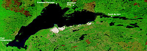 Lake Athabasca (August 24, 2002)[2] | |
| Location | Division No. 18, Saskatchewan / Wood Buffalo, Alberta |
| Coordinates | 59°16′N 109°27′W / 59.267°N 109.450°W / 59.267; -109.450Coordinates: 59°16′N 109°27′W / 59.267°N 109.450°W / 59.267; -109.450 |
| Primary inflows | Peace River, which backs up through Rivière des Rochers during flooding, Athabasca River, William River, MacFarlane River, Colin River, Fond du Lac River, |
| Primary outflows | Rivière des Rochers that meets with the Peace to form the Slave |
| Catchment area | 274,540 km2 (106,000 sq mi) |
Basin countries | Canada |
| Max. length | 283 km (176 mi) |
| Max. width | 50 km (31 mi) |
| Surface area | 7,850 km2 (3,030 sq mi)[3] |
| Max. depth | 124 m (407 ft) |
| Shore length1 | ~1,900 km (1,200 mi) |
| Surface elevation | 213 m (699 ft) |
| Settlements | Fort Chipewyan, Uranium City, Camsell Portage, Fond du Lac |
| References | [3] |
1 Shore length is not a well-defined measure. | |
Lake Athabasca (/ˌæθəˈbæskə/; French: lac Athabasca; from Woods Cree: aðapaskāw, "[where] there are plants one after another")[4] is located in the northwest corner of Saskatchewan and the northeast corner of Alberta between 58° and 60° N. The lake is 26% in Alberta and 74% in Saskatchewan.
Contents
1 History
2 Geography and natural history
2.1 Tributaries
3 Development and environment
4 See also
5 References
6 External links
History
The name in the Dene language originally referred only to the large delta formed by the confluence of the Athabasca River at the southwest corner of the lake. Prior to 1789, Sir Alexander Mackenzie explored the lake. In 1791, Philip Turnor, cartographer for the Hudson’s Bay Company, wrote in his journal, "low swampy ground on the South side with a few willows growing upon it, from which the Lake in general takes its name Athapison in the Southern Cree tongue which signifies open country such as lakes with willows and grass growing about them". Peter Fidler originally recorded the name for the river in 1790 as the Great Arabuska. By 1801, the name had gained a closer spelling to the current name—Athapaskow Lake. By 1820, George Simpson referred to both the lake and the river as "Athabasca".
Geography and natural history

Lake Athabasca, Canada
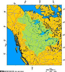
Mackenzie River drainage basin showing Lake Athabasca's position south of Great Slave Lake
The lake covers 7,850 km2 (3,030 sq mi), is 283 km (176 mi) long, has a maximum width of 50 km (31 mi), and a maximum depth of 124 m (407 ft), and holds 204 km3 (49 cu mi) of water, making it the largest and deepest lake in both Alberta and Saskatchewan, and the eighth largest in Canada.[5] Water flows northward from the lake via the Slave River and Mackenzie River systems, eventually reaching the Arctic Ocean.
Fort Chipewyan, one of the oldest European settlements in Alberta, is located on the western shore of the lake, where the Rivière des Rochers drains the lake and flows toward Slave River, beginning its northward journey along the eastern boundary of Wood Buffalo National Park. The eastern section of the lake narrows to a width of about 1 km (.6 miles) near the community of Fond du Lac located on the northern shore then continues to its most easterly point at the mouth of the Fond du Lac River.
Fidler Point on the north shore of Lake Athabasca is named for Peter Fidler, a surveyor and map maker for the Hudson's Bay Company.[6]
Along with other lakes such as the Great Bear Lake and Great Slave Lake, Lake Athabasca is a remnant of the vast Glacial Lake McConnell.
Tributaries
Tributaries of Lake Athabasca include (going clockwise); Fond du Lac River, Otherside River, Helmer Creek, MacFarlane River, Archibald River, William River, Ennuyeuse Creek, Dumville Creek, Debussac Creek, Jackfish Creek, Claussen Creek, Old Fort River, Crown Creek, Athabasca River, Colin River, Oldman River, Bulyea River, Grease River and Robillard River.[7][8]
Development and environment
Uranium and gold mining along the northern shore resulted in the birth of Uranium City, Saskatchewan, which was home to the mine workers and their families. While the last mine closed in the 1980s, the effects of mining operations have heavily contaminated the northern shores. The large oil sands mining nearby is suspected to have added to the current pollution levels in the lake.[9]
On October 31, 2013, one of Obed Mountain coal mine's pits failed, and from between 600 million to a billion liters of slurry poured into the Plante and Apetowun Creeks.[10] The plume of waste products then joined the Athabasca River, travelling downstream for a month before settling in Lake Athabasca near Fort Chipewyan, over 500 km (310 mi) away.[10]
The Lake Athabasca Sand Dunes, the largest active sand dunes in the world north of 58°, are adjacent to the southern shore. The dunes were designated a "Provincial Wilderness Park" in 1992.
Lake Athabasca contains 23 species of fish, with a world record lake trout of 46.3 kg (102 lb) having been caught from its depths in 1961 by means of a gillnet.[11]
Other fish species include walleye, yellow perch, northern pike, goldeye, lake whitefish, cisco, Arctic grayling, burbot, white sucker and longnose sucker.[12]
See also
- Peace–Athabasca Delta
References
^ "Great Slave Lake and Lake Athabasca, Canada (Note: Lake Athabasca during ice-break-up)". June 9, 2002. Retrieved 2013-01-25..mw-parser-output cite.citation{font-style:inherit}.mw-parser-output .citation q{quotes:"""""""'""'"}.mw-parser-output .citation .cs1-lock-free a{background:url("//upload.wikimedia.org/wikipedia/commons/thumb/6/65/Lock-green.svg/9px-Lock-green.svg.png")no-repeat;background-position:right .1em center}.mw-parser-output .citation .cs1-lock-limited a,.mw-parser-output .citation .cs1-lock-registration a{background:url("//upload.wikimedia.org/wikipedia/commons/thumb/d/d6/Lock-gray-alt-2.svg/9px-Lock-gray-alt-2.svg.png")no-repeat;background-position:right .1em center}.mw-parser-output .citation .cs1-lock-subscription a{background:url("//upload.wikimedia.org/wikipedia/commons/thumb/a/aa/Lock-red-alt-2.svg/9px-Lock-red-alt-2.svg.png")no-repeat;background-position:right .1em center}.mw-parser-output .cs1-subscription,.mw-parser-output .cs1-registration{color:#555}.mw-parser-output .cs1-subscription span,.mw-parser-output .cs1-registration span{border-bottom:1px dotted;cursor:help}.mw-parser-output .cs1-ws-icon a{background:url("//upload.wikimedia.org/wikipedia/commons/thumb/4/4c/Wikisource-logo.svg/12px-Wikisource-logo.svg.png")no-repeat;background-position:right .1em center}.mw-parser-output code.cs1-code{color:inherit;background:inherit;border:inherit;padding:inherit}.mw-parser-output .cs1-hidden-error{display:none;font-size:100%}.mw-parser-output .cs1-visible-error{font-size:100%}.mw-parser-output .cs1-maint{display:none;color:#33aa33;margin-left:0.3em}.mw-parser-output .cs1-subscription,.mw-parser-output .cs1-registration,.mw-parser-output .cs1-format{font-size:95%}.mw-parser-output .cs1-kern-left,.mw-parser-output .cs1-kern-wl-left{padding-left:0.2em}.mw-parser-output .cs1-kern-right,.mw-parser-output .cs1-kern-wl-right{padding-right:0.2em}
^ "Burn Scars in Saskatchewan, Canada (Note: Dark to light rust coloured areas are burn scars from forest fires)". August 24, 2002. Retrieved 2015-01-03.
^ ab Atlas of Canada (2004-04-05). "Lakes of Canada". Natural Resources Canada. Archived from the original on 2007-04-10. Retrieved 2007-05-01.
^ Bright, William (2004). Native American Place Names of the United States. Norman: University of Oklahoma Press. p. 52. ISBN 0-8061-3576-X. OCLC 53019644.
^ "Lake Athabasca". Atlas of Alberta Lakes. Edmonton: University of Alberta Press. 1990. ISBN 0-88864-214-8. Archived from the original on 2011-09-28.
^ Place Names - Faria Creek - Friock Creek
^ "Natural Resources Canada-Canadian Geographical Names (Lake Athabasca)". Retrieved 2014-12-28.
^ "Atlas of Canada Toporama". Retrieved 2014-12-28.
^
Elizabeth Southren (2013-01-08). "Deep In Canadian Lakes, Signs Of Tar Sands Pollution". National Public Radio. Archived from the original on 2013-08-01.Canadian researchers have used the mud at the bottom of lakes like a time machine to show that tar sands oil production in Alberta, Canada, is polluting remote regional lakes as far as 50 miles from the operations.
^ ab Wohlberg, Meagan (October 21, 2015). "Two Years Later, Charges Laid in Massive Alberta Coal Mine Spill". Vice News. Retrieved 17 February 2016.
^ "Lake Trout". Perspective Visuals, Inc. March 8, 2006.
^ "Fish Species of Saskatchewan" (PDF). Archived from the original (PDF) on 2011-07-19. Retrieved 2012-10-13.
External links
- Lake Athabasca and associated Sand Dunes
- International Lake Environment Committee, June 21, 2001
- Fish Species of Saskatchewan
- Encyclopedia of Saskatchewan (Lake Athabasca)
- Athabasca Sand Dunes Provincial Park
.mw-parser-output .navbox-canada .navbox-title,.mw-parser-output .navbox-canada th,.mw-parser-output .navbox-canada .navbox-group,.mw-parser-output .navbox-canada .navbox-abovebelow,.mw-parser-output .navbox-canada .navbox-subgroup,.mw-parser-output .navbox-canada .navbox-odd,.mw-parser-output .navbox-canada .navbox-even{background-color:white}.mw-parser-output .navbox-canada .navbox-list .collapsible .navbox-title{box-shadow:inset 1px 1px 0 #C00,inset -1px -1px 0 #C00}.mw-parser-output .navbox-canada-a{box-shadow:inset 1px 1px 0 #C00,inset -1px -1px 0 #C00}.mw-parser-output .navbox-canada-t{box-shadow:inset 0 1px 0 0 #C00}.mw-parser-output .navbox-canada-b{box-shadow:inset 0 -1px 0 0 #C00}.mw-parser-output .navbox-canada-tb{box-shadow:inset 0 1px 0 0 #C00,inset 0 -1px 0 0 #C00} | |
|---|---|
| Provinces |
|
| Territories |
|
| |
Hydrography of Alberta | ||
|---|---|---|
| Rivers |
|  |
| Waterfalls |
| |
| Lakes |
| |
| Reservoirs |
| |
| Glaciers |
| |
| Other |
| |
Authority control |
|
|---|


