Mirpur Model Thana
Mirpur Village মিরপুর | |
|---|---|
Thana | |
 Mirpur Village Location in Bangladesh | |
| Coordinates: 23°48′34″N 90°21′39″E / 23.809309°N 90.360928°E / 23.809309; 90.360928Coordinates: 23°48′34″N 90°21′39″E / 23.809309°N 90.360928°E / 23.809309; 90.360928 | |
| Country | |
| Division | Dhaka Division |
| District | Dhaka District |
| Area | |
| • Total | 58.66 km2 (22.65 sq mi) |
| Population (2007) | |
| • Total | 1,074,232 |
| • Density | 16,838/km2 (43,610/sq mi) |
| Time zone | UTC+6 (BST) |
| Postal Code | 1216 |
| Website | bangladesh.gov.bd/maps/images/dhaka/MirpurT.gif |
Mirpur (Bengali: মীরপুর/মিরপুর) is a thana of Dhaka city, Bangladesh. It is bounded by Pallabi Thana to the north, Mohammadpur Thana to the south, Kafrul to the east, and Savar Upazila to the west.[1]
Contents
1 History
2 Geography
3 Demographics
4 Points of interest
5 Education
6 Sports
7 See also
8 References
History
Mirpur Village was established in 1962. The thana consists of one union porishod, eight wards, 11 mouzas and 86 and 20 villages. Mirpur Thana (Village) area was included in Keraniganj Thana during the British period (1757 to 1947) and in Tejgaon Thana during the Pakistan period (1947 to 1971). After the Liberation War following the victory day, Mirpur was independent on 31 January 1972.
Geography

Panoramic view of Mirpur
Mirpur is located at 23°48′15″N 90°22′00″E / 23.8042°N 90.3667°E / 23.8042; 90.3667. It has a total area of 58.66 km2 (22.65 sq mi) and is situated in the north-east of Dhaka city.
Demographics
At the 2000 census of Bangladesh, Mirpur had a population of 1,074,232, of which males constituted 54.15% and females 45.85%.[2] 610,270 were over the age of 18, and the average literacy rate was 68.9% (7+ years), compared to the national average of 48.6%. Mirpur Thana has recently been divided into the three thanas of Shah Ali, Pallabi and Kafrul.[3]
Points of interest
Mirpur Beribadh (dyke) is a place in Dhaka, the capital of Bangladesh. Mirpur thana is part of the Dhaka District in Dhaka Division. It is famous for various historical places in Dhaka city. The Dhaka Zoo, the National Botanical Garden of Bangladesh, Sher-e-Bangla Cricket Stadium, the Nobel Prize-winning Grameen Bank’s head office, Mirpur Cantonment and educational institutions including Military Institute of Science and Technology, Bangladesh University of Professionals, SOS Hermann Gmeiner College, Dhaka Commerce College, Govt. Bangla College, Monipur High School,Kollyanpur Model Govt.Primary School, Ibn Sina Medical College ,BCIC Collegeare located here

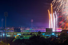
Mirpur 10 Night view
Education
- Monipur High School
- Model Academy
- Dhaka Commerce College
Bangladesh University of Business and Technology (BUBT)- BCIC College
- Bangladesh University of Professionals
Mirpur Bangla High School and College (MBHSC)
Sports
For the cricket world cup of 2011, Mirpur's Sher-e-Bangla Cricket Stadium was selected as a venue.[4] For this, renovations were carried out within the thana. The opening match was held there on 19 February 2011.
Sher-e-Bangla Cricket Stadium
See also
| Wikimedia Commons has media related to Mirpur, Dhaka. |
- Upazilas of Bangladesh
- Districts of Bangladesh
- Divisions of Bangladesh
References
^ Farooque, Md. Abu Hasan (2012). "Mirpur Model Thana". In Islam, Sirajul; Jamal, Ahmed A. Banglapedia: National Encyclopedia of Bangladesh (Second ed.). Asiatic Society of Bangladesh..mw-parser-output cite.citation{font-style:inherit}.mw-parser-output .citation q{quotes:"""""""'""'"}.mw-parser-output .citation .cs1-lock-free a{background:url("//upload.wikimedia.org/wikipedia/commons/thumb/6/65/Lock-green.svg/9px-Lock-green.svg.png")no-repeat;background-position:right .1em center}.mw-parser-output .citation .cs1-lock-limited a,.mw-parser-output .citation .cs1-lock-registration a{background:url("//upload.wikimedia.org/wikipedia/commons/thumb/d/d6/Lock-gray-alt-2.svg/9px-Lock-gray-alt-2.svg.png")no-repeat;background-position:right .1em center}.mw-parser-output .citation .cs1-lock-subscription a{background:url("//upload.wikimedia.org/wikipedia/commons/thumb/a/aa/Lock-red-alt-2.svg/9px-Lock-red-alt-2.svg.png")no-repeat;background-position:right .1em center}.mw-parser-output .cs1-subscription,.mw-parser-output .cs1-registration{color:#555}.mw-parser-output .cs1-subscription span,.mw-parser-output .cs1-registration span{border-bottom:1px dotted;cursor:help}.mw-parser-output .cs1-ws-icon a{background:url("//upload.wikimedia.org/wikipedia/commons/thumb/4/4c/Wikisource-logo.svg/12px-Wikisource-logo.svg.png")no-repeat;background-position:right .1em center}.mw-parser-output code.cs1-code{color:inherit;background:inherit;border:inherit;padding:inherit}.mw-parser-output .cs1-hidden-error{display:none;font-size:100%}.mw-parser-output .cs1-visible-error{font-size:100%}.mw-parser-output .cs1-maint{display:none;color:#33aa33;margin-left:0.3em}.mw-parser-output .cs1-subscription,.mw-parser-output .cs1-registration,.mw-parser-output .cs1-format{font-size:95%}.mw-parser-output .cs1-kern-left,.mw-parser-output .cs1-kern-wl-left{padding-left:0.2em}.mw-parser-output .cs1-kern-right,.mw-parser-output .cs1-kern-wl-right{padding-right:0.2em}
^ 2000 Census of Bangladesh
^ "Population Census Wing, BBS". Archived from the original on March 27, 2005. Retrieved November 10, 2006.
^ Mirpur Host 6 ODI matches


