Ørland
Ørland kommune | |||
|---|---|---|---|
Municipality | |||
 View of the shoreline of Ørland | |||
| |||
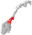
 Ørland within Trøndelag | |||
| Coordinates: 63°42′32″N 09°36′38″E / 63.70889°N 9.61056°E / 63.70889; 9.61056Coordinates: 63°42′32″N 09°36′38″E / 63.70889°N 9.61056°E / 63.70889; 9.61056 | |||
| Country | Norway | ||
| County | Trøndelag | ||
| District | Fosen | ||
| Established | 1 Jan 1838 | ||
| Administrative centre | Brekstad | ||
| Government | |||
| • Mayor (2015) | Tom Myrvold (H) | ||
| Area | |||
| • Total | 73.18 km2 (28.25 sq mi) | ||
| • Land | 73.09 km2 (28.22 sq mi) | ||
| • Water | 0.09 km2 (0.03 sq mi) 0.1% | ||
| Area rank | #395 in Norway | ||
| Population (2017) | |||
| • Total | 5,291 | ||
| • Rank | #193 in Norway | ||
| • Density | 72.4/km2 (188/sq mi) | ||
| • Change (10 years) | 3.9% | ||
| Demonym(s) | Ørlending[1] | ||
| Time zone | UTC+01:00 (CET) | ||
| • Summer (DST) | UTC+02:00 (CEST) | ||
| ISO 3166 code | NO-5015 | ||
| Official language form | Bokmål | ||
| Website | orland.kommune.no | ||
Data from Statistics Norway | |||

Ørland is a municipality in Trøndelag county, Norway. It is part of the Fosen region. Ørland is located at the southwestern tip of the Fosen peninsula at the northern shore of the mouth of Trondheimsfjord where the Stjørnfjorden arm begins. The administrative centre of the municipality is the city of Brekstad, which declared itself to be a city in 2005. Some of the villages in Ørland include Uthaug, Opphaug, and Ottersbo.
The 73-square-kilometre (28 sq mi) municipality is the 395th largest by area out of the 422 municipalities in Norway. Ørland is the 193rd most populous municipality in Norway with a population of 5,291. The municipality's population density is 72.4 inhabitants per square kilometre (188/sq mi) and its population has increased by 3.9% over the last decade.[2]
Contents
1 General information
1.1 Name
1.2 Coat of arms
1.3 Churches
2 Geography
2.1 Climate
3 Government
3.1 Municipal council
4 Economy
5 Transportation and communication
6 Education and health services
7 Attractions
8 History
9 Sister Cities
10 Media gallery
11 References
12 External links
General information

Map of Ørland
The municipality of Ørland was established on 1 January 1838 (see formannskapsdistrikt). In 1853, the northern district of Bjugn was separated to become a municipality of its own. This left Ørland with 3,361 residents. On 1 January 1896, the southern district of Værnes was separated from Ørland to become the municipality of Agdenes. After the division, Ørland had 3,649 residents and it was just a fraction of its original size.[3]
On 1 January 2018, the municipality switched from the old Sør-Trøndelag county to the new Trøndelag county.
On 1 January 2020, the municipalities of Ørland and Bjugn will merge to form a new municipality called Ørland with its administrative centre located at Botngård.[4]
Name
The Old Norse form of the name was Yrjar. This is a plural form derived from aurr which means "gravel". The last element land was added in the 16th century (spelled "Ørieland" in 1590).[5]
Coat of arms
The coat of arms is from modern times. They were granted on 9 February 1979. The arms are derived from the arms of Inger, Lady of Austraat, a noblewoman who lived in Austrått manor, Ørland from 1488–1555 and who played a major role in the history of the area. She was later portrayed by Henrik Ibsen in his play Lady Inger of Ostrat.[6]
Churches
The Church of Norway has one parish (sokn) within the municipality of Ørland. It is part of the Fosen prosti (deanery) in the Diocese of Nidaros.
| Parish (Sokn) | Church Name | Location of the Church | Year Built |
|---|---|---|---|
| Ørland | Ørland Church | Brekstad | 1342 |
| Storfosna Church | Storfosna | 1915 |
Geography

Ørland is coastal lowland
Ørland is largely flat lowland, and rather windy as it faces the Norwegian Sea to the west with the Trondheimsfjord and the mouth of the Stjørnfjord to the east. Ørland's topography differs markedly from most other areas in Norway. Only 2% of the municipality exceeds an altitude of 160 metres (520 ft) above sea level. Ørland consists of wide open spaces mainly used by Norway's main air force base, agriculture, nature conservation areas and residential neighborhoods. The municipality also includes three inhabited islands (Garten, Kråkvåg and Storfosna) as well as many islets. The Kjeungskjær lighthouse lies at the mouth of the Bjugnfjorden in the northeastern part of the municipality.
The highest peak, Osplikammen at 285 metres (935 ft) above sea level, is located within Rusaset that forms a mountainous area in the eastern parts of the municipality. Fosenheia, a peak south of Storfosna, is also highly visible in the landscape.
The Convention on Wetlands, called the Ramsar Convention, is an intergovernmental treaty that provides the framework for national action and international cooperation for the conservation and wise use of wetlands and their resources. Ørland has four Ramsar areas: Grandefjæra nature conservancy, and the wildlife protection areas of Hovsfjæra, Innstrandfjæra, and Kråkvågsvaet, all of which are significant for seabirds, wading birds and migratory birds. The area around Rusasetvatnet is important for bird life. Austråttlunden landscape conservancy also has protected status.
Climate
Ørland has a mild, albeit at times windy, climate. The mean annual temperature is 5.8 °C (42.4 °F) (1961–90, recent years have generally been warmer) and mean annual precipitation is 1,048 millimetres (41.3 in).[7] The prevailing wind direction is from the southwest, a wind sometimes accompanied by precipitation. Snow rarely remains after 3–4 days in the city of Brekstad and other coastal areas of the municipality. However, in the eastern parts of the municipality the snow remains longer making possible skiing and other winter activities at the lighted track near the Yrjar ski cabin.
| Ørland | ||||||||||||||||||||||||||||||||||||||||||||||||||||||||||||
|---|---|---|---|---|---|---|---|---|---|---|---|---|---|---|---|---|---|---|---|---|---|---|---|---|---|---|---|---|---|---|---|---|---|---|---|---|---|---|---|---|---|---|---|---|---|---|---|---|---|---|---|---|---|---|---|---|---|---|---|---|
| Climate chart (explanation) | ||||||||||||||||||||||||||||||||||||||||||||||||||||||||||||
| ||||||||||||||||||||||||||||||||||||||||||||||||||||||||||||
| ||||||||||||||||||||||||||||||||||||||||||||||||||||||||||||
Government
All municipalities in Norway, including Ørland, are responsible for primary education (through 10th grade), outpatient health services, senior citizen services, unemployment and other social services, zoning, economic development, and municipal roads. The municipality is governed by a municipal council of elected representatives, which in turn elect a mayor. The municipality falls under the Fosen District Court and the Frostating Court of Appeal.
Municipal council
The municipal council (Kommunestyre) of Ørland is made up of 25 representatives that are elected to four year terms. Currently, the party breakdown is as follows:[8]
| Party Name | Name in Norwegian | Number of representatives | |
|---|---|---|---|
| Labour Party | Arbeiderpartiet | 5 | |
| Progress Party | Fremskrittspartiet | 1 | |
| Conservative Party | Høyre | 10 | |
| Centre Party | Senterpartiet | 7 | |
| Socialist Left Party | Sosialistisk Venstreparti | 1 | |
| Liberal Party | Venstre | 1 | |
| Total number of members: | 25 | ||
Economy
Major occupations are the Ørland Air Base, part of the Royal Norwegian Air Force; agriculture; industry, public services; and commerce.
The largest employer of the Fosen peninsula is the military air force base located in Ørland municipality. In 2013 about 650 employees and 254 drafted soldiers worked at the base. With the upgrade of the base it is estimated that the base will have 1070 employees and 565 drafted soldiers in 2020. Ørland hovedflystasjon is currently one of two main air force bases in Norway. The Norwegian parliament decided in 2012 to concentrate most of fighter planes at one base: Ørland. The base is currently in the process of upgrading to be able to operate Norway's new fighter jet—the F-35 Joint Strike Fighter. 52 planes are to be acquired from Lockheed Martin, most of which will be stationed in Ørland. Ørland is also operating Westland Sea King search and rescue helicopters as well as being a forward operations location of NATO's surveillance plane the E-3/AWACS. The Norwegian F-16 Immediate Reaction Force is stationed at Ørland along with support and administration.
Mascot Høie, established in 1986, is the largest industrial employer in the municipality. The company produces duvets, pillows, blankets duvet covers and bed linens. Headquarters are located in Brekstad, Ørland and employs about 100.
Grøntvedt Pelagic, established in 1988, employs around 100 and processes herring, mackerel and other pelagic species in their factories in Uthaug and Kråkvåg. The company is the world's largest producer of barrel-marinated herring.
In 2010 agriculture employed about 8% of the population of Ørland and the sector is dominating the landscape of Ørland. The most important products were milk, grain and meat. Ørland Cheese and Milk Factory closed its doors in 2011. Ørland Savings Bank was established in 1849, only 26 years after the first of its kind in Norway (in Christiania). The bank is an independent bank, but is part of Eika-Gruppen.
Ørland is a regional center for both shopping and business services. In the city of Brekstad shoppers can visit and enjoy several clothing stores, grocery stores, cafes, lumber, and hardware stores, goldsmiths, flower shop, convenience stores, sports stores, gift stores, restaurants, optometry store, health food store, drug store, Asian grocery store, bookshop, banks, office supply, pet supplies, paint store, art galleries, furniture store, bakeries, car dealers and liquor store.
Business services like accountants, attorneys, banks, consultants, advertising agencies, office supplies, auditing, print shops, collection agency and office services are readily available.
Transportation and communication
Passenger ferries run between Brekstad and Trondheim eight times each direction on weekdays (reduced service on weekends). This makes commuting convenient and many commute to and from Trondheim for work or studies on a daily basis. Several employees of the air force live outside of Ørland. There is a daily weekday average of about 900 passengers – 400 of which travels to or from Hitra/Frøya or Kristiansund.
Automobile ferry service connects Brekstad to Valset in Agdenes municipality. This connection is a part of Norwegian County Road 710 (Fv 710) from Orkanger to Krinsvatn. On weekdays the ferry departs every 30 minutes during rush hour; hourly the rest of the day.
Air Norway is an airline owned by Ørland municipality, Nordic Air AS and North Flying AS. The company operates direct flights between Ørland and Oslo Airport, Gardermoen as well continuation of flight to Aalborg, Denmark.
In 1923, the island of Garten was connected to the mainland by bridge. The bridge between the two islands of Storfosna and Kråkvåg opened in 2003. A ferry connects Garten to Storfosna. The ferry also connects Garten and Storfosna with Leksa and Værnes in Agdenes municipality across the Trondheim Fjord.
Good electronic communications is available via fiber network to most residents in Brekstad and the towns of Uthaug and Opphaug while ADSL/VDSL is available everywhere else. Mobile G4 service is available in most of Ørland.
Education and health services
The municipality has two recently renovated public primary schools: Opphaug skole (which serves the villages of Opphaug, Ottersbo and Uthaug) and Hårberg skole (which serves the city of Brekstad as well as the villages of Beian, Garten, Grande, Kråkvåg, Rønne, and Storfosna). A new primary school in Brekstad is planned completed by the school year starting in 2017. Middle school kids attend a school renovated in 2009: Ørland ungdomsskole in Brekstad. Most high school students attend Fosen videregående skole in nearby Botngård.
For preschool children, the municipality offers services at Futura and Borgen childcare centers. The private childcare centers Marihøna Music and Outdoors childcare center, Teletun Nature- and Farm childcare center and Solblomsten Steiner childcare center.
The municipal health services are located in Ørland Medical Center (Ørland Medisinske Senter)/ Fosen Helse IKS/Fosen DMS. The center has developed from being a health clinic and birthing center founded and run by the Norwegian Women's Public Health Association (N.K.S) to a health care center that offers a wide range of services. The municipality has one of the largest offering within decentralized health services in Norway: emergency room, health promotion and disease prevention center, cancer coordinators, mental health services, psychologist, X-ray services, dermatologist, phototherapy, endocrinology (stomach and intestinal diseases), otorhinolaryngology (ear, nose and throat), gynecology, surgery, orthopedics. In addition, the center offers services such as specialized rehabilitation, ambulance, midwife and ophthalmologist.
Attractions
Major attractions are the Ramsar Convention Bird Protection areas, the coastal areas themselves, and the Manor of Austrått, dated 1656 and with a known history from around 1000 AD. Other attractions are the single, large Sessile oak (the northernmost in the world, known as Austråtteika) in the nearby forest;[9] and the fortifications of the triple 28-centimetre (11 in) gun turret from World War II, which is now open to public viewing.
History
Archaeological digs has shown that Ørland has been a regional center at least starting at the Iron Age. One of the longhouses found has a unique structure, believed to have served a special purpose, for example a court, customs house or assembly hall. Excavation ongoing as of 2015[update] for expansion of the airport revealed post holes for long houses and a large midden (rubbish pile), giving detailed information about how the inhabitants lived.[10]
A hillfort from the Migration Period (about 500 A.D.) similarly shows that there must have been something to defend in the area. The hillfort is located on Borgklinten, east of Ottersbo and Austrått. Due to Ørlands geographical location at the entrance of the Trondheim fjord it must have been a strategically important place for the exercise of power or to control trade.
Austrått Manor is the municipality's most important historical building. Austrått has been the site of a manor or royal estate since about 1000 A.D. and several historical figures have been associated with the place. At the time of the Battle of Stiklestad, Finn Árnasson was lord of Austrått. His wife was Bergljot (Bergljót Halvdansdóttir), niece of Kings Harald Hardrada and Olaf II of Norway. Finn's daughter Ingibiorg Finnsdottir became the wife of Thorfinn, earl of the Orkney Islands.[11]
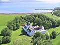
Lady Inger of Austrått (1473-1555) was at the time Norway's most prominent woman. Through inheritance, use of force and other methods Lady Inger increased her wealth and controlled vast land areas. After the death of her husband, Niels Henrikssøn (ca. 1458–1523), she had strong political and economical influence. Henrik Ibsen's romantic portrayal of her as an idealistic freedom fighter is probably not accurate. It is believed that Lady Inger and Niels started what later Ove Bjelke completed: the Austrått Manor. Ove Bjelke (1611–1674) built Austrått Manor the way we see it today. It is a manor with a sense of symmetry and symbols of power and inspired by the builder's time as a student in Italy. The complex, which was built around a church from the Middle Ages, was probably completed around 1656. The manor was consumed by a fire in 1916, but was later restored—a process which was completed in 1961.
Storfosen Manor (Storfosen Gods) also has a long history dating at least as far back as the 12th century. This manor was a royal estate in the 14th century, but was for the next 300 years part of the land holdings of the rulers at Austrått. Lady Inger lived here as a widow. The property is still amongst the biggest farms in the county. Ruins of a 14th-century chapel is located on the property. The manor changed hands in 2014; the new owners are developing the manor into a hotel.[12]
Uthaug Manor (Uthaugsgården) owned by the Lund family from 1829, developed throughout the 19th century to become a full-fledged trading company comprising trade in fish and other commodities as well as a guesthouse, post office, telegraph and a steamship terminal. The place is today occupied by Museet Uthaugsgården and is unique due to the preservation of many rooms and items in their original condition.[13]
At the same time Ørland was the center for a large coastal district with a district judge and tax collector. The district comprised the area from Hemne to Osen including islands to the west. Starting in 1837 the church parish and the municipality included what is today Ørland, Bjugn and the northern parts of Agdenes municipalities. The Savings bank, established in 1849, covered the same area. In 1853, Bjugn incorporated as a separate municipality. Ørland got its present-day shape and size when Agdenes incorporated into its own municipality in 1896.
The people of Ørland has for generations made their living as coastal farmers who combined farming, coastal fishing, and seasonal work at the fishing grounds further out. Ørland has had its own cheese and milk factory since 1878 and a grain mill predating written records. Later fish processing has been part of the mix.
With the arrival of the 20th century came new problems and new opportunities. The German occupation was a boom time for workers who built the airport. The airport changed the landscape significantly. Several prison camps, in places like Austrått, Uthaug and Hovde, made a strong impression on the population leading to Fosen being a key area for Norwegian-Yugoslav relations. After the war, in 1954, the airport reopened as a NATO facility. The establishment of the airport the air force became a good opportunity for jobs and careers for the locals. As of 2016[update], the Ørland air force base is the biggest employer in the Fosen. The military employees are often in relationships where both partners have high income jobs.
Ørland had its own dairy school from 1894 to 2001, school of home economics since 1923 and vocational school since 1960. The latter two were merged into the Fosen videregående skole in 2000.
Sister Cities
Glendale, AZ, USA
and Koceljeva, Serbia
Media gallery

Austrått Fort, gun turret was taken from the German battleship Gneisenau.

Kjeungskjær lighthouse, which can be rented

Part of the Manor of Austrått (Austråttborgen).
Manor of Austrått and Trondheimsfjord.
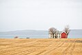
A farm in the characteristic flat landscape of Ørland


References
^ "Navn på steder og personer: Innbyggjarnamn" (in Norwegian). Språkrådet. Retrieved 2015-12-01..mw-parser-output cite.citation{font-style:inherit}.mw-parser-output .citation q{quotes:"""""""'""'"}.mw-parser-output .citation .cs1-lock-free a{background:url("//upload.wikimedia.org/wikipedia/commons/thumb/6/65/Lock-green.svg/9px-Lock-green.svg.png")no-repeat;background-position:right .1em center}.mw-parser-output .citation .cs1-lock-limited a,.mw-parser-output .citation .cs1-lock-registration a{background:url("//upload.wikimedia.org/wikipedia/commons/thumb/d/d6/Lock-gray-alt-2.svg/9px-Lock-gray-alt-2.svg.png")no-repeat;background-position:right .1em center}.mw-parser-output .citation .cs1-lock-subscription a{background:url("//upload.wikimedia.org/wikipedia/commons/thumb/a/aa/Lock-red-alt-2.svg/9px-Lock-red-alt-2.svg.png")no-repeat;background-position:right .1em center}.mw-parser-output .cs1-subscription,.mw-parser-output .cs1-registration{color:#555}.mw-parser-output .cs1-subscription span,.mw-parser-output .cs1-registration span{border-bottom:1px dotted;cursor:help}.mw-parser-output .cs1-ws-icon a{background:url("//upload.wikimedia.org/wikipedia/commons/thumb/4/4c/Wikisource-logo.svg/12px-Wikisource-logo.svg.png")no-repeat;background-position:right .1em center}.mw-parser-output code.cs1-code{color:inherit;background:inherit;border:inherit;padding:inherit}.mw-parser-output .cs1-hidden-error{display:none;font-size:100%}.mw-parser-output .cs1-visible-error{font-size:100%}.mw-parser-output .cs1-maint{display:none;color:#33aa33;margin-left:0.3em}.mw-parser-output .cs1-subscription,.mw-parser-output .cs1-registration,.mw-parser-output .cs1-format{font-size:95%}.mw-parser-output .cs1-kern-left,.mw-parser-output .cs1-kern-wl-left{padding-left:0.2em}.mw-parser-output .cs1-kern-right,.mw-parser-output .cs1-kern-wl-right{padding-right:0.2em}
^ Statistisk sentralbyrå (2017). "Table: 06913: Population 1 January and population changes during the calendar year (M)" (in Norwegian). Retrieved 2017-10-07.
^ Jukvam, Dag (1999). "Historisk oversikt over endringer i kommune- og fylkesinndelingen" (PDF) (in Norwegian). Statistisk sentralbyrå.
^ "Kommunesammenslåing mellom Bjugn og Ørland" (in Norwegian). Ørland kommune. Retrieved 2017-10-07.
^ Rygh, Oluf (1901). Norske gaardnavne: Søndre Trondhjems amt (in Norwegian) (14 ed.). Kristiania, Norge: W. C. Fabritius & sønners bogtrikkeri. p. 49.
^ "Civic heraldry of Norway - Norske Kommunevåpen". Heraldry of the World. Retrieved 2018-05-05.
^ "Ørland: 1961-1990 base period". met.no.
^ "Table: 04813: Members of the local councils, by party/electoral list at the Municipal Council election (M)" (in Norwegian). Statistics Norway. 2015.
^ "Austråttlunden" (PDF) (in Norwegian).
^ "1,500-year-old Viking settlement found beneath new Norwegian airport site". 2015. Retrieved 28 December 2015.
^ Bratberg, Terje, ed. (2017-01-30). "Austrått – herregård i Ørland". Store norske leksikon (in Norwegian). Kunnskapsforlaget. Retrieved 2017-10-07.
^ Morten Haugen. "Storfosen". Store norske leksikon. Retrieved February 1, 2017.
^ "Uthaugsgården". Trøndelag. Retrieved February 1, 2017.
External links
| Wikimedia Commons has media related to Ørland. |
 Trøndelag travel guide from Wikivoyage
Municipal fact sheet from Statistics Norway (in Norwegian)
Trøndelag county, Norway | |||||||||||||||||||||||||||||||||||||
|---|---|---|---|---|---|---|---|---|---|---|---|---|---|---|---|---|---|---|---|---|---|---|---|---|---|---|---|---|---|---|---|---|---|---|---|---|---|
 |
|  | |||||||||||||||||||||||||||||||||||
||
Authority control |
|
|---|


