Cundinamarca Department
This article includes a list of references, but its sources remain unclear because it has insufficient inline citations. (May 2016) (Learn how and when to remove this template message) |
Cundinamarca Department Departamento de Cundinamarca | |||
|---|---|---|---|
Department | |||
| |||
| Motto(s): Cundinamarca Corazón de Colombia (Spanish: Cundinamarca, Heart of Colombia) | |||
| Anthem: Himno de Cundinamarca | |||
 Cundinamarca and Bogotá are shown in red | |||
 Topography of the department | |||
| Coordinates: 4°36′N 74°5′W / 4.600°N 74.083°W / 4.600; -74.083Coordinates: 4°36′N 74°5′W / 4.600°N 74.083°W / 4.600; -74.083 | |||
| Country | |||
| Region | Andean Region | ||
| Established | June 15, 1857 | ||
| Capital | Bogotá | ||
| Government | |||
| • Governor | Jorge Emilio Rey Angel (2016-2019) | ||
| Area [1][2] | |||
| • Total | 22,623 km2 (8,735 sq mi) | ||
| Area rank | 17th | ||
| Population (2013)[3] | |||
| • Total | 2,680,041 | ||
| • Rank | 4th | ||
| • Density | 120/km2 (310/sq mi) | ||
| Time zone | UTC-05 | ||
| ISO 3166 code | CO-CUN | ||
| Provinces | 15 | ||
HDI (2017) | 0.756[4] high · 9th | ||
| Website | Official website | ||


Department of Cundinamarca (Departamento de Cundinamarca, Spanish pronunciation: [kundinaˈmaɾka]) is one of the departments of Colombia. Its area covers 22,623 square kilometres (8,735 sq mi) (not including the Capital District) and it has a population of 2,598,245 as of 2013. It was created on August 5, 1886 under the constitutional terms presented on the same year. Cundinamarca is located in the center of Colombia.
Cundinamarca's capital city is Bogotá, the capital of Colombia. This is a special case among Colombian departments, since Bogotá is not legally a part of Cundinamarca, yet it is the only department that has its capital designated by the Constitution (if the capital were to be ever moved, it would take a constitutional reform to do so, instead of a simple ordinance passed by the Cundinamarca Assembly). In censuses, the populations for Bogotá and Cundinamarca are tabulated separately; otherwise, Cundinamarca's population would total over 10 million.
| Entity | Population | Area (km²) | Area (square miles) | Density (per km²) | Density (per sq.mi.) |
|---|---|---|---|---|---|
Cundinamarca (without Bogotá) | 2,349,578 | 22,623 | 8,735 | 104 | 269 |
| Bogotá | 7,881,156 | 1,587 | 613 | 4,966 | 12,857 |
| Cundinamarca and Bogotá | 10,230,734 | 24,210 | 9,348 | 423 | 1,094 |
Contents
1 Etymology
2 Geography
3 Demography and ethnography
3.1 Municipalities with over 50,000 inhabitants
3.1.1 Municipal population position
3.1.2 Important cities
4 Provinces
5 Sports
6 See also
7 References
8 External links
Etymology
The name of Cundinamarca comes from Kuntur marqa, an indigenous expression, probably derived from Muisca and means "condor's nest", it was used in pre-Columbian times by the natives of the Magdalena Valley to refer to the nearby highlands.[5][6][7]
Geography
Most of Cundinamarca is on the Eastern Cordillera (Cordillera Oriental), just south of Boyacá, bordered by the Magdalena River on the west, reaching down into the Orinoco River basin on the east, and bordering on Tolima to the south. The capital district of Bogotá is nearly completely surrounded by Cundinamarca territory and was formed by carving up Cundinamarca. Because of this and other border changes, the present department of Cundinamarca is much smaller than the original state.
Demography and ethnography
Municipalities with over 50,000 inhabitants
Municipal population position
| Rank | City or municipality | Inhabitants (1985) | Inhabitants (1993) | Inhabitants (2005) | Inhabitants (2015)* | Inhabitants (2020)* |
|---|---|---|---|---|---|---|
| 1 | Soacha | 132,758 | 254,625 | 401,996 | 511,262 | 567,546 |
| 2 | Fusagasugá | 63,886 | 82,003 | 108,949 | 134,523 | 147,631 |
| 3 | Facatativá | 55,324 | 75,711 | 107,463 | 132,106 | 144,149 |
| 4 | Zipaquirá | 60,202 | 75,166 | 101,562 | 122,347 | 132,419 |
| 5 | Chía | 38,862 | 55,742 | 97,907 | 126,647 | 141,917 |
| 6 | Girardot | 81,019 | 90,904 | 97,889 | 105,085 | 107,796 |
| 7 | Mosquera | 16,505 | 22,250 | 63,237 | 82,750 | 93,461 |
| 8 | Madrid | 33,795 | 42,584 | 62,436 | 77,627 | 85,090 |
| 9 | Funza | 31,366 | 41,119 | 61,391 | 75,350 | 82,321 |
| 10 | Cajicá | 23,618 | 31,316 | 45,391 | 56,875 | 62,713 |
Source: DANE *projection[8] | ||||||
According to the latest census conducted in 2005, 2,280,037 people live in Cundinamarca, excluding 6,776,009 of the capital, Bogotá. The racial makeup is:
- Whites and mestizos (96.28%): Mestizos are mixed European-Amerindian blood. The Bogotá metropolitan area has a history of European (not limited to Spanish) and other Latin American immigration.
- Blacks or Afro-Colombians (3.33-3.37%)
- Indigenous/Amerindians (0.31-0.34%)
Roma (Gitanos or Gypsies) (0.01%)
East Asians (0.01%), often of Chinese descent. About 25,000 Chinese-Colombians live in the department.
The city of Bogotá and the municipalities of Soacha, La Calera, Cota, Chía, Madrid, Funza, Mosquera, Fusagasugá, Facatativá and Zipaquirá form a single metropolitan area.
Important cities
Cundinamarca is made up of 116 municipalities, six of which recorded a population of over 100,000 and could be considered as cities: Soacha, Fusagasugá, Girardot, Facatativá, Zipaquirá and Chia, while Bogotá District is in the category of capital.
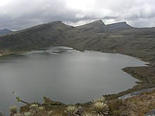
Chisaca Lake on the Sumapaz Paramo
Bogotá Metropolitan Area: Comprises the towns of Soacha, Facatativá, Chia, Madrid, Funza, and Mosquera, among others. Its activities are centered in the industrial sector. Estate activity is important especially in the suburbs closer to Bogotá: Chía, La Calera and Tocancipá.
Girardot: In the far southwest and bordering Department of Tolima, is the capital of the Province of Alto Magdalena. Its main economic activity is trade, as a result of a major tourist dynamics and its proximity to major agricultural areas of Tolima. It has a college and important trade fairs and events.
Fusagasugá is located between Bogotá and Girardot, and it is an hour of each city. The capital city of the Province of Sumapaz, it is an important focus of agricultural marketing and regional services, standing out as an educational city with a large university and an increasing population trend. Its economy is mainly focused on trade and agricultural marketing, with a significant production of ornamental plants and flowers for export, for which it is known as the garden city of Colombia.
Zipaquirá: Despite being part of the metropolitan area of Bogotá, it has managed to position itself as one of the most important centers of Colombia's salt mining industry. Its economy is focused on commerce and services.
Other major towns are Ubaté due to high livestock and dairy production. Guaduas, is an important cultural center. Chocontá and Fred are agricultural centers.
Provinces
Cundinamarca has 15 provinces and the Capital District (Bogotá), which simultaneously acts as capital of the Republic, capital of the Department and a separately administered District (or Department) in itself.

Subachoque valley in Western Savanna Province
- Almeidas
- Upper Magdalena (Alto Magdalena)
- Lower Magdalena (Bajo Magdalena)
- Gualivá
- Guavio
- Central Magdalena (Magdalena Centro)
- Medina
- Eastern (Oriente)
- Rionegro
- Central Savanna (Sabana Centro)
- Western Savanna (Sabana Occidente)
- Soacha
- Sumapaz
- Tequendama
- Ubaté
Sports
The department is home to the basketball team Cóndores de Cundinamarca, which plays its home games in the Coliseo de la Luna in Chía.
See also
- Postage stamps of Cundinamarca
- Altiplano Cundiboyacense
References
^ "Departamento: Datos generales: Límites" (in Spanish). Gobernación del Cundinamarca. Archived from the original on 24 January 2013..mw-parser-output cite.citation{font-style:inherit}.mw-parser-output .citation q{quotes:"""""""'""'"}.mw-parser-output .citation .cs1-lock-free a{background:url("//upload.wikimedia.org/wikipedia/commons/thumb/6/65/Lock-green.svg/9px-Lock-green.svg.png")no-repeat;background-position:right .1em center}.mw-parser-output .citation .cs1-lock-limited a,.mw-parser-output .citation .cs1-lock-registration a{background:url("//upload.wikimedia.org/wikipedia/commons/thumb/d/d6/Lock-gray-alt-2.svg/9px-Lock-gray-alt-2.svg.png")no-repeat;background-position:right .1em center}.mw-parser-output .citation .cs1-lock-subscription a{background:url("//upload.wikimedia.org/wikipedia/commons/thumb/a/aa/Lock-red-alt-2.svg/9px-Lock-red-alt-2.svg.png")no-repeat;background-position:right .1em center}.mw-parser-output .cs1-subscription,.mw-parser-output .cs1-registration{color:#555}.mw-parser-output .cs1-subscription span,.mw-parser-output .cs1-registration span{border-bottom:1px dotted;cursor:help}.mw-parser-output .cs1-ws-icon a{background:url("//upload.wikimedia.org/wikipedia/commons/thumb/4/4c/Wikisource-logo.svg/12px-Wikisource-logo.svg.png")no-repeat;background-position:right .1em center}.mw-parser-output code.cs1-code{color:inherit;background:inherit;border:inherit;padding:inherit}.mw-parser-output .cs1-hidden-error{display:none;font-size:100%}.mw-parser-output .cs1-visible-error{font-size:100%}.mw-parser-output .cs1-maint{display:none;color:#33aa33;margin-left:0.3em}.mw-parser-output .cs1-subscription,.mw-parser-output .cs1-registration,.mw-parser-output .cs1-format{font-size:95%}.mw-parser-output .cs1-kern-left,.mw-parser-output .cs1-kern-wl-left{padding-left:0.2em}.mw-parser-output .cs1-kern-right,.mw-parser-output .cs1-kern-wl-right{padding-right:0.2em}
^ Kline, Harvey F. (2012). "Cundinamarca, Department of". Historical Dictionary of Colombia. Scarecrow Press. p. 157. ISBN 978-0-8108-7813-6.
^ "DANE". Archived from the original on November 13, 2009. Retrieved February 13, 2013.
^ "Sub-national HDI - Area Database - Global Data Lab". hdi.globaldatalab.org. Retrieved 2018-09-13.
^ Diccionario de la Lengua Española. http://dle.rae.es/?id=OMLt42i%7COMn573a Consulta el 24-05-2015.
^ Diccionario de la Lengua Española. http://dle.rae.es/?id=OT28kUW Consulta el 24-05-2015.
^ Acosta, Joaquín (1848). "Extensión y limites del territorio de los Chibchas ó Muíscas". Compendio Histórico-Descubrimiento y colonización de la Nueva Granada en el siglo décimo-sexto (in Spanish). Biblioteca Virtual de la Biblioteca Luis Ángel Arango. Retrieved 18 April 2012.
^ Projections 1985-2020. Bogotá: DANE. 12 May 2011. Retrieved 30 July 2015.
External links
| Wikimedia Commons has media related to Cundinamarca Department. |
| Wikivoyage has a travel guide for Cundinamarca. |
"Gobernación de Cundinamarca: Perfiles (Cundinamarca Government Profiles)" (in Spanish). Gobernación del Cundinamarca. Archived from the original on 2013-01-15.
Departments of Colombia | ||||||||
|---|---|---|---|---|---|---|---|---|
 |
| |||||||
Provinces and Municipalities in Cundinamarca Department | |
|---|---|
| Almeidas Province |
|
| Upper Magdalena Province |
|
| Lower Magdalena Province |
|
| Gualivá Province |
|
| Guavio Province |
|
| Central Magdalena Province |
|
| Medina Province |
|
| Eastern Province |
|
| Rionegro Province |
|
| Central Savanna Province |
|
| Western Savanna Province |
|
| Soacha Province |
|
| Sumapaz Province |
|
| Tequendama Province |
|
| Ubaté Province |
|
| Metropolitan Area of Bogotá |
|


