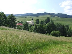
Stráňany
Stráňany | |
|---|---|
Village | |
 | |
 Stráňany Location of Stráňany in Slovakia | |
| Coordinates: 49°22′N 20°32′E / 49.367°N 20.533°E / 49.367; 20.533Coordinates: 49°22′N 20°32′E / 49.367°N 20.533°E / 49.367; 20.533 | |
| Country | Slovakia |
| Region | Prešov |
| District | Stará Ľubovňa |
| First mentioned | 1343 |
| Area | |
| • Total | 11.607 km2 (4.481 sq mi) |
| Elevation | 650 m (2,130 ft) |
| Population | |
| • Total | 194 |
| • Density | 17/km2 (43/sq mi) |
| Website | http://www.stranany.sk/ |
Stráňany (previously until 1948 Folvark, Hungarian: Nagymajor, Polish: Folwark, Rusyn: Страняны) is a village and municipality in Stará Ľubovňa District in the Prešov Region of northern Slovakia. The village is traditionally inhabited by Rusyns, as one of their westernmost settlements. There is Greek Catholic church built in 1857.
Contents
1 History
2 Geography
3 References
4 External links
History
In historical records the village was first mentioned in 1343. Initially it was a hamlet of Veľký Lipník with a folvark (hence the name prior to 1948). Around 1567 Vlachs settled here, who would later become Rusyns.[1]
Geography
The municipality lies at an altitude of 650 metres and covers an area of 11.607 km². It has a population of about 194 people.
References
^ Józef Nyka (2010). Pieniny. Przewodnik. Latchorzew. p. 60. ISBN 978-83-60078-09-9..mw-parser-output cite.citation{font-style:inherit}.mw-parser-output q{quotes:"""""""'""'"}.mw-parser-output code.cs1-code{color:inherit;background:inherit;border:inherit;padding:inherit}.mw-parser-output .cs1-lock-free a{background:url("//upload.wikimedia.org/wikipedia/commons/thumb/6/65/Lock-green.svg/9px-Lock-green.svg.png")no-repeat;background-position:right .1em center}.mw-parser-output .cs1-lock-limited a,.mw-parser-output .cs1-lock-registration a{background:url("//upload.wikimedia.org/wikipedia/commons/thumb/d/d6/Lock-gray-alt-2.svg/9px-Lock-gray-alt-2.svg.png")no-repeat;background-position:right .1em center}.mw-parser-output .cs1-lock-subscription a{background:url("//upload.wikimedia.org/wikipedia/commons/thumb/a/aa/Lock-red-alt-2.svg/9px-Lock-red-alt-2.svg.png")no-repeat;background-position:right .1em center}.mw-parser-output .cs1-subscription,.mw-parser-output .cs1-registration{color:#555}.mw-parser-output .cs1-subscription span,.mw-parser-output .cs1-registration span{border-bottom:1px dotted;cursor:help}.mw-parser-output .cs1-hidden-error{display:none;font-size:100%}.mw-parser-output .cs1-visible-error{font-size:100%}.mw-parser-output .cs1-subscription,.mw-parser-output .cs1-registration,.mw-parser-output .cs1-format{font-size:95%}.mw-parser-output .cs1-kern-left,.mw-parser-output .cs1-kern-wl-left{padding-left:0.2em}.mw-parser-output .cs1-kern-right,.mw-parser-output .cs1-kern-wl-right{padding-right:0.2em}
External links
- http://www.statistics.sk/mosmis/eng/run.html
This Prešov Region geography article is a stub. You can help Wikipedia by expanding it. |