Chimborazo Province
Chimborazo | |
|---|---|
Province | |
| Province of Chimborazo | |
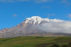 Chimborazo volcano | |
 Flag  Seal | |
 Chimborazo Province in Ecuador | |
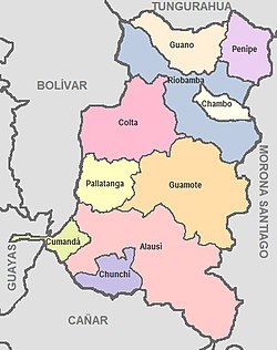 Cantons of Chimborazo Province | |
| Country | Ecuador |
| Legal establishment | June 25, 1826 |
| Capital | Riobamba |
| Cantons | List of cantons
|
| Government | |
| • Provincial Prefect | Mariano Curicama (Pachakutik) |
| Area | |
| • Total | 6,499.72 km2 (2,509.56 sq mi) |
| Population (2010 census) | |
| • Total | 458,581 |
| • Density | 71/km2 (180/sq mi) |
| Time zone | UTC-5 (ECT) |
| Vehicle registration | H |
HDI (2017) | 0.718[1] high · 16th |
| Website | www.chimborazo.gov.ec |
Chimborazo (Spanish pronunciation: [tʃimboˈɾaso]) is a province in the central Ecuadorian Andes. It is a home to a section of Sangay National Park. The capital is Riobamba. The province contains Chimborazo (6,267 m), Ecuador's highest mountain.
Contents
1 Cantons
2 Demographics
3 See also
4 References
5 External links
Cantons
The province is divided into 10 cantons. The following table lists each with its population at the time of the 2001 census, its area in square kilometres (km²), and the name of the canton seat or capital.[2]
| Canton | Pop. (2001) | Area (km²) | Seat/Capital |
|---|---|---|---|
| Alausí | 42,823 | 1,644 | Alausí |
| Chambo | 10,541 | 163 | Chambo |
| Chunchi | 12,474 | 273 | Chunchi |
| Colta | 44,701 | 829 | Cajabamba |
| Cumandá | 9,395 | 159 | Cumandá |
| Guamote | 35,210 | 1,216 | Guamote |
| Guano | 37,888 | 460 | Guano |
| Pallatanga | 10,800 | 377 | Pallatanga |
| Penipe | 6,485 | 370 | Penipe |
| Riobamba | 193,315 | 980 | Riobamba |
Town's in the province include Cacha.
Demographics
Ethnic groups as of the Ecuadorian census of 2010:[3]
Mestizo 58.4%
Indigenous 38.0%
White 2.2%
Afro-Ecuadorian 1.1%
Montubio 0.3%- Other 0.1%
See also
- Cantons of Ecuador
- Provinces of Ecuador
- Sangay National Park
- Opportunitas aequa
References
^ Villalba, Juan. "Human Development Index in Ecuador". Scribd (in Spanish). Retrieved 2019-02-05..mw-parser-output cite.citation{font-style:inherit}.mw-parser-output .citation q{quotes:"""""""'""'"}.mw-parser-output .citation .cs1-lock-free a{background:url("//upload.wikimedia.org/wikipedia/commons/thumb/6/65/Lock-green.svg/9px-Lock-green.svg.png")no-repeat;background-position:right .1em center}.mw-parser-output .citation .cs1-lock-limited a,.mw-parser-output .citation .cs1-lock-registration a{background:url("//upload.wikimedia.org/wikipedia/commons/thumb/d/d6/Lock-gray-alt-2.svg/9px-Lock-gray-alt-2.svg.png")no-repeat;background-position:right .1em center}.mw-parser-output .citation .cs1-lock-subscription a{background:url("//upload.wikimedia.org/wikipedia/commons/thumb/a/aa/Lock-red-alt-2.svg/9px-Lock-red-alt-2.svg.png")no-repeat;background-position:right .1em center}.mw-parser-output .cs1-subscription,.mw-parser-output .cs1-registration{color:#555}.mw-parser-output .cs1-subscription span,.mw-parser-output .cs1-registration span{border-bottom:1px dotted;cursor:help}.mw-parser-output .cs1-ws-icon a{background:url("//upload.wikimedia.org/wikipedia/commons/thumb/4/4c/Wikisource-logo.svg/12px-Wikisource-logo.svg.png")no-repeat;background-position:right .1em center}.mw-parser-output code.cs1-code{color:inherit;background:inherit;border:inherit;padding:inherit}.mw-parser-output .cs1-hidden-error{display:none;font-size:100%}.mw-parser-output .cs1-visible-error{font-size:100%}.mw-parser-output .cs1-maint{display:none;color:#33aa33;margin-left:0.3em}.mw-parser-output .cs1-subscription,.mw-parser-output .cs1-registration,.mw-parser-output .cs1-format{font-size:95%}.mw-parser-output .cs1-kern-left,.mw-parser-output .cs1-kern-wl-left{padding-left:0.2em}.mw-parser-output .cs1-kern-right,.mw-parser-output .cs1-kern-wl-right{padding-right:0.2em}
^ Cantons of Ecuador. Statoids.com. Retrieved 4 November 2009.
^ [1]
External links
| Wikimedia Commons has media related to Chimborazo Province. |
(in Spanish) Gobierno de la Provincia de Chimborazo, official website
(in Spanish) Radio Mundial Riobamba
- Chimborazo area map
|
Coordinates: 1°40′S 78°39′W / 1.667°S 78.650°W / -1.667; -78.650
This Ecuador location article is a stub. You can help Wikipedia by expanding it. |


