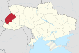
Lviv Oblast
Lviv Oblast Львівська область L’vivs’ka oblast’ | |
|---|---|
Oblast | |
 Flag  Coat of arms | |
| Nickname(s): Львівщина (Lvivshchyna) | |
 | |
| Country | |
| Administrative center | Lviv |
| Government | |
| • Governor | Oleh Syniutka |
| • Chairperson | Petro Kolodij |
| Area | |
| • Total | 21,833 km2 (8,430 sq mi) |
| Area rank | Ranked 17th |
| Population (2016) | |
| • Total | |
| Time zone | UTC+2 (EET) |
| • Summer (DST) | UTC+3 (EEST) |
| Area code | +380-32 |
| ISO 3166 code | UA-46 |
| Raions | 20 |
Cities (total) | 44 |
| • Regional cities | 9 |
| Urban-type settlements | 34 |
| Villages | 1849 |
| FIPS 10-4 | UP15 |
| Website | www.loda.gov.ua |
Lviv Oblast (Ukrainian: Львівська область, translit. L’vivs’ka oblast’; also referred to as L’vivshchyna, Ukrainian: Львівщина) is an oblast (province) in western Ukraine. The administrative center of the oblast is the city of Lviv. Population: 2,534,174 (2016 est.)[1].
Contents
1 History
2 Geography
3 Climate
4 Politics
4.1 Governors
5 Subdivisions
6 Demographics
6.1 Age structure
6.2 Median age
7 Religion
8 Historical and cultural sites
8.1 Gallery
9 Nomenclature
10 See also
11 References
12 External links
History
The oblast was created as part of the Ukrainian Soviet Socialist Republic on December 4, 1939 following the Soviet invasion of Poland. The territory of the former Drohobych Oblast was incorporated into the Lviv Oblast in 1959.
The oblast's strategic position at the heart of central Europe and as the gateway to the Carpathians has caused it to change hands many times over the centuries. It was ruled variously by Great Moravia, Kievan Rus', Poland, was independent as the state of Galicia-Volhynia (circa 1200 to 1340), and then ruled by the Polish–Lithuanian Commonwealth (1340 to 1772), the Austro-Hungarian Empire (1772 to 1918), West Ukrainian People's Republic and Poland (1919 to 1939), when it was part of the Lwów Voivodeship of the Second Republic of Poland. The region's historically dominant Ukrainian population declared the area to be a part of an independent West Ukrainian National Republic in November 1918 — June 1919, but this endured only briefly. Local autonomy was provided in international treaties but later on those were not honoured by the Polish government and the area experienced much ethnic tension between the Polish and Ukrainian population.
The region and its capital city take their name from the time of Galicia-Volhynia, when Daniel of Galicia, the King of Rus', founded Lviv; naming the city after his son, Leo. During this time, the general region around Lviv was known as Red Ruthenia (Cherven' Rus').
The region only became part of the Soviet Union under the terms of the Molotov–Ribbentrop Pact in 1939, when it was annexed to the Ukrainian SSR. It was occupied by Nazi Germany from 1941 to 1944, when almost all local Jews were killed,[citation needed] and remained in Soviet hands after World War II as was arranged during the Teheran and Yalta conferences. Local Poles were expelled and Ukrainians expelled from Poland arrived. Given its historical development, Lviv Oblast is one of the least Russified and Sovietized parts of Ukraine, with much of its Polish and Habsburg heritage still visible today.
The region is also notable for having declared independence from the central government during the 2014 Euromaidan protests.[2]
Geography
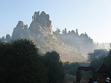
The Tustan rock complex in Skole Raion

Skole Beskids. View of the village Tukholka.
The terrain of Lviv Oblast is highly varied. The southern part is occupied by the low Beskyd (ukr: Бескиди) mountain chains running parallel to each other from northwest to southeast and covered with secondary coniferous forests as part of the Eastern Carpathians; the highest point is Pikuy (1408 m). North from there are the wide upper Dniester river valley and much smaller upper San River valley. These rivers have flat bottoms covered with alluvial deposits, and are susceptible to floods. Between these valleys and Beskyd lies the Precarpathian upland covered with deciduous forests, with well-known mineral spa resorts (see Truskavets, Morshyn). It's also the area of one of the earliest industrial petroleum and gas extraction. These deposits are all but depleted by now.
In the central part of the region lie Roztocze, Opillia, and part of the Podolia uplands. Rich sulphur deposits were mined here during the Soviet era. Roztocze is densely forested, while Opillia and Podolia (being covered with loess on which fertile soils develop) are densely populated and mostly covered by arable land. In the central-north part of the region lies the Small Polesia lowland, geographically isolated from the rest of Polesia but with similar terrain and landscapes (flat plains with sandy fluvioglacial deposits and pine forests). The far North of the region lies on the Volhynia upland, which is also covered with loess; coal is mined in this area.
Climate

Grassy flatlands with rolling hills in Drohobych Raion
The climate of Lviv Oblast is moderately cool and humid. The average January temperatures range from −7 °C (19 °F) in the Carpathians to −3 °C (27 °F) in the Dniester and San River valleys while in July the average temperatures are from 14–15 °C (57–59 °F) in the Carpathians to 16–17 °C (61–63 °F) in Roztocze and 19 °C (66 °F) in the lower part of the Dniester valley.[3] The average annual precipitation is 600–650 mm (23.62–25.59 in) in the lowlands, 650–750 mm (25.59–29.53 in) in the highlands and up to 1,000 mm (39.37 in) in the Carpathians, with the majority of precipitation occurring in summer. Prolonged droughts are uncommon, while strong rainfalls can cause floods in river valleys. Severe winds during storms can also cause damage, especially in the highlands. The climate is favourable for the cultivation of sugar beets, winter wheat, flax, rye, cabbage, apples, and for dairy farming. It is still too cold to successfully cultivate maize, sunflower, grapes, melon, watermelon or peaches in Lviv Oblast. In the Carpathians conditions are favourable for Alpine skiing 3–4 months a year.
Politics

Government House, Lviv
Raions of Lviv Oblast

Zashkiv village in Zhovkva district
Governors
- Chairmen of the Executive Committee
| Term start | Term end | Name | Year of birth | Year of death |
|---|---|---|---|---|
| March 1991 | 6 April 1992 | Vyacheslav Chornovil | b. 1937 | d. 1999 |
| June 1994 | July 1995 | Mykola Horyn | b. 1945 |
- Representative of the President
| Term start | Term end | Name | Year of birth |
|---|---|---|---|
| 20 March 1992 | June 1994 | Stepan Davymuka | b. 1947 |
- Heads of the Administration[4]
| Term start | Term end | Name | Year of birth | Year of death |
|---|---|---|---|---|
| 7 July 1995 | 6 Feb. 1997 | Mykola Horyn | b. 1945 | |
| 6 Feb. 1997 | 14 Jan. 1999 | Mykhailo Hladiy | b. 1952 | |
| 15 Jan. 1999 | 19 March 2001 | Stepan Senchuk | b. 1955 | d. 2005 |
| 26 March 2001 | 26 April 2002 | Mykhailo Hladiy | b. 1952 | |
| 26 April 2002 | 4 June 2003 | Myron Yankiv | b. 1951 | |
| 9 June 2003 | 20 Dec. 2004 | Oleksandr Sendeha | b. 1953 | |
| 20 Dec. 2004 | 4 Feb. 2005 | Bohdan Matolych (acting) | b. 1955 | |
| 4 Feb. 2005 | 20 Feb. 2008 | Petro Oliynyk | b. 1957 | |
| 20 Feb. 2008 | 27 Feb. 2008 | Valery Pyatak (acting) | b. 1959 | |
| 27 Feb. 2008 | 20 April 2010? | Kmit Mykola (acting to 1 Sep 2008) | b. 1966 | |
| 20 April 2010 | 21 December 2010[5] | Vasyl Horbal[6] | b. 1971 | |
| 21 December 2010 | 2 November 2011[5] | Mykhailo Tsymbaliuk[5] | b. 1964 | |
| 2 November 2011[5] | 4 March 2013[7] | Mykhailo Kostiuk[5] | b. 1961 | |
| 4 March 2013[7] | 31 October 2013[8] | Viktor Shemchuk[7] | b. 1970 | |
| 31 October 2013[8] | 23 January 2014[9] | Oleh Salo[8] | b. 1968 |
Subdivisions

Zhovkva. Temple of the Sacred Heart of Jesus

Church of Sts. Peter & Paul in Sokal

Church of Our Lady Protectress in Stryi
Lviv Oblast is administratively subdivided into 20 raions (districts), as well as 9 city (municipalities) which are directly subordinate to the oblast government: Boryslav, Chervonohrad, Drohobych, Morshyn, Novyi Rozdil, Sambir, Stryi, Truskavets, and the administrative center of the oblast, Lviv.
| In English | In Ukrainian | Administrative Center | |
|---|---|---|---|
Brody Raion | Бродівський район Brodivs'kyi raion | Brody (City) | |
Busk Raion | Буський район Bus'kyi raion | Busk (City) | |
Drohobych Raion | Дрогобицький район Drohobyts'kyi raion | Drohobych (City) | |
Horodok Raion | Городоцький район Horodots'kyi raion | Horodok (City) | |
Kamianka-Buzka Raion | Кам'янка-Бузький район Kamyanka-Buz'kyi raion | Kamianka-Buzka (City) | |
Mostyska Raion | Мостиський район Mostys'kyi raion | Mostyska (City) | |
Mykolaiv Raion | Миколаївський район Mykolayivs'kyi raion | Mykolaiv (City) | |
Peremyshliany Raion | Перемишлянський район Peremyshlians'kyi raion | Peremyshliany (City) | |
Pustomyty Raion | Пустомитівський район Pustomytivs'kyi raion | Pustomyty (City) | |
Radekhiv Raion | Радехівський район Radekhivs'kyi raion | Radekhiv (City) | |
Sambir Raion | Самбірський район Sambirs'kyi raion | Sambir (City) | |
Skole Raion | Сколівський район Skolivs'kyi raion | Skole (City) | |
Sokal Raion | Сокальський район Sokal's'kyi raion | Sokal (City) | |
Starosambirskyi Raion | Старосамбірський район Starosambirs'kyi raion | Staryi Sambir (City) | |
Stryiskyi Raion | Стрийський район Stryis'kyi raion | Stryi (City) | |
Turkivskyi Raion | Турківський район Turkivs'kyi raion | Turka (City) | |
Yavorivskyi Raion | Яворівський район Yavorivs'kyi raion | Yavoriv (City) | |
Zhovkivskyi Raion | Жовківський район Zhovkivs'kyi raion | Zhovkva (City) | |
Zhydachivskyi Raion | Жидачівський район Zhydachivs'kyi raion | Zhydachiv (City) | |
Zolochivskyi Raion | Золочівський район Zolochivs'kyi raion | Zolochiv (City) |
Demographics

Church of St.Anna in Boryslav, the fifth largest city in Lviv Oblast

Church of the Blessed Eucharist, Klymets, Skole district, Lviv region.
- Male/female ratio: 48%/52%
- Nationalities (2001): 94.8% of the region's population are Ukrainians; 3.6% (or 92,600 people) are Russians; Poles account for 0.7%; there are also smaller German, Jewish (0.2%), and Gypsy minorities.[10] Notably, the comparison of the 2001 Ukrainian census (mentioned above), with the last Soviet census of 1989 reveals that in those 12 years the number of Poles in the Lviv Oblast went down by 29.7 percent which, in the opinion of "Wspólnota Polska" Society defies explanation, and could possibly be attributed to the intensive Ukrainization of the Roman Catholic Church.[11]
Age structure
0-14 years: 15.7% (male 202,923/female 193,000)
15-64 years: 70.0% (male 867,699/female 897,788)
65 years and over: 14.3% (male 122,906/female 238,016) (2013 official)
Median age
total: 38.0 years
male: 35.2 years
female: 40.9 years (2013 official)
Religion
Fifty-nine percent of the religious organisations active in the Lviv Oblast adhere to the Ukrainian Greek Catholic Church. The Ukrainian Autocephalous Orthodox Church is the second largest religious body. The followers of the Roman Catholic Church and the Ukrainian Orthodox Church (Moscow Patriarchate) are mostly from the Polish, and Russian or non-Galician Ukrainian minorities respectively.
Historical and cultural sites
The city of Lviv contains a well-preserved main square (Rynok) and numerous historical and beautiful churches. Other sites of interest are the historic Lychakivskiy Cemetery, the local museum of folklore, and the ruins of the famous Vysokyi Zamok. The name of the castle is tightly tied with the name of the city. There is also a museum of military artifacts, the "Arsenal".
Well-preserved local wooden churches, castles, and monasteries can be found throughout the Oblast. One of them is the Olesko Castle which is first remembered in 1327. Another castle that was built at the end of the 15th century is Svirzh Castle in the village of Svirzh, Peremeshliany Raion. One more and no less famous castle is the Pidhirtsi Castle. Its architectural complex consists of the three-story palace, Kostel, and small park. In Roztochia is also located the Krekhivsky monastery in the buch-pine grove at the foot of the Pobiyna mount. The whole complex consists of the Saint Nikola Church, the bell tower, numerous service structures, and defensive walls with towers. Another site worth of mentioning is the Tustan city-fortress which is built in the rock. The site was nominated as the historical and as the natural wonder of Ukraine. There also a nature complex in the valley of the Kamianka river in Skoliv Raion. Another natural wonder of the region is the Kamin-Veleten (Rock-Giant in English) which is located near city of Pidkamin in Brodivskyi Raion. The name of the local city means Under the Rock. A local museum of Ukrainian art and an institution of higher learning (Ivan Franko State University) are also present.
Gallery

Wooden Trinity Church in Zhovkva

Zhovkva Castle

Villa in Drohobych

Svirzh Castle


Nomenclature
Most of Ukraine's oblasts are named after their capital cities, officially referred to as "oblast centers" (Ukrainian: обласний центр, translit. oblasnyi tsentr). The name of each oblast is a relative adjective, formed by adding a feminine suffix to the name of respective center city: L'viv is the center of the L'vivs'ka oblast' (Lviv Oblast). Most oblasts are also sometimes referred to in a feminine noun form, following the convention of traditional regional place names, ending with the suffix "-shchyna", as is the case with the Lviv Oblast, Lvivshchyna.
See also
List of Canadian place names of Ukrainian origin – Ukrainian immigrants to Canada brought place names from this oblast with them to Alberta, Manitoba, and Saskatchewan.
Poland’s Lwów Voivodeship (1921–1939)- Subdivisions of Ukraine
References
^ "Чисельність наявного населення України (Actual population of Ukraine)" (PDF) (in Ukrainian). State Statistics Service of Ukraine. Retrieved 19 July 2016..mw-parser-output cite.citation{font-style:inherit}.mw-parser-output .citation q{quotes:"""""""'""'"}.mw-parser-output .citation .cs1-lock-free a{background:url("//upload.wikimedia.org/wikipedia/commons/thumb/6/65/Lock-green.svg/9px-Lock-green.svg.png")no-repeat;background-position:right .1em center}.mw-parser-output .citation .cs1-lock-limited a,.mw-parser-output .citation .cs1-lock-registration a{background:url("//upload.wikimedia.org/wikipedia/commons/thumb/d/d6/Lock-gray-alt-2.svg/9px-Lock-gray-alt-2.svg.png")no-repeat;background-position:right .1em center}.mw-parser-output .citation .cs1-lock-subscription a{background:url("//upload.wikimedia.org/wikipedia/commons/thumb/a/aa/Lock-red-alt-2.svg/9px-Lock-red-alt-2.svg.png")no-repeat;background-position:right .1em center}.mw-parser-output .cs1-subscription,.mw-parser-output .cs1-registration{color:#555}.mw-parser-output .cs1-subscription span,.mw-parser-output .cs1-registration span{border-bottom:1px dotted;cursor:help}.mw-parser-output .cs1-ws-icon a{background:url("//upload.wikimedia.org/wikipedia/commons/thumb/4/4c/Wikisource-logo.svg/12px-Wikisource-logo.svg.png")no-repeat;background-position:right .1em center}.mw-parser-output code.cs1-code{color:inherit;background:inherit;border:inherit;padding:inherit}.mw-parser-output .cs1-hidden-error{display:none;font-size:100%}.mw-parser-output .cs1-visible-error{font-size:100%}.mw-parser-output .cs1-maint{display:none;color:#33aa33;margin-left:0.3em}.mw-parser-output .cs1-subscription,.mw-parser-output .cs1-registration,.mw-parser-output .cs1-format{font-size:95%}.mw-parser-output .cs1-kern-left,.mw-parser-output .cs1-kern-wl-left{padding-left:0.2em}.mw-parser-output .cs1-kern-right,.mw-parser-output .cs1-kern-wl-right{padding-right:0.2em}
^ Ukraine Facing Civil War: Lviv Declares Independence from Yanukovich Rule
^ WorldClimate.com (Data for L'viv)
^ Lviv, worldstatesmen.org
^ abcde Yanukovych appoints ex-Ukrzaliznytsia head Kostiuk governor of Lviv region, Kyiv Post (2 November 2011)
^ Horbal appointed Lviv regional governor, Kyiv Post (April 20, 2010)
^ abc Gryshchenko introduces new Lviv regional governor to local officials, Kyiv Post (4 March 2013)
^ abc Yanukovych appoints Salo as governor of Lviv region, UKRINFORM (23 January 2014)
^ Lviv governor Salo resigns – mass media, Unian (23 January 2013)
^ Державний комітет статистики України (2004). "Національний склад населення / Львівська область" [Ukrainian Census, Lviv Oblast]. Internet Archive. Archived from the original on September 26, 2010. Retrieved 10 December 2013.
^ Polonia w opracowaniach (2013). "Zmiany w liczebności ludności polskiej na Ukrainie w okresie 1989-2001" [Changes in the number of Poles in Ukraine in the period between 1989 and 2001]. Polacy na Ukrainie. Stowarzyszenie "Wspólnota Polska". Archived from the original on 2013-12-15. Retrieved 10 December 2013.
- Source for statistics used: L'viv Regional State Administration Web Site – accessed February 29, 2004.
External links
![]() Media related to Lviv Oblast at Wikimedia Commons
Media related to Lviv Oblast at Wikimedia Commons
- L'viv Regional State Administration Web Site
- Symbols and flags
Administrative center: Lviv | |||||
| Raions |
| ||||
| Cities |
| ||||
| |||||
Capital: Kiev | |
| Oblasts |
|
| Cities with special status |
|
| Autonomous republic |
|
| Administrative centers |
|
1Claimed and controlled by Russia as the Republic of Crimea and the Federal City of Sevastopol 2Regions are nearly controlled by Pro-Russian seperatists states of Donetsk People's Republic and Luhansk People's Republic | |
Coordinates: 49°43′03″N 23°57′01″E / 49.71750°N 23.95028°E / 49.71750; 23.95028
Authority control |
|
|---|


