Murray–Darling basin
| Murray-Darling | |
|---|---|
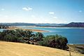
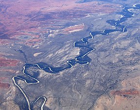 An aerial view of the Darling River near Menindee in the far west of the Basin, in New South Wales | |
 Map of the Murray–Darling basin | |
| Length | 3,375 km (2,097 mi) |
| Area | 1,061,469 km2 (409,835 sq mi) |
| Geography | |
| Country | Australia |
| States and territories | List
|
| Coordinates | 35°35′S 138°53′E / 35.583°S 138.883°E / -35.583; 138.883Coordinates: 35°35′S 138°53′E / 35.583°S 138.883°E / -35.583; 138.883 |
| Rivers | List
|
The Murray–Darling basin is a large geographical area in the interior of southeastern Australia. Its name is derived from its two major rivers, the Murray River and the Darling River. The basin, which drains around one-seventh of the Australian land mass,[1] is one of the most significant agricultural areas in Australia. It spans most of the states of New South Wales and Victoria, the Australian Capital Territory, and parts of the states of Queensland (lower third) and South Australia (southeastern corner). The basin is 3,375 kilometres (2,097 mi) in length, with the Murray River being 2,508 km (1,558 mi) long.
Most of the 1,061,469 km2 (409,835 sq mi) basin is flat, low-lying and far inland, and receives little direct rainfall. The many rivers it contains tend to be long and slow-flowing, and carry a volume of water that is large only by Australian standards.
Contents
1 The original inhabitants
2 Native fauna
2.1 2018–2019 fish kill
3 Introduced species
4 Physiography
4.1 Rivers in the Murray–Darling basin
5 Management
5.1 The Murray–Darling Basin plan
5.1.1 History
5.1.2 Sustainability and risks
6 See also
7 References
8 External links
The original inhabitants
The basin was once home to a large number of Aboriginal people whose traditional lifestyle and cultures were gradually destroyed by the arrival of Europeans. In addition, some were killed by English settlers. Although some tribes organized resistance, such as the Maraura, whose territory lay around the Rufus River above Renmark and the Tanganekald near The Coorong, they were eventually either killed, exiled, or succumbed to disease.[2]
Native fauna
The Murray–Darling basin is home to many native animal species. The true numbers may not be known, but a fairly confident estimate has been made of these animals and the current status of their population. Among the aboriginal fauna in the region, the study found[citation needed] that there were:
- 80 species of mammals, with 62 extinct and 10 endangered
- 55 species of frogs, with 18 endangered
- 46 species of snakes, with five endangered
- 5 species of tortoises, with none endangered
- 34 species of fish, with up to half either threatened or of conservation significance[3]
Historical records show that the previous abundances of fish provided a reliable food source.[4] The bountiful fish became concentrated when the early stages of a flood left shallow water across the floodplain.[4] Today, roughly 24 native freshwater fish and another 15-25 marine and estuarine species are existent in the basin, a very low biodiversity.[4]
2018–2019 fish kill
Over Christmas 2018 and January 2019 there were two mass deaths of fish in the waters of the basin, the first numbering 10,000, the second in the 100,000s.[5] Species affected were Murray cod, golden perch, silver perch and bony herring.[5] Some blamed the draining of water from the Menindee Lakes by WaterNSW, with only 2.5% of the original water volume in the lakes being left; after the first fish kill, both the Department of Primary Industries (DPI) and WaterNSW blamed the ongoing drought affecting Australia, while the DPI blamed the second kill on a disruption of an algal bloom caused by falling temperature.[5]
Introduced species
Four varieties of carp were used to stock up fish dams. Since then they have made their way into the river systems, where they spread quite quickly. Human introduction, possibly by anglers using small carp illegally as live bait has also increased their distribution.[6] These fish are very mobile, breed rapidly and can survive in very shallow water and through long periods of very low dissolved oxygen content.
Carp are a problem because they feed by sucking gravel from the riverbed and taking all the edible material off it, before returning the rest to the water. This stirs up all the sediment, reducing the quality of the water. A project for developing daughterless carp shows promise for eliminating carp from the river system.
Cane toads have entered the upper reaches of the Darling Basin and there are several reports of individuals being found further down the system.[7] Cane toads compete with native amphibians and are toxic to native carnivores.
Physiography
This area is one of the physiographic provinces of the larger East Australian basins division, and encompasses the smaller Naracoorte Platform and Encounter Shelf physiographic sections.
Total water flow in the Murray–Darling basin 1885 to the present has averaged around 24,000 gigalitres (24,000 hm3; 19,000,000 acre⋅ft) per year. This is the lowest rate of the world's major river systems.[1] About 6.0 percent of Australia's total rainwater falls into the basin.[8] In most years only half of this quantity reaches the sea and in dry years much less. Estimated total annual flows for the basin have ranged from 5,000 gigalitres (5,000 hm3; 4,100,000 acre⋅ft) in 1902 to 57,000 gigalitres (57,000 hm3; 46,000,000 acre⋅ft) in 1956[citation needed]. Despite the magnitude of the basin, the hydrology of the streams within it is quite varied.
These waters are divided into four types:[9]
- The Darling and Lachlan basins. These have extremely variable flows from year to year, with the smallest annual flow being typically as little as 1 percent of the long-term mean and the largest often more than ten times the mean. Periods of zero flow in most rivers can extend to months and in the drier parts (Warrego, Paroo and Lower Darling basins) to years.[9] Flows in these rivers are not strongly seasonal. In the northern regions the majority of floods occur in the summer from monsoonal penetration. For most of the Darling and Lachlan catchments it is typical to see high or low flows begin in winter and extend to the following autumn (see El Niño). High water extraction rates for irrigation and mining have heavily compromised these rivers.
- The southwestern basins (Campaspe, Loddon, Avoca, Wimmera). These have a marked winter rainfall maximum and relatively lower precipitation variability than the Lachlan or Darling. However, the age and infertility of the soils mean that run-off ratios are exceedingly low (for comparison, around a tenth that of a European or North American catchment with a similar climate[10]). Thus, variability of runoff is very high and most of the terminal lakes found in these basins very frequently dry up. Almost all runoff occurs in the winter and spring and, in the absence of large dams for regulation, these rivers are often seasonally dry during summer and autumn.
- A number of small catchments in South Australia, of which the largest are the Angas River flowing through Strathalbyn and the Finniss River further west, are part of the Murray–Darling Basin. These catchments lead to Lake Alexandrina, one of the lakes at the end of the Murray system. The Angas River is often dry in summer because of high levels of water extraction. The Finniss River has permanent flow into Lake Alexandrina but was cut off by a weir for several years of dorught in the early 21st century.
- The Murray, Murrumbidgee and Goulburn (except the Broken River which resembles the southwestern basins) Basins. Because these catchments have headwaters in alpine country with relatively young peaty soils, the runoff ratios are much higher than in other parts of the basin. Consequently, although gross precipitation variability is no lower than in the Lachlan or Darling basins, runoff variability is markedly lower than in other parts of the basin. Typically these rivers never cease to flow and the smallest annual flow is typically around 30 percent of the long-term mean and the largest around three times the mean. In most cases the flow peaks very strongly with the spring snow melt and troughs in mid-autumn.
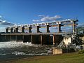
The two principal rivers of the basin, the Murray and Darling, bring water from the high ranges of the east and carry it west then south through long flat and dry inland areas.[11] Nevertheless, these waters are subject to major diversions for municipal drinking supplies and irrigated agriculture that began in the 1890s.[4] Currently, 4 major reservoirs, 14 lock and weir structures, and five coastal barrages interject the water flowing down the Murray-Darling.[4] Of the approximately 13,000 gigalitres (13,000 hm3; 10,500,000 acre⋅ft) of flow in the basin, which studies have shown to be divertible, 11,500 gigalitres (11,500 hm3; 9,320,000 acre⋅ft) are removed for irrigation, industrial use, and domestic supply. Agricultural irrigation accounts for about 95 percent of the water removed,[1] including for the growing of rice and cotton. This extraction is highly controversial among scientists in Australia, regarding the agriculture industry's high water use in a region extremely short of water (as much due to exceptionally low run-off coefficients as to low rainfall).[12] These extensive irrigation systems require a reliable supply of water, not the unpredictable flows that characterize the Murray-Darling.[4] These structures and irrigation implements were ideal when there was a steady flow of water.[13] However, during “the Big Dry,” as the early 2000s drought came to be known, Australian farmers experienced a scarcity unlike ever before. The drought was so severe that numerous rivers and streams such as the Murray-Darling stopped flowing.[13] The basin contains more than 30,000 wetlands.[14] Eleven of these are protected under the Ramsar Convention of Wetlands of International Importance.
Rivers in the Murray–Darling basin
Yarrawonga Weir on the Murray River forms Lake Mulwala, 2010
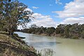
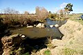
Darling River at Menindee, 2009

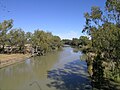
Warrego River at Cunnamulla, 2010
Barwon River at Collarenebri, 2008
Lake Burrendong, formed at the confluence of the Macquarie River and Cudgegong River, 1995
Macquarie River at Bathurst, 2009

Siphon irrigation of cotton on the Balonne River near St George, 2012

Maranoa River at Mitchell, 2005
Macintyre River in flood at Goondiwindi, 1921

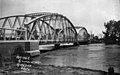
Taemas Bridge across the Murrumbidgee River, 2011

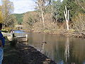
Goodradigbee River in the valley below the Brindabella Ranges, 2005

Molonglo River at Acton in 1920, prior to the damming of the river to form Lake Burley Griffin.

Wakool River, near Kyalite, 2012

A footbridge of the Avoca River at Charlton, 2005

Goulburn River at Murchison, 2009
Ovens River at Porepunkah, 2007

Mitta Mitta River, downstream from Dartmouth Dam, 2007


The rivers listed below comprise the Murray–Darling basin and its direct significant tributaries, with elevations of their confluence with the downstream river. The tributary with the highest elevation is Swampy Plain River that rises in the Snowy Mountains, below Mount Kosciuszko at an elevation of 2,120 metres (6,960 ft), and ends merging with the Murray River, descending 1,860 metres (6,100 ft).
The ordering of the basin, from downstream to upstream, is:
| Rivers of the Murray–Darling basin | ||||||||||||
|---|---|---|---|---|---|---|---|---|---|---|---|---|
| Catchment river | Elevation at confluence | River mouth | States | River length | ||||||||
| Tributary | ||||||||||||
| Tributary | ||||||||||||
| Tributary | ||||||||||||
| Tributary | ||||||||||||
| Tributary | ||||||||||||
| Tributary | m | ft | km | mi | ||||||||
Murray River | 0 | 0 | Southern Ocean | NSW, Vic, SA | 2,375 | 1,476 | ||||||
Darling River | 35 | 115 | Murray | NSW | 1,472 | 915 | ||||||
Paroo River | 94 | 308 | Darling | Qld, NSW | 1,210 | 750 | ||||||
Warrego River | 98 | 322 | Darling | Qld, NSW | 1,380 | 860 | ||||||
Langlo River | 280 | 920 | Warrego | Qld | 440 | 270 | ||||||
Nive River | 336 | 1,102 | Warrego | Qld | 263 | 163 | ||||||
Culgoa River | 109 | 358 | Darling | Qld, NSW | 489 | 304 | ||||||
Birrie River | 115 | 377 | Culgoa | Qld | 197 | 122 | ||||||
Barwon River (New South Wales) | 110 | 360 | Darling | NSW | 700 | 430 | ||||||
Bokhara River | 113 | 371 | Barwon | Qld, NSW | 347 | 216 | ||||||
Namoi River | 130 | 430 | Barwon | NSW | 708 | 440 | ||||||
Mooki River | 264 | 866 | Namoi | NSW | 128 | 80 | ||||||
Peel River (New South Wales) | 286 | 938 | Namoi | NSW | 210 | 130 | ||||||
Cockburn River | 384 | 1,260 | Peel | NSW | 34 | 21 | ||||||
Manilla River | 349 | 1,145 | Namoi | NSW | 138 | 86 | ||||||
Macdonald River (Bendemeer) | 705 | 2,313 | Namoi | NSW | 169 | 105 | ||||||
Cobrabald River | 990 | 3,250 | Macdonald | NSW | 53 | 33 | ||||||
Gwydir River | 144 | 472 | Barwon | NSW | 488 | 303 | ||||||
Horton River | 270 | 890 | Gwydir | NSW | 128 | 80 | ||||||
Moredun Creek | 645 | 2,116 | Gwydir | NSW | 210 | 130 | ||||||
Rocky River (New South Wales) | 760 | 2,490 | Gwydir | NSW | 138 | 86 | ||||||
Mehi River | 145 | 476 | Barwon | NSW | 314 | 195 | ||||||
Moonie River | 149 | 489 | Barwon | NSW | 542 | 337 | ||||||
Boomi River | 152 | 499 | Barwon | NSW, Qld | 231 | 144 | ||||||
Macquarie River | 154 | 505 | Barwon | NSW | 960 | 600 | ||||||
Castlereagh River | 121 | 397 | Macquarie | NSW | 541 | 336 | ||||||
Talbragar River | 258 | 846 | Macquarie | NSW | 277 | 172 | ||||||
Coolaburragundy River | 271 | 889 | Talbragar | NSW | 156 | 97 | ||||||
Little River (Dubbo) | 271 | 889 | Macquarie | NSW | 122 | 76 | ||||||
Bell River (New South Wales) | 285 | 935 | Macquarie | NSW | 146 | 91 | ||||||
Cudgegong River | 342 | 1,122 | Macquarie | NSW | 250 | 160 | ||||||
Turon River | 406 | 1,332 | Macquarie | NSW | 117 | 73 | ||||||
Crudine River | 563 | 1,847 | Turon | NSW | 54 | 34 | ||||||
Fish River (New South Wales) | 668 | 2,192 | Macquarie | NSW | 119 | 74 | ||||||
Campbells River | 706 | 2,316 | Fish | NSW | 82 | 51 | ||||||
Duckmaloi River | 1,010 | 3,310 | Fish | NSW | 27 | 17 | ||||||
Weir River (Queensland) | 166 | 545 | Barwon | Qld, NSW | 197 | 122 | ||||||
Balonne River | 171 | 561 | Barwon | Qld | 479 | 298 | ||||||
Maranoa River | 207 | 679 | Balonne | Qld | 519 | 322 | ||||||
Merivale River | 401 | 1,316 | Maranoa | Qld | 205 | 127 | ||||||
Condamine River | 256 | 840 | Balonne | Qld | 657 | 408 | ||||||
Macintyre River | 224 | 735 | Barwon | NSW, Qld | 319 | 198 | ||||||
Dumaresq River | 227 | 745 | Macintyre | NSW | 214 | 133 | ||||||
Macintyre Brook | 241 | 791 | Dumaresq | Qld | 165 | 103 | ||||||
Beardy River | 354 | 1,161 | Dumaresq | NSW | 90 | 56 | ||||||
Pike Creek (Queensland) | 360 | 1,180 | Dumaresq | Qld | 117 | 73 | ||||||
Mole River (New South Wales) | 363 | 1,191 | Dumaresq | Qld | 73 | 45 | ||||||
Deepwater River | 601 | 1,972 | Mole | NSW | 84 | 52 | ||||||
Bluff River (New South Wales) | 614 | 2,014 | Mole | NSW | 13 | 8.1 | ||||||
Severn River (Queensland) | 375 | 1,230 | Dumaresq | Qld, NSW | 90 | 56 | ||||||
Severn River (New South Wales) | 284 | 932 | Macintyre | NSW | 52 | 32 | ||||||
Beardy Waters | 884 | 2,900 | Severn (NSW) | NSW | 70 | 43 | ||||||
Bogan River | 111 | 364 | Darling | NSW | 617 | 383 | ||||||
Little River (Parkes) | 305 | 1,001 | Bogan | NSW | 319 | 198 | ||||||
Murrumbidgee River | 55 | 180 | Murray | NSW, ACT | 1,488 | 925 | ||||||
Lachlan River | 68 | 223 | Murrumbidgee | NSW | 1,440 | 890 | ||||||
Belubula River | 262 | 860 | Lachlan | NSW | 165 | 103 | ||||||
Boorowa River | 301 | 988 | Lachlan | NSW | 134 | 83 | ||||||
Abercrombie River | 375 | 1,230 | Lachlan | NSW | 130 | 81 | ||||||
Isabella River (New South Wales) | 479 | 1,572 | Abercrombie | NSW | 51 | 32 | ||||||
Bolong River | 589 | 1,932 | Abercrombie | NSW | 60 | 37 | ||||||
Tumut River | 220 | 720 | Murrumbidgee | NSW | 182 | 113 | ||||||
Goobarragandra River | 272 | 892 | Tumut | NSW | 56 | 35 | ||||||
Doubtful Creek | 1,290 | 4,230 | Tumut | NSW | 15 | 9.3 | ||||||
Yass River | 345 | 1,132 | Murrumbidgee | NSW | 139 | 86 | ||||||
Goodradigbee River | 345 | 1,132 | Murrumbidgee | NSW | 105 | 65 | ||||||
Crookwell River | 430 | 1,410 | Murrumbidgee | NSW | 78 | 48 | ||||||
Molonglo River | 440 | 1,440 | Murrumbidgee | NSW, ACT | 115 | 71 | ||||||
Jerrabomberra Creek | 554 | 1,818 | Molonglo | NSW, ACT | 35 | 22 | ||||||
Sullivans Creek | 556 | 1,824 | Molonglo | NSW, ACT | 13 | 8.1 | ||||||
Queanbeyan River | 567 | 1,860 | Molonglo | NSW, ACT | 104 | 65 | ||||||
Cotter River | 460 | 1,510 | Murrumbidgee | ACT | 74 | 46 | ||||||
Paddys River (Australian Capital Territory) | 477 | 1,565 | Cotter | ACT | 28 | 17 | ||||||
Tidbinbilla River | 618 | 2,028 | Paddys | ACT | 13 | 8.1 | ||||||
Gibraltar Creek | 647 | 2,123 | Paddys | ACT | 13 | 8.1 | ||||||
Gudgenby River | 573 | 1,880 | Murrumbidgee | ACT | 35 | 22 | ||||||
Naas River | 631 | 2,070 | Gudgenby | ACT | 26 | 16 | ||||||
Orroral River | 842 | 2,762 | Gudgenby | ACT | 15 | 9.3 | ||||||
Bredbo River | 695 | 2,280 | Murrumbidgee | NSW | 52 | 32 | ||||||
Strike-a-Light River | 733 | 2,405 | Bredbo | NSW | 38 | 24 | ||||||
Numeralla River | 706 | 2,316 | Murrumbidgee | NSW | 94 | 58 | ||||||
Big Badja River | 735 | 2,411 | Numeralla | NSW | 32 | 20 | ||||||
Kybeyan River | 745 | 2,444 | Numeralla | NSW | 36 | 22 | ||||||
Wakool River | 58 | 190 | Murray | NSW | 363 | 226 | ||||||
Niemur River | 63 | 207 | Wakool | NSW | 155 | 96 | ||||||
Edward River (an anabranch) | 61 | 200 | Murray | NSW | 383 | 238 | ||||||
Little Murray River (Victoria) | 67 | 220 | Murray | Vic | 46 | 29 | ||||||
Loddon River | 71 | 233 | Murray | Vic | 392 | 244 | ||||||
Avoca River | 74 | 243 | Murray | Vic | 270 | 170 | ||||||
Little Murray River (New South Wales) | 75 | 246 | Murray | NSW | 22 | 14 | ||||||
Goulburn River, Victoria | 100 | 330 | Murray | Vic | 654 | 406 | ||||||
Broken River (Victoria) | 118 | 387 | Goulburn | Vic | 225 | 140 | ||||||
Yea River | 162 | 531 | Goulburn | Vic | 122 | 76 | ||||||
Murrindindi River | 186 | 610 | Yea | Vic | 26 | 16 | ||||||
Acheron River | 190 | 620 | Goulburn | Vic | 84 | 52 | ||||||
Little River (Cathedral Range) | 207 | 679 | Acheron | Vic | 22 | 14 | ||||||
Steavenson River | 264 | 866 | Acheron | Vic | 20 | 12 | ||||||
Taggerty River | 368 | 1,207 | Steavenson | Vic | 18 | 11 | ||||||
Rubicon River | 200 | 660 | Goulburn | Vic | 43 | 27 | ||||||
Royston River | 381 | 1,250 | Rubicon | Vic | 19 | 12 | ||||||
Big River (Goulburn River, Victoria) | 259 | 850 | Goulburn | Vic | 62 | 39 | ||||||
Delatite River | 260 | 850 | Goulburn | Vic | 83 | 52 | ||||||
Howqua River | 265 | 869 | Goulburn | Vic | 66 | 41 | ||||||
Jamieson River | 294 | 965 | Goulburn | Vic | 33 | 21 | ||||||
Campaspe River | 123 | 404 | Murray | Vic | 232 | 144 | ||||||
Coliban River | 183 | 600 | Campaspe | Vic | 89 | 55 | ||||||
Little Coliban River | 501 | 1,644 | Coliban | Vic | 12 | 7.5 | ||||||
Ovens River | 125 | 410 | Murray | Vic | 191 | 119 | ||||||
King River, Victoria | 142 | 466 | Ovens | Vic | 126 | 78 | ||||||
Buffalo River (Australia) | 206 | 676 | Ovens | Vic | 65 | 40 | ||||||
Dandongadale River | 279 | 915 | Buffalo | Vic | 41 | 25 | ||||||
Catherine River (Victoria) | 392 | 1,286 | Buffalo | Vic | 25 | 16 | ||||||
Buckland River (Victoria) | 274 | 899 | Ovens | Vic | 38 | 24 | ||||||
Kiewa River | 156 | 512 | Murray | Vic, NSW | 109 | 68 | ||||||
Mitta Mitta River | 180 | 590 | Murray | Vic | 204 | 127 | ||||||
Dart River (Victoria) | 452 | 1,483 | Mitta Mitta | Vic | 29 | 18 | ||||||
Big River (Mitta Mitta River, Victoria) | 655 | 2,149 | Mitta Mitta | Vic | 52 | 32 | ||||||
Cobungra River | 656 | 2,152 | Mitta Mitta | Vic | 55 | 34 | ||||||
Victoria River (Victoria) | 830 | 2,720 | Cobungra | Vic | 25 | 16 | ||||||
Tooma River | 238 | 781 | Murray | NSW | 74 | 46 | ||||||
Swampy Plain River | 269 | 883 | Murray | NSW, Vic | 59 | 37 | ||||||
Geehi River | 439 | 1,440 | Swampy Plain | Vic | 47 | 29 | ||||||
Management
The basin covers five states and territory governments, who according to the Constitution, are responsible for managing water resources. The River Murray Commission was established in 1917.[1] Under the River Murray Waters Agreement, which never included Queensland despite the state containing about a quarter of the basin, the Commission's role was only as an advisory body with no authority for the enforcement of provisions. For a long time the Commission was only concerned with water quantity until salinity became a problem.[15] This led to minor reforms in 1982 in which water quality became part of the Commission's responsibilities.[1] However, it was soon recognised that a new organisational structure which considered the national perspective was needed for effective management.
The Murray–Darling Basin Agreement was first adopted in 1985 but it wasn't until 1993 that its full legal status was enacted.[1] The Agreement led to the creation of a number of new organisations under what is known as the Murray-Darling Basin Initiative. These included the Murray-Darling Basin Ministerial Council and the Murray Darling Basin Commission.
The Murray–Darling Basin plan
The Murray-Darling Basin Plan was signed off by Tony Burke, Minister for Sustainability, Environment, Water, Population and Communities on 22 November 2012, and passed disallowance period in the Australian Parliament on the 19 March 2013. Following is the history leading up to this significant occasion in the history of Australian water reform.
History
In October 2010, in response to the 2000s Australian drought, the Murray–Darling Basin Authority released a draft plan to secure the long-term ecological health of the Murray–Darling Basin. This entailed cutting existing water allocations and increasing environmental flows.[16] The document is officially titled the Guide to the Proposed Murray–Darling Basin Plan. It is the first part of a three-stage process to address the problems of the Murray–Darling Basin.[17] MDBA is responsible for preparing and overseeing a legally-enforceable management plan — the Basin Plan.
The Basin Plan is designed to set environmentally sustainable limits on the quantities of water that may be taken from Basin water resources, to set Basin-wide environmental, water quality and salinity objectives, to develop efficient water trading regimes across the Basin, to set requirements for state water resource plans and to improve water security for all Basin users.[18] It also intends to minimise social and economic impacts whilst achieving the plan's environmental outcomes.[19]
With the release of the Guide to the Proposed Murray–Darling Basin Plan there have been a number of protests and voiced concerns about the plan in rural towns that the MDBA visited to present the plan to consultation meetings.[20] More than 5,000 people attended a MDBA meeting in Griffith where Griffith Mayor, Mike Neville, said the plan would "obliterate" Murrumbidgee valley communities.[21] Other groups also echo this feeling, such as the Victorian Farmers Federation[22] and Wine Group Growers' Australia.[23] Conversely, support for the Murray–Darling Basin plan has been received by various groups, including Australian Conservation Foundation,[24] and Environment Victoria.[25]
New legal advice from the lawyers of the Federal Government is changing the plan. The Government's interpretation is that the plan must give equal weight to the environmental, social, and economic impacts of proposed cuts to irrigation.
Environmentalists and South Australian irrigators, at the end of the river in South Australia, say that the authority should stick to its original figure.[26]
In October 2010, a parliamentary inquiry into the economic impacts of the plan was announced.[27]
In late October 2010 the Water Minister, Tony Burke, played down the prospect of a High Court challenge to the Murray–Darling Basin plan, as confusion continued over new legal advice released by the Government. In response to community concerns that the Murray–Darling Basin Authority had put environmental issues first over social and economic needs, Burke released new advice on the requirements of the Water Act. Burke stated that the Act does allow for the authority to "optimise" the needs of all three areas, but constitutional lawyer, George Williams, had cast doubts over the interpretation of the laws, stating it could be subject to a legal challenge.[28]
The MDBA announced in November 2010 that it might be forced to push back the release of its final plan for the river system until early 2012.[29]
The then MDBA chairman, Mike Taylor, reassured the public meeting that more work is being done to look at how the proposed cuts would affect regional communities. He stated; "Importantly, we want to make sure the social and economic impacts—which under any sort of scenario is very significant—were fully teased out".[30] Taylor resigned as he allegedly believed that the overriding principle should be the environmental outcome which was in conflict with the Gillard Government and following a period of sustained criticism of the Authority and the implementation of the proposed draft basin plan.[31] He was replaced by former New South Wales Planning Minister, Craig Knowles.[32][33][34]
In late May 2012, the revised plan was forwarded to state water ministers.[35] It did not alter the recommendation to cut 2,750 gigalitres (2.75 km3; 2,230,000 acre⋅ft) of water entitlements.
Following much negotiation between the Commonwealth and State governments and numerous submissions from interested stakeholders and the community, the Basin Plan became law in November 2012 and can now be implemented.
Sustainability and risks
Although the Murray-Darling Basin Plan (MDBP) is a positive step[according to whom?] towards sustainability the measures keep a significant risk of human activities exacerbating the drought risk (see River Murray which has only dried up twice since records began[citation needed]). The Environmental Water Requirement found that a reduction in allocations of 7,600 GL (7.60 km3; 6,160,000 acre⋅ft) (per year) is required to be certain that the river systems would maintain their health[citation needed]. However objectors[Like whom?] cite socio-economic impacts of major cutbacks to the widescale farming (and in some areas wine-growing) in the basin, and conclude that within plans for population growth, particularly in times of drought, may be a need for sustainable water transportation from new extraction from rivers in the wettest part of the country, the Cape York Peninsula or more desalination.
See also
- Climate change in Australia
- Drought in Australia
- Murray–Darling Cap
- Western Plateau
- List of Darling River distances
- List of Murray River crossings
- List of Murray River distances
- List of Murrumbidgee River distances
References
^ abcdef Pigram, John J. (2007). Australia's Water Resources: From use to management. Collingwood, Victoria: CSIRO Publishing. pp. 160–162. ISBN 978-0-643-09442-0..mw-parser-output cite.citation{font-style:inherit}.mw-parser-output .citation q{quotes:"""""""'""'"}.mw-parser-output .citation .cs1-lock-free a{background:url("//upload.wikimedia.org/wikipedia/commons/thumb/6/65/Lock-green.svg/9px-Lock-green.svg.png")no-repeat;background-position:right .1em center}.mw-parser-output .citation .cs1-lock-limited a,.mw-parser-output .citation .cs1-lock-registration a{background:url("//upload.wikimedia.org/wikipedia/commons/thumb/d/d6/Lock-gray-alt-2.svg/9px-Lock-gray-alt-2.svg.png")no-repeat;background-position:right .1em center}.mw-parser-output .citation .cs1-lock-subscription a{background:url("//upload.wikimedia.org/wikipedia/commons/thumb/a/aa/Lock-red-alt-2.svg/9px-Lock-red-alt-2.svg.png")no-repeat;background-position:right .1em center}.mw-parser-output .cs1-subscription,.mw-parser-output .cs1-registration{color:#555}.mw-parser-output .cs1-subscription span,.mw-parser-output .cs1-registration span{border-bottom:1px dotted;cursor:help}.mw-parser-output .cs1-ws-icon a{background:url("//upload.wikimedia.org/wikipedia/commons/thumb/4/4c/Wikisource-logo.svg/12px-Wikisource-logo.svg.png")no-repeat;background-position:right .1em center}.mw-parser-output code.cs1-code{color:inherit;background:inherit;border:inherit;padding:inherit}.mw-parser-output .cs1-hidden-error{display:none;font-size:100%}.mw-parser-output .cs1-visible-error{font-size:100%}.mw-parser-output .cs1-maint{display:none;color:#33aa33;margin-left:0.3em}.mw-parser-output .cs1-subscription,.mw-parser-output .cs1-registration,.mw-parser-output .cs1-format{font-size:95%}.mw-parser-output .cs1-kern-left,.mw-parser-output .cs1-kern-wl-left{padding-left:0.2em}.mw-parser-output .cs1-kern-right,.mw-parser-output .cs1-kern-wl-right{padding-right:0.2em}
^ H. A. Lindsay (1975). "Ch. 11: Aborigines in the Murray Valley". In G. V. Lawrence and Graeme Kinross Smith. The Book of the Murray. Rigby Ltd. ISBN 0 85179 917 5.
^ "Proposed Murray Darling Basin Plan" (PDF). Murray-Darling Basin Authority. August 2012. Archived from the original (PDF) on 13 November 2012. Retrieved 7 October 2012.
^ abcdef Wohl, Ellen E. (2010), A World of Rivers: Environmental Change on Ten of the World's Great Rivers, Chicago: University of Chicago Press
^ abc Davies, Anne (7 January 2019). "Hundreds of thousands of native fish dead in second Murray-Darling incident". The Guardian. Retrieved 17 January 2019.
^ "General information about carp - biology, ecology and impacts". New South Wales Department of Primary Industires. Retrieved 10 February 2012.
^ Ayers, D., Mazzer, T.M. and Ellis, M.V. (2004). Herpetofauna of the Darling Basin. In: The Darling (Eds. R. Breckwoldt, R. Boden and J. Andrew) (Murray-Darling Basin Commission, Canberra).
^ Prideaux, Bruce (2009). "River Heritage: the Murray–Darling River". In Prideaux, Bruce; Cooper, Malcolm. River Tourism. Wallingford, United Kingdom: CAB International. p. 167. ISBN 978-1-84593-468-2. Retrieved 18 December 2011.
^ ab Brown, J. A. H. (John Alexander Henstridge); Australia's Surface Water Resources.
ISBN 0-644-02617-0
^ McMahon, T.A. and Finlayson, B.L.; Global Runoff: Continental Comparisons of Annual Flows and Peak Discharges; pp. 86–98
ISBN 3-923381-27-1.
^ Weir, Jessica K. 2009. Murray River country: an ecological dialogue with traditional owners. Canberra: Aboriginal Studies Press.
^ Government, politics, power and policy in Australia / [editors] Dennis Woodward, Andrew Parkin, John Summers.
^ ab Richter, Brian D. (2014), Chasing water: a guide for moving from scarcity to sustainability
^ Connell, Daniel (January 2015). "Irrigation, water markets and sustainability in Australia's Murray-Darling Basin". Agriculture and Agricultural Science Procedia. 4: 133–139. doi:10.1016/j.aaspro.2015.03.016. Retrieved 10 October 2015.
^ "Murray- Darling river: Water quality management". 2015-09-29. Retrieved 23 August 2016.
^ Joseph Thomsen (12 October 2010). "MDBA Chair explains water allocation cuts". ABC Goulburn Murray. Australian Broadcasting Corporation. Retrieved 17 October 2010.
^ Clarke, Sarah (8 October 2010). "The Murray-Darling plan explained". ABC News. Australian Broadcasting Corporation. Archived from the original on 17 April 2011.
^ Murray-Darling Basin Authority, Summary of Murrumbidgee Region From the Guide to the proposed Basin Plan (PDF), Australian Government, archived from the original (PDF) on 10 April 2013
^ Arup, Tom (31 May 2010). "Joyce signals fight over plan for Murray–Darling Basin". The Sydney Morning Herald. Fairfax Media. Archived from the original on 7 November 2012.
^ "Tractor convoy as SA irrigators protest". ABC News. Australian Broadcasting Corporation. 15 October 2010. Archived from the original on 31 October 2010.
^ "Griffith irrigators vent anger". Weekly Times. 20 October 2010. Retrieved 21 October 2010.
^ VFF Declares War!: Stop the MDBA plundering Archived 17 September 2012 at Archive.today.
^ Federal Government urged "not to forget people" in Basin Plan Archived 6 July 2011 at the Wayback Machine. Media Release. 13 October 2010.
^ Cautious support from scientists for the emerging Murray‐Darling Basin Plan[permanent dead link].
^ Murray-Darling Basin Plan – what's it all about?, Environment Victoria, 11 March 2010, archived from the original on 31 October 2012
^ Om, Jason (27 October 2010). "SA irrigators back Murray–Darling cuts". ABC News. Australian Broadcasting Corporation. Archived from the original on 12 November 2012.
^ Lee, Tim (18 October 2010). "Murray authority chairman faces uphill battle". ABC News. Archived from the original on 22 December 2010.
^ Rodgers, Emma (28 October 2010). "Burke plays down challenge to basin plan". ABC News. Australian Broadcasting Corporation. Archived from the original on 30 October 2010.
^ Binnie, Kerrin (2 November 2010). "Basin authority flags delay to final plan". ABC News. Australian Broadcasting Corporation. Archived from the original on 4 November 2010.
^ "Water cuts treat farmers as 'second-class citizens". ABC News. Australian Broadcasting Corporation. 4 November 2010. Archived from the original on 4 November 2010.
^ Rodgers, Emma (7 December 2010). "Murray–Darling boss resigns". ABC News. Australian Broadcasting Corporation. Archived from the original on 12 November 2012.
^ Coorey, Phillip (28 January 2011). "Ex-NSW minister Craig Knowles to be Murray Darling supremo". The Sydney Morning Herald. Fairfax Media. Archived from the original on 29 October 2016.
^ Coorey, Phillip (29 January 2011). "A cosy number for a party mate or the right man for the job?". The Sydney Morning Herald. Fairfax Media. Archived from the original on 7 November 2012. Retrieved 29 January 2011.
^ Kruger, Paula (28 January 2011). "'Jobs for mate' claims dog new Murray–Darling chief". ABC News. Australian Broadcasting Corporation. Archived from the original on 5 March 2011.
^ Anna Vidot and rural reporters (28 May 2012). "Murray-Darling plan delivered to states". ABC Rural. Australian Broadcasting Corporation. Archived from the original on 29 May 2012. Retrieved 29 May 2012.
External links
- Murray-Darling Basin Authority
- Murray-Darling Basin Water Budget Project
- Murray Darling Freshwater Research Centre
- River Murray Water Restrictions
- Murray Outback - Guide to the major towns on the Murray and Murray Outback Region.
Save the Murray - lobby group- Murray Darling Basin Resources
- The Basin Plan
- Guide to the Proposed Basin Plan
- Guide to the Basin Plan, Volumes 1 - 21
Basin Plan - lobby group
- News
"Fire, Flood and Acid Mud", Catalyst, Australian Broadcasting Corporation, archived from the original on 19 April 2016
Rivers of the Murray–Darling basin, Australia | |||||||||||||||
|---|---|---|---|---|---|---|---|---|---|---|---|---|---|---|---|
| |||||||||||||||
| |||||||||||||||
| |||||||||||||||
| |||||||||||||||
Drainage basins of Australia | |
|---|---|
| |
|


