Dietikon
Dietikon | ||
|---|---|---|
 | ||
| ||
Location of Dietikon | ||
 Dietikon Show map of Switzerland  Dietikon Show map of Canton of Zurich | ||
| Coordinates: 47°24′N 8°24′E / 47.400°N 8.400°E / 47.400; 8.400Coordinates: 47°24′N 8°24′E / 47.400°N 8.400°E / 47.400; 8.400 | ||
| Country | Switzerland | |
| Canton | Zurich | |
| District | Dietikon | |
| Government | ||
| • Executive | Stadtrat with 7 members | |
| • Mayor | Stadtpräsident Otto Müller (as of March 2014) | |
| • Parliament | Gemeinderat with 36 members | |
| Area [1] | ||
| • Total | 9.34 km2 (3.61 sq mi) | |
| Elevation | 388 m (1,273 ft) | |
| Population (Dec 2017[2]) | ||
| • Total | 27,079 | |
| • Density | 2,900/km2 (7,500/sq mi) | |
| Postal code | 8953 | |
| SFOS number | 0243 | |
| Surrounded by | Bergdietikon (AG), Geroldswil, Oetwil an der Limmat, Schlieren, Spreitenbach (AG), Unterengstringen, Urdorf, Weiningen | |
| Twin towns | Kolín (Czech Republic), Braggio (Switzerland), Renens (Switzerland) | |
| Website | www.dietikon.ch SFSO statistics | |

Dietikon is the fifth biggest city of the canton of Zürich in Switzerland, after Zürich, Winterthur, Uster and Dübendorf. It is the capital of the same-named district of Dietikon and part of the Zürich metropolitan area.
Contents
1 Geography
2 Transportation
3 Waters
4 History
5 Politics
6 Demographics
7 Economics and education
8 Weather
9 Visitor attractions
10 Personalities
11 Gallery
12 References
13 External links
Geography

Dietikon and Uetliberg as seen from Spreitenbach

The Limmat at Dietikon railway station
The industrial city Dietikon is situated at an elevation of 388 m (1,273 ft) at the confluence of the Reppisch and the Limmat, located in the Limmat Valley (German: Limmattal), along the railway line from Zürich to Baden. Here and in the neighboring region, Spreitenbach, is also the large Limmattal rail freight marshalling yard.
Dietikon has an area of 9.3 square kilometers (3.6 sq mi). Of this area, 17.2% is used for agricultural purposes, while 27% is forested. Of the rest of the land, 49.1% is settled (buildings or roads) and the remainder (6.7%) is non-productive (rivers, glaciers or mountains).[3] In 1996[update] housing and buildings made up 33.8% of the total area, while transportation infrastructure made up the rest (15.3%).[4] Of the total unproductive area, water (streams and lakes) made up 4.9% of the area. As of 2007[update] 40.7% of the total municipal area was undergoing some type of construction.[4]
The largest and best known forests of the municipality include the Honeret, Guggenbüehl and Röhrenmoos.
The Honeret forest lies on a side moraine of the Linth glacier ("Linthgletscher"). There are over 200 prominent stones through the woods, up to erratic boulders as big as 25 m2 (270 sq ft). The Honeret and the Guggenbüehl-Wald are separated by only one main street. In the forest, there are a few springs from which the brooks Tobelbach and Stoffelbach rise and then flow down into the Reppisch. Also in the forest lies the forest cottage "Lorenzhütte."
The Guggenbüehl forest lies wholly within Dietikon. Within the forest lies the "Giigelibode" pond. It has neither inflow nor outflow. A Vita course is in the forest.
Transportation

S17 line provided by the Bremgarten-Dietikon-Bahn

Marmoriweiher pond alongside the Reppisch
The municipality is located on the A3 motorway.
Dietikon railway station and Glanzenberg railway station are stops of the S-Bahn Zürich on the lines S3 and S12. Dietikon railway station is also the terminus of the line S17 provided by the Bremgarten-Dietikon-Bahn.
Between 1900 and 1928, Dietikon was the terminus of the Limmattal tramway from Zürich. The, now under construction, Limmattal light rail line will follow a similar alignment, albeit extended through Dietikon to Killwangen.[5][6]
Waters
Important running waters that flow through Dietikon are the Limmat and its tributary Reppisch. Wide brooks are the approximately 3 km (1.9 mi) long Schäflibach and the Teischlibach. The Schäflibach is created with the flows together from Allmendbach and Stockacherbach and leads into the Limmat. The Teischlibach originates from Röhrenmoos in the forest above Dietikon and also leads into the Limmat. The Marmoriweiher lies in the Grunschen a place used for gaming and grilling. The Marmoriweiher is an artificial pond, that was positioned for the water supply of the fire brigade. For this, a distraction canal was built with the Grunschen. Later, the pond of a marble factory served. This gave it its name.
History
Dietikon is first mentioned in 1100 as Dietinchovin.[7] In Dietikon there are several Roman ruins and also the Fahr Benedictine Convent, given by the House of Regensberg around 1130 AD, with a cloister church dating from the years 1743 to 1746. The Second Battle of Zürich was fought in Dietikon (September 1799) and the town name is now inscribed at the pillar of the Arc de Triomphe in Paris, France.
Politics
City president is Roger Bachmann (SVP).
Demographics
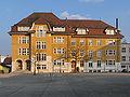
Town hall in Dietikon
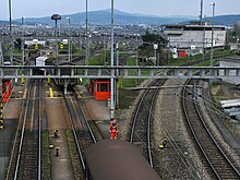
The classification yard RBL (Rangierbahnhof Limmattal)

St. Agatha, the Roman Catholic Church (built in 1927)

The Reformed church (built in 1925)
Dietikon has a population (as of 31 December 2017) of 27,079.[2] As of 2007[update], 39.8% of the population was made up of foreign nationals. As of 2008[update] the gender distribution of the population was 50% male and 50% female. Over the last 10 years the population has grown at a rate of 10.5%. Most of the population (as of 2000[update]) speaks German (73.9%), with Italian being second most common (8.9%) and Albanian being third (3.8%).
In the 2007 election the most popular party was the SVP which received 40.1% of the vote. The next three most popular parties were the SPS (19.9%), the CVP (13.7%) and the FDP (8%).
The age distribution of the population (as of 2000[update]) is children and teenagers (0–19 years old) make up 21.3% of the population, while adults (20–64 years old) make up 64.7% and seniors (over 64 years old) make up 14%. In Dietikon about 60.1% of the population (between age 25-64) have completed either non-mandatory upper secondary education or additional higher education (either university or a Fachhochschule). There are 9,892 households in Dietikon.[4]
Dietikon has an unemployment rate of 4.2%. As of 2005[update], there were 179 people employed in the primary economic sector and about 13 businesses involved in this sector. 2,613 people are employed in the secondary sector and there are 213 businesses in this sector. 10,632 people are employed in the tertiary sector, with 957 businesses in this sector.[3] As of 2007[update] 60.6% of the working population were employed full-time, and 39.4% were employed part-time.[4]
As of 2008[update] there were 8,655 Catholics and 4,599 Protestants in Dietikon. In the 2000 census[update], religion was broken down into several smaller categories. From the 2000 census, 26.5% were some type of Protestant, with 24.6% belonging to the Swiss Reformed Church and 1.9% belonging to other Protestant churches. 41.8% of the population were Catholic. Of the rest of the population, 12.2% were Muslim, 16.1% belonged to another religion (not listed), 4.6% did not give a religion, and 9.4% were atheist or agnostic.[4]
The historical population is given in the following table:[7]
| year | population |
|---|---|
| 1779 | 686 |
| 1836 | 1,025 |
| 1850 | 1,291 |
| 1900 | 2,613 |
| 1910 | 4,493 |
| 1950 | 7,132 |
| 1960 | 14,920 |
| 1970 | 22,705 |
| 1990 | 21,152 |
| 2000 | 21,353 |
| 2017 | 27,079 |
Economics and education
Among other companies, the Limmattaler Zeitung newspaper and Ex Libris are situated in Dietikon.
Weather
Dietikon has an average of 132.2 days of rain per year and on average receives 1,078 mm (42.4 in) of precipitation. The wettest month is August during which time Dietikon receives an average of 114 mm (4.5 in) of precipitation. During the wettest month, there is precipitation for an average of 12.7 days.[8]
Visitor attractions
There's the Bruno Weber Park in Dietikon respectively Spreitenbach, one of the few sculpture gardens and Gesamtkunstwerks in Switzerland.[9]Glanzenberg once was a settlement at the river Limmat, but its fortification seem never been completely built, so it may be destroyed in 1267/68, a legend tells. Its remain are in a little forest at the Limmat, opposite of the railway station of the same name, as well as the walls of the former Glanzenberg castle, built in the late 12th century AD by the Counts of Regensberg.
Personalities
- Markus Notter (* 21 November 1960), politician and former city president
Peter Schweri (* 20 June 1939 - 25 November 2016), artist, illustrator, objectartist
Bruno Weber (* 10 April 1931), architect and sculptor
Gallery
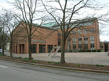
Zentralschulhaus building

Zürcherstrasse towards Schlieren

Protected area Dietiker & Geroldswiler Auen on the Limmat's shore

Hiking path at Glanzenberg train station
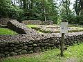
Ruins of the Schönenwerd water castle

Dietikon as part of the inscription at the Arc de Triomphe in Paris referring to the Second Battle of Zürich in 1799
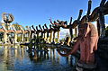
Bruno Weber Park

Earth house estate Lättenstrasse by Peter Vetsch


References
^ Arealstatistik Standard - Gemeindedaten nach 4 Hauptbereichen
^ ab Swiss Federal Statistical Office - STAT-TAB, online database – Ständige und nichtständige Wohnbevölkerung nach institutionellen Gliederungen, Geburtsort und Staatsangehörigkeit (in German) accessed 17 September 2018
^ ab Swiss Federal Statistical Office Archived January 5, 2016, at the Wayback Machine. accessed 05-Aug-2009
^ abcde Statistics Zurich (in German) accessed 4 August 2009
^ "Das kurze Leben des «Lisebethli»" [The short life of «Lisebethli»]. Neue Zürcher Zeitung (in German). 18 February 2002. Archived from the original on 28 November 2018. Retrieved 28 November 2018..mw-parser-output cite.citation{font-style:inherit}.mw-parser-output q{quotes:"""""""'""'"}.mw-parser-output code.cs1-code{color:inherit;background:inherit;border:inherit;padding:inherit}.mw-parser-output .cs1-lock-free a{background:url("//upload.wikimedia.org/wikipedia/commons/thumb/6/65/Lock-green.svg/9px-Lock-green.svg.png")no-repeat;background-position:right .1em center}.mw-parser-output .cs1-lock-limited a,.mw-parser-output .cs1-lock-registration a{background:url("//upload.wikimedia.org/wikipedia/commons/thumb/d/d6/Lock-gray-alt-2.svg/9px-Lock-gray-alt-2.svg.png")no-repeat;background-position:right .1em center}.mw-parser-output .cs1-lock-subscription a{background:url("//upload.wikimedia.org/wikipedia/commons/thumb/a/aa/Lock-red-alt-2.svg/9px-Lock-red-alt-2.svg.png")no-repeat;background-position:right .1em center}.mw-parser-output .cs1-subscription,.mw-parser-output .cs1-registration{color:#555}.mw-parser-output .cs1-subscription span,.mw-parser-output .cs1-registration span{border-bottom:1px dotted;cursor:help}.mw-parser-output .cs1-hidden-error{display:none;font-size:100%}.mw-parser-output .cs1-visible-error{font-size:100%}.mw-parser-output .cs1-subscription,.mw-parser-output .cs1-registration,.mw-parser-output .cs1-format{font-size:95%}.mw-parser-output .cs1-kern-left,.mw-parser-output .cs1-kern-wl-left{padding-left:0.2em}.mw-parser-output .cs1-kern-right,.mw-parser-output .cs1-kern-wl-right{padding-right:0.2em}
^ "Betrieb & Angebot" [Operation & Offer] (in German). Limmattalbahn AG. Archived from the original on 31 May 2018. Retrieved 31 May 2018.
^ ab Dietikon in German, French and Italian in the online Historical Dictionary of Switzerland.
^ "Temperature and Precipitation Average Values-Table, 1961-1990" (in German, French, and Italian). Federal Office of Meteorology and Climatology - MeteoSwiss. Archived from the original on 27 June 2009. Retrieved 8 May 2009., the weather station elevation is 385 meters above sea level.
^ Kathrin Fink (2014-08-31). "Künstlerfreunde glauben fest an die Zukunft des Bruno-Weber-Parks" (in German). Limmattaler Zeitung. Retrieved 2014-10-17.
External links
Official website (in German)
Dietikon in German, French and Italian in the online Historical Dictionary of Switzerland.
| Wikimedia Commons has media related to Dietikon. |
Municipalities in the district of Dietikon, Switzerland | ||
|---|---|---|
| ||
Authority control |
|
|---|


