Cantabrian Mountains
| Cantabrian Mountains | |
|---|---|
Spanish: Cordillera Cantábrica | |
 | |
| Highest point | |
| Peak | Torre de Cerredo |
| Elevation | 2,648 m (8,688 ft) |
| Coordinates | 43°11′51″N 04°51′06″W / 43.19750°N 4.85167°W / 43.19750; -4.85167 |
| Dimensions | |
| Length | 300 km (190 mi) WE |
| Width | 50 km (31 mi) NS |
| Naming | |
| Etymology | Named for Cantabria |
| Geography | |
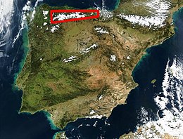 Location of the Cantabrian Mountains in northern Spain | |
| Country | Spain |
| Communities | Basque Country, Castile and León, Cantabria, Asturias |
| Range coordinates | 43°N 5°W / 43°N 5°W / 43; -5Coordinates: 43°N 5°W / 43°N 5°W / 43; -5 |
| Borders on | Pyrenees and Galicia |
| Geology | |
| Age of rock | Carboniferous, Paleozoic, Mesozoic |
| Type of rock | Limestone |
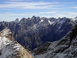
Torre de Cerredo (2,650 m.), the highest summit of the Cantabrian Mountains

Pico Espigüete(2,450 m.)
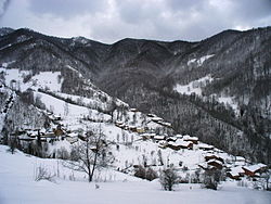
Typical Cantabrian Mountains landscape in winter
The Cantabrian Mountains or Cantabrian Range (Spanish: Cordillera Cantábrica) are one of the main systems of mountain ranges in Spain.
They stretch for over 300 km (180 miles) across northern Spain, from the western limit of the Pyrenees to the Galician Massif in Galicia, along the coast of the Cantabrian Sea. Their easternmost end meets the Sistema Ibérico.
These mountains are a distinct physiographic province of the larger Alpine System physiographic division.
The Cantabrian Mountains offer a wide range of trails for hiking, as well as many challenging climbing routes. Skiing is possible in the ski resorts of Alto Campoo, Valgrande-Pajares, Fuentes de Invierno, San isidro, Leitariegos and Manzaneda.
Contents
1 Geography
2 Main ranges
2.1 Western
2.2 Central
2.3 Eastern
3 Flora and fauna
4 Protected areas
5 References
6 Notes
7 External links
Geography
The Cantabrian Mountains stretch east-west, nearly parallel to the sea, as far as the pass of Leitariegos, also extending south between León and Galicia. The range's western boundary is marked by the valley of the river Minho (Spanish: Miño), by the lower Sil, which flows into the Miño, and by the Cabrera River, a small tributary of the Sil. Cantabrian mountains reach its south-western limit in Portugal.
As a whole, the Cantabrian Mountains are remarkable for their intricate ramifications, but almost everywhere, and especially in the east, it is possible to distinguish two principal ranges, from which the lesser ridges and mountain masses radiate. One range, or series of ranges, closely follows the outline of the coast; the other, which is loftier, forms the northern limit of the great tableland of Castile and León, and is sometimes regarded as a continuation of the Pyrenees. In some parts the coastal range rises sheer above the sea, and everywhere has so abrupt a declivity that the streams which flow seaward are all short and swift.
The descent from the southern range to the high plateaux of Castile is more gradual, and several large rivers, notably the Ebro, rise here and flow to the south or west. The breadth of the Cantabrian chain, with all its ramifications, increases from about 60 mi (97 km); in the east to about 115 mi (185 km) in the west. Many peaks are over 6000 ft high, but the greatest altitudes are attained in the central ridges on the borders of León, Asturias, Palencia and Cantabria. Here are the highest peak Torre de Cerredo (8,688 ft), Peña Vieja (8,579 ft), Peña Prieta (8,304 ft) and Espigüete (7,898 ft); an unnamed summit in the Picos de Europa, to which range the Peña Vieja also belongs, rises on the right bank of the Sella to a height of 8,045 ft; further west the peaks of Manpodres, Peña Ubiña, Peña Rubia and Cuiña all exceed 7,000 ft. A conspicuous feature of the chain, as of the adjacent tableland, is the number of its parameras, isolated plateaus shut in by lofty mountains or even by precipitous walls of rock.
The Cantabrian Mountains make a sharp divide between "Green Spain" to the north, and the dry central plateau. The north facing slopes receive heavy cyclonic rainfall from the Bay of Biscay, whereas the southern slopes are in rain shadow.
Main ranges
The Cantabrian Range has three very distinct sections from west to east:
Western
The Asturian Massif and its foothills. Geologically it is an eastern prolongation of the Galician Massif with Paleozoic folds. It is cut by deep east-west oriented canyons such as the Cares River valley. Highest point Torre de Cerredo 2,648 m.[1]
Sierra de la Bobia, Pico de la Bobia 1,201 m
Sierra de Tineo, Mulleiroso 1,241 m, a northern foothill located near Tineo
Sierra de San Isidro, Campo de La Vaga 1,078 m
Sierra de Eirelo, Pena dos Ladróis 800 m
Sierra del Sueve, Picu Pienzu 1,161 m, a northern foothill west of the Sella River
Sierra de Cuera, Pico Turbina 1,315 m, anorthern foothill located at the eastern end of Asturias
Sierra de Quintanal, running transversally on the eastern side of the Narcea River
- Other ranges of the Asturian Massif are: Sierra del Aramo, Sierra de Pando, Sierra de Caniellas, Sierra de Rañadoiro, Loma de Parrondo, Sierra de San Mamés, Sierra de Serrantina, Sierra de la Zarza, Sierra de Degaña, Sierra del Acebo, Sierra de Sobia, Cordal de Lena, Sierra de Casomera, Porrones de Moneo, and Cordal de Ponga
Central
The main mountains of this zone are the massive Picos de Europa. They are composed of Carboniferous limestone and marl.[2] The Paramo de Masa and La Lora grasslands are located in the south crossed by the Rudrón Valley.[3]
Sierra de Covadonga, west of the Picos de Europa
Sierra de Dobros, north of the Picos de Europa- The Picos de Europa are divided into three sectors or massifs:
Cornión Massif in the west, Torre Santa 2,596 m
Urrieles Massif in the center, Torrecerredo 2,650 m
Ándara Massif in the east, Morra de Lechugales 2,444 m
Sierra de Liencres, a coastal range, another northern foothill
Sierra Nedrina[4]
- Mountain ranges in Cantabria, located further east:
Fuentes Carrionas Massif, Peña Prieta 2,536 m, close to the eastern end of the Picos de Europa
Sierra Cocón above Tresviso
Sierra del Escudo de Cabuérniga, a northern foothill of the system, located between the main ridges and the sea[5]
Sierra de la Gándara, Peña Cabarga 537 m, a lower northern foothill located further east- Montes de Ucieda
- Alto del Gueto
- Sierra de la Matanza
Sierra de Peña Sagra, Peña Sagra 2,046 m
Sierra de Peña Labra, Pico Tres Mares 2,175 m and Peña Labra 2,006 m
Sierra del Cordel in the Saja and Nansa Comarca
Sierra del Escudo, between Campoo de Yuso and Luena
Sierra de Híjar, foothills located in the high plateau at the southeastern end of the central zone
- Valdecebollas
Sierra del Hornijo, Mortillano 1,410
Sierra de Breñas, foothill running perpendicular to the coast
Montes de Pas, Castro Valnera 1,707 m in the transition area to the Basque Mountains

Cantabrian brown bear, found across northern Spain mountains
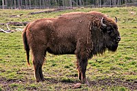
The Cantabrian Mountains has 2 reserves for the conservation of European bison. In Palencia and Asturias.
Eastern

The Iberian wolf is a subspecies of grey wolf that inhabits the forest and plains of northwestern Spain.
The Basque Mountains at the eastern end of the system, with very eroded Mesozoic folds and ranges of moderate height:
- Inner ranges:
Sierra Salbada (Orduña)- Mounts of Gasteiz, Kapildui 1,177 m
- Izki
Urbasa, Baiza 1,183 m
Andía, with the impressive Beriain 1,493 m
- Coastal ranges:
Gorbea (Gorbeia) 1,481 m
Urkiola, Anboto 1,331 m- Elgea
Aizkorri, Aitxuri 1,551 m, highest peak in the Basque Mountains
Altzania, Aratz 1,442 m
Aralar, Txindoki 1,346 m- Other important mountains close to the sea include Ganekogorta, Oiz, Sollube, Arrate, Kalamua and Hernio
Flora and fauna

Typical wooded area in the Cantabrian Mountains
The Cantabrian Mountains are home to an important variety of plant life, as well as the Cantabrian brown bear (Ursus arctos pyrenaicus), catalogued as being in danger of extinction, which extends from Asturias (the region where its population is bigger) to areas in Léon, Palencia and Cantabria, and the Cantabrian Capercaillie (T. urogallus cantabricus).
Other animals associated with the range include the Iberian wolf (Canis lupus signatus) and the rebeco, or Cantabrian chamois (Rupicapra pyrenaica parva).
Woodland in the Cantabrian Mountains is generally predominated by beeches (Fagus sylvatica).
Protected areas
The Cantabrian mountain range includes several protected areas such as the Picos de Europa National Park, which is one of several Cantabrian parks included in UNESCO's World Network of Biosphere Reserves. Some of the sites are included in the European Union's Natura 2000 network and Special Protection Areas for the Conservation of Wild Birds.
- Picos de Europa National Park
- Muniellos Nature Reserve
- Natural Park of Fuentes del Narcea, Degaña e Ibias
- Redes Natural Park
- Somiedo Natural Park
- Protected Landscape Area of Sierra del Sueve
- Natural Park of Fuentes Carrionas and Fuente Cobre-Montaña Palentina
- Saja-Besaya Natural Park
- Collados del Asón Natural Park
- Ojo Guareña
References
^ La Cordillera Cantábrica
^ Geología de Cantabria Archived 2014-07-14 at the Wayback Machine.
^ J. Muñoz Jiménez, Geografía de Asturias. 1 . Geografía física. El relieve, el clima y las aguas. 1982
^ Naturaleza en Asturias[permanent dead link]
^ Estudio de caudales ecológicos en la red hidrográfica de Cantabria Archived 2013-06-26 at the Wayback Machine.
Notes
 This article incorporates text from a publication now in the public domain: Chisholm, Hugh, ed. (1911). "Cantabrian Mountains". Encyclopædia Britannica (11th ed.). Cambridge University Press..mw-parser-output cite.citation{font-style:inherit}.mw-parser-output q{quotes:"""""""'""'"}.mw-parser-output code.cs1-code{color:inherit;background:inherit;border:inherit;padding:inherit}.mw-parser-output .cs1-lock-free a{background:url("//upload.wikimedia.org/wikipedia/commons/thumb/6/65/Lock-green.svg/9px-Lock-green.svg.png")no-repeat;background-position:right .1em center}.mw-parser-output .cs1-lock-limited a,.mw-parser-output .cs1-lock-registration a{background:url("//upload.wikimedia.org/wikipedia/commons/thumb/d/d6/Lock-gray-alt-2.svg/9px-Lock-gray-alt-2.svg.png")no-repeat;background-position:right .1em center}.mw-parser-output .cs1-lock-subscription a{background:url("//upload.wikimedia.org/wikipedia/commons/thumb/a/aa/Lock-red-alt-2.svg/9px-Lock-red-alt-2.svg.png")no-repeat;background-position:right .1em center}.mw-parser-output .cs1-subscription,.mw-parser-output .cs1-registration{color:#555}.mw-parser-output .cs1-subscription span,.mw-parser-output .cs1-registration span{border-bottom:1px dotted;cursor:help}.mw-parser-output .cs1-hidden-error{display:none;font-size:100%}.mw-parser-output .cs1-visible-error{font-size:100%}.mw-parser-output .cs1-subscription,.mw-parser-output .cs1-registration,.mw-parser-output .cs1-format{font-size:95%}.mw-parser-output .cs1-kern-left,.mw-parser-output .cs1-kern-wl-left{padding-left:0.2em}.mw-parser-output .cs1-kern-right,.mw-parser-output .cs1-kern-wl-right{padding-right:0.2em}
External links
 Media related to Cantabrian Mountain Range at Wikimedia Commons
- iberianature.com - English-language web site on nature in Spain and Portugal
- Cantabrian Institute of Biodiversity
- Parque Natural de Las Ubiñas-La Mesa - Reserva de la Biosfera (I)
Geography topics | |||||||
|---|---|---|---|---|---|---|---|
| |||||||
| Branches |
| ||||||
| Techniques and tools |
| ||||||
| Institutions |
| ||||||
| Education |
| ||||||
| |||||||
Physical geography | ||
|---|---|---|
|  | |
| ||
Mountain ranges of Spain | ||
|---|---|---|
| ||


