Reinbeck, Iowa
| Reinbeck, Iowa | |
|---|---|
| City | |
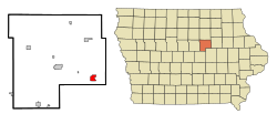 Location of Reinbeck, Iowa | |
| Coordinates: 42°19′20″N 92°35′55″W / 42.32222°N 92.59861°W / 42.32222; -92.59861Coordinates: 42°19′20″N 92°35′55″W / 42.32222°N 92.59861°W / 42.32222; -92.59861 | |
| Country | |
| State | |
| County | Grundy |
| Area[1] | |
| • Total | 1.82 sq mi (4.71 km2) |
| • Land | 1.82 sq mi (4.71 km2) |
| • Water | 0 sq mi (0 km2) |
| Elevation | 958 ft (293 m) |
| Population (2010)[2] | |
| • Total | 1,664 |
| • Estimate (2016)[3] | 1,635 |
| • Density | 914/sq mi (353.0/km2) |
| Time zone | UTC-6 (Central (CST)) |
| • Summer (DST) | UTC-5 (CDT) |
| ZIP code | 50669 |
| Area code(s) | 319 |
| FIPS code | 19-66315 |
GNIS feature ID | 0460580 |
Reinbeck is a city in Grundy County, Iowa, United States. The population was 1,664 at the 2010 census—a five percent decrease from the population of 1,751 at the 2000 census. It is part of the Waterloo–Cedar Falls Metropolitan Statistical Area and is in the Cedar Valley.
Contents
1 Geography
2 Recreation
3 Demographics
3.1 2010 census
3.2 2000 census
4 Education
5 References
6 External links
Geography
Reinbeck is located at 42°19′20″N 92°35′55″W / 42.32222°N 92.59861°W / 42.32222; -92.59861 (42.322218, -92.598696),[4] along Iowa Highway 175.
According to the United States Census Bureau, the city has a total area of 1.82 square miles (4.71 km2), all of it land.[1]
Recreation
Reinbeck is host to a golf course, various sports fields, a bike trail and hunting range, and a swimming pool. The pool features a zero depth entry zone, a high board and a low board, a water slide, in addition to changing rooms and a concession stand.
Demographics
| Historical populations | ||
|---|---|---|
| Year | Pop. | ±% |
| 1880 | 482 | — |
| 1890 | 731 | +51.7% |
| 1900 | 1,203 | +64.6% |
| 1910 | 1,205 | +0.2% |
| 1920 | 1,415 | +17.4% |
| 1930 | 1,425 | +0.7% |
| 1940 | 1,429 | +0.3% |
| 1950 | 1,460 | +2.2% |
| 1960 | 1,621 | +11.0% |
| 1970 | 1,711 | +5.6% |
| 1980 | 1,808 | +5.7% |
| 1990 | 1,605 | −11.2% |
| 2000 | 1,751 | +9.1% |
| 2010 | 1,664 | −5.0% |
| 2016 | 1,635 | −1.7% |
| Source:"American FactFinder". United States Census Bureau..mw-parser-output cite.citation{font-style:inherit}.mw-parser-output q{quotes:"""""""'""'"}.mw-parser-output code.cs1-code{color:inherit;background:inherit;border:inherit;padding:inherit}.mw-parser-output .cs1-lock-free a{background:url("//upload.wikimedia.org/wikipedia/commons/thumb/6/65/Lock-green.svg/9px-Lock-green.svg.png")no-repeat;background-position:right .1em center}.mw-parser-output .cs1-lock-limited a,.mw-parser-output .cs1-lock-registration a{background:url("//upload.wikimedia.org/wikipedia/commons/thumb/d/d6/Lock-gray-alt-2.svg/9px-Lock-gray-alt-2.svg.png")no-repeat;background-position:right .1em center}.mw-parser-output .cs1-lock-subscription a{background:url("//upload.wikimedia.org/wikipedia/commons/thumb/a/aa/Lock-red-alt-2.svg/9px-Lock-red-alt-2.svg.png")no-repeat;background-position:right .1em center}.mw-parser-output .cs1-subscription,.mw-parser-output .cs1-registration{color:#555}.mw-parser-output .cs1-subscription span,.mw-parser-output .cs1-registration span{border-bottom:1px dotted;cursor:help}.mw-parser-output .cs1-hidden-error{display:none;font-size:100%}.mw-parser-output .cs1-visible-error{font-size:100%}.mw-parser-output .cs1-subscription,.mw-parser-output .cs1-registration,.mw-parser-output .cs1-format{font-size:95%}.mw-parser-output .cs1-kern-left,.mw-parser-output .cs1-kern-wl-left{padding-left:0.2em}.mw-parser-output .cs1-kern-right,.mw-parser-output .cs1-kern-wl-right{padding-right:0.2em} and Iowa Data Center Source: U.S. Decennial Census[5] | ||
2010 census
As of the census[2] of 2010, there were 1,664 people, 738 households, and 468 families residing in the city. The population density was 914.3 inhabitants per square mile (353.0/km2). There were 802 housing units at an average density of 440.7 per square mile (170.2/km2). The racial makeup of the city was 98.7% White, 0.2% African American, 0.1% Native American, 0.1% Asian, 0.5% from other races, and 0.4% from two or more races. Hispanic or Latino of any race were 1.1% of the population.
There were 738 households of which 25.7% had children under the age of 18 living with them, 52.4% were married couples living together, 6.9% had a female householder with no husband present, 4.1% had a male householder with no wife present, and 36.6% were non-families. 32.0% of all households were made up of individuals and 18.7% had someone living alone who was 65 years of age or older. The average household size was 2.20 and the average family size was 2.72.
The median age in the city was 45.1 years. 20.9% of residents were under the age of 18; 7.8% were between the ages of 18 and 24; 21.2% were from 25 to 44; 26% were from 45 to 64; and 24% were 65 years of age or older. The gender makeup of the city was 48.5% male and 51.5% female.
2000 census
As of the census[6] of 2000, there were 1,751 people, 730 households, and 492 families residing in the city. The population density was 962.5 people per square mile (371.5/km²). There were 769 housing units at an average density of 422.7 per square mile (163.1/km²). The racial makeup of the city was 99.60% White, 0.11% African American, 0.17% Asian, 0.06% from other races, and 0.06% from two or more races. Hispanic or Latino of any race were 0.40% of the population.
There were 730 households out of which 28.2% had children under the age of 18 living with them, 58.8% were married couples living together, 6.7% had a female householder with no husband present, and 32.6% were non-families. 29.9% of all households were made up of individuals and 17.8% had someone living alone who was 65 years of age or older. The average household size was 2.33 and the average family size was 2.87.
23.5% were under the age of 18, 6.3% from 18 to 24, 25.3% from 25 to 44, 21.5% from 45 to 64, and 23.4% were 65 years of age or older. The median age was 42 years. For every 100 females, there were 90.5 males. For every 100 females age 18 and over, there were 84.6 males.
The median income for a household in the city was $36,667, and the median income for a family was $45,938. Males had a median income of $32,829 versus $21,618 for females. The per capita income for the city was $19,814. About 3.3% of families and 4.0% of the population were below the poverty line, including 2.3% of those under age 18 and 6.1% of those age 65 or over.
Education
The city is served by the Gladbrook-Reinbeck Community School District,[7] known as Gladbrook-Reinbeck school district or "G-R" as the locals refer to it. The G-R mascot is the Rebel.[8]
The city was served by the Reinbeck Community School District until it consolidated on July 1, 1998.[9]
References
^ ab "US Gazetteer files 2010". United States Census Bureau. Archived from the original on 2011-02-20. Retrieved 2012-05-11.
^ ab "American FactFinder". United States Census Bureau. Retrieved 2012-05-11.
^ "Population and Housing Unit Estimates". Retrieved June 9, 2017.
^ "US Gazetteer files: 2010, 2000, and 1990". United States Census Bureau. 2011-02-12. Retrieved 2011-04-23.
^ "Census of Population and Housing". Census.gov. Retrieved June 4, 2015.
^ "American FactFinder". United States Census Bureau. Retrieved 2008-01-31.
^ "Gladbrook-Reinbeck." Iowa Department of Education. Retrieved on July 15, 2018.
^ "Gladbrook - Reinbeck Community Schools". Home of the Rebels. Retrieved 2011-09-24.
^ "REORGANIZATION & DISSOLUTION ACTIONS SINCE 1965-66." Iowa Department of Education. Retrieved on July 20, 2018.
External links
| Wikimedia Commons has media related to Reinbeck, Iowa. |
City-Data Comprehensive statistical data and more about Reinbeck
Municipalities and communities of Grundy County, Iowa, United States | ||
|---|---|---|
County seat: Grundy Center | ||
| Cities |
| |
| Unincorporated communities |
| |


