Uwajima, Ehime
Uwajima .mw-parser-output .nobold{font-weight:normal} 宇和島市 | |
|---|---|
City | |
 View of Uwajima Bay and downtown Uwajima from Uwajima Castle | |
 Flag  Emblem | |
 Location of Uwajima in Ehime Prefecture | |
 Uwajima Location in Japan | |
| Coordinates: 33°13′N 132°34′E / 33.217°N 132.567°E / 33.217; 132.567Coordinates: 33°13′N 132°34′E / 33.217°N 132.567°E / 33.217; 132.567 | |
| Country | Japan |
| Region | Shikoku |
| Prefecture | Ehime Prefecture |
| Government | |
| • Mayor | Hirohisa Ishibashi (since February 2001) |
| Area | |
| • Total | 469.48 km2 (181.27 sq mi) |
| Population (October 1, 2010) | |
| • Total | 86,631 |
| • Density | 184.53/km2 (477.9/sq mi) |
| Symbols | |
| • Tree | Querus phillyraeoides |
| • Flower | Citrus unshiu |
| Time zone | UTC+9 (JST) |
| City hall address | 1 Akebonochō, Uwajima-shi, Ehime-ken 798-8601 |
| Website | www.city.uwajima.ehime.jp |
Uwajima (宇和島市, Uwajima-shi) is a city located in Ehime Prefecture, Japan.
As of October 1, 2010, the city has an estimated population of 86,631 and a population density of 184.53 persons per km². The total area is 469.48 km².
In 1595, what is now Uwajima was known as Itajima Village. Takatora Tohdo became lord of the Uwa region, and ordered the restoration of Marugushi Castle. The city was founded by the mergers of the city of Uwajima and parts of former Kitauwa District.
After Date Hidemune, the eldest son of Date Masamune, a prominent lord in northern Japan, took over Uwa in 1614, the clan strongly promoted Uwajima Castle as a center of industry, education, and culture.
In 1871 Uwa became Uwajima Prefecture. The following year it was renamed Kamiyama Prefecture. In 1873, Kamiyama Prefecture was combined with Ishizuchi Prefecture. After Ehime Prefecture was established, the capital was moved to Matsuyama to the north.
Contents
1 Municipal timeline
1.1 Before the city
1.2 After becoming a city
1.3 After the second founding
2 Climate
3 Attractions
3.1 Tsushima
4 Gallery
5 See also
6 References
7 External links
Municipal timeline
Before the city
- 1889: The town system began
- 1917: Maruho Village was merged into Uwajima
After becoming a city
- 1921: The city of Uwajima was founded after annexing the village of Yahata
- 1934: The city was extended by combining Kushima Village in 1934 and renovating the bay area for factory usage
- 1945: The center of the city was largely destroyed by bombing. However, post-war reconstruction was remarkable, and the city recovered admirably.
- 1955: Miura and Takamitsu Villages were merged
- 1974: Uwaumi Village was merged
After the second founding
- August 1, 2005: Uwajima absorbed the towns of Mima, Tsushima and Yoshida (all from Kitauwa District) to create the new and expanded city of Uwajima.
Climate
Uwajima has a humid subtropical climate (Köppen climate classification Cfa) with hot summers and cool winters. Precipitation is significant throughout the year, but is highest from June to September.
| Climate data for Uwajima, Ehime (1981 - 2010, elevation 2.4 m (7.9 ft)) | |||||||||||||
|---|---|---|---|---|---|---|---|---|---|---|---|---|---|
| Month | Jan | Feb | Mar | Apr | May | Jun | Jul | Aug | Sep | Oct | Nov | Dec | Year |
| Record high °C (°F) | 22.5 (72.5) | 23.7 (74.7) | 26.8 (80.2) | 30.0 (86.0) | 31.4 (88.5) | 35.9 (96.6) | 40.2 (104.4) | 38.4 (101.1) | 36.1 (97.0) | 33.0 (91.4) | 28.2 (82.8) | 24.3 (75.7) | 40.2 (104.4) |
| Average high °C (°F) | 11.2 (52.2) | 12.0 (53.6) | 15.0 (59.0) | 20.2 (68.4) | 23.8 (74.8) | 26.8 (80.2) | 30.6 (87.1) | 32.0 (89.6) | 28.9 (84.0) | 23.9 (75.0) | 18.9 (66.0) | 13.8 (56.8) | 21.4 (70.6) |
| Daily mean °C (°F) | 6.8 (44.2) | 7.4 (45.3) | 10.3 (50.5) | 15.1 (59.2) | 19.2 (66.6) | 22.7 (72.9) | 26.5 (79.7) | 27.5 (81.5) | 24.4 (75.9) | 18.8 (65.8) | 13.9 (57.0) | 8.9 (48.0) | 16.8 (62.2) |
| Average low °C (°F) | 2.7 (36.9) | 3.0 (37.4) | 5.7 (42.3) | 10.2 (50.4) | 14.6 (58.3) | 19.1 (66.4) | 23.2 (73.8) | 24.0 (75.2) | 20.8 (69.4) | 14.6 (58.3) | 9.6 (49.3) | 4.8 (40.6) | 12.7 (54.9) |
| Record low °C (°F) | −5.6 (21.9) | −6.2 (20.8) | −4.2 (24.4) | −0.7 (30.7) | 2.8 (37.0) | 9.0 (48.2) | 14.5 (58.1) | 16.2 (61.2) | 8.7 (47.7) | 2.9 (37.2) | −0.4 (31.3) | −3.3 (26.1) | −6.2 (20.8) |
| Average precipitation mm (inches) | 60.4 (2.38) | 71.2 (2.80) | 117.0 (4.61) | 119.4 (4.70) | 160.4 (6.31) | 258.3 (10.17) | 237.2 (9.34) | 176.2 (6.94) | 203.2 (8.00) | 110.8 (4.36) | 81.4 (3.20) | 53.0 (2.09) | 1,648.5 (64.9) |
| Mean monthly sunshine hours | 111.2 | 131.1 | 156.1 | 181.8 | 190.6 | 150.5 | 200.6 | 224.7 | 169.6 | 173.8 | 132.0 | 119.0 | 1,941 |
| Source #1: Japan Meteorological Agency[1] | |||||||||||||
| Source #2: Japan Meteorological Agency[2] | |||||||||||||
Attractions
Uwajima has a Date Family Museum[3] which features many historically important objects tied to the history of the region and the Daimyō family Date which ruled this area.
Uwajima Castle is well known as one of the 12 Japanese castles to have an original donjon built in the Edo Period.
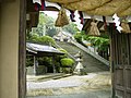
Uwajima is home to an unusual fertility shrine called Taga Shrine, which features a large, realistic phallus carved from a log approximately 9 feet in length, 1 foot in diameter. Next to the shrine is a graphic sex museum, filled with artifacts and paintings from around the world.

A mask of the Cow Demon (牛鬼, ushioni), one of the many used at the bullfighting festival.
Every July a festival is held in Uwajima known as the Uwajima Ushi-oni Festival, "Gaiya Festival," or the "Warei Shrine Festival." Among the festivities are ushioni teams parading down the street, a dance contest to the town song known as the "Gaiya" dance, traditional dancing, and a bullfight. The word "Gaiya" is in a local dialect, approximately translating to "awesome" in English.
The city is known for bullfighting, which differs from the more widely known Spanish bullfights in that there is no matador. Two bulls fight in a ring until one bull's knees touch the ground or flees, marking it the loser. Bullfights are generally held in January, April, July, and August.
Kyoichi Katayama, the author of the novel Socrates in Love, is from Uwajima. The novel was turned into a movie.
Shinro Ohtake, a contemporary Japanese artist, has lived and worked in Uwajima since 1987.
A local product (meibutsu) of Uwajima is jakoten, a type of fried kamaboko.
Tsushima
Tsushima occupies an area of approximately 200 km² and has a significant proportion of Uwajima's current land area, despite not being highly populated (fewer than 15,000 people). It's made up of small villages that shared a municipal government as Tsushima until they were amalgamated into Uwajima.
Tsushima is known for the Iwamatsu River and its annual festival where people eat tiny, live fish, as well as pearl and fish farming. It is part of the prefecture's mikan industry.
Gallery
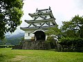
Uwajima Castle

Uwajima as viewed from the castle
Warei Shrine

Taga Shrine statues


See also
- Date Munenari
- Iyo Province
- Uwajima Domain
- Akinori Iwamura
References
^ 宇和島 平年値(年・月ごとの値) 主な要素 (in Japanese). Japan Meteorological Agency. Retrieved 15 May 2018..mw-parser-output cite.citation{font-style:inherit}.mw-parser-output .citation q{quotes:"""""""'""'"}.mw-parser-output .citation .cs1-lock-free a{background:url("//upload.wikimedia.org/wikipedia/commons/thumb/6/65/Lock-green.svg/9px-Lock-green.svg.png")no-repeat;background-position:right .1em center}.mw-parser-output .citation .cs1-lock-limited a,.mw-parser-output .citation .cs1-lock-registration a{background:url("//upload.wikimedia.org/wikipedia/commons/thumb/d/d6/Lock-gray-alt-2.svg/9px-Lock-gray-alt-2.svg.png")no-repeat;background-position:right .1em center}.mw-parser-output .citation .cs1-lock-subscription a{background:url("//upload.wikimedia.org/wikipedia/commons/thumb/a/aa/Lock-red-alt-2.svg/9px-Lock-red-alt-2.svg.png")no-repeat;background-position:right .1em center}.mw-parser-output .cs1-subscription,.mw-parser-output .cs1-registration{color:#555}.mw-parser-output .cs1-subscription span,.mw-parser-output .cs1-registration span{border-bottom:1px dotted;cursor:help}.mw-parser-output .cs1-ws-icon a{background:url("//upload.wikimedia.org/wikipedia/commons/thumb/4/4c/Wikisource-logo.svg/12px-Wikisource-logo.svg.png")no-repeat;background-position:right .1em center}.mw-parser-output code.cs1-code{color:inherit;background:inherit;border:inherit;padding:inherit}.mw-parser-output .cs1-hidden-error{display:none;font-size:100%}.mw-parser-output .cs1-visible-error{font-size:100%}.mw-parser-output .cs1-maint{display:none;color:#33aa33;margin-left:0.3em}.mw-parser-output .cs1-subscription,.mw-parser-output .cs1-registration,.mw-parser-output .cs1-format{font-size:95%}.mw-parser-output .cs1-kern-left,.mw-parser-output .cs1-kern-wl-left{padding-left:0.2em}.mw-parser-output .cs1-kern-right,.mw-parser-output .cs1-kern-wl-right{padding-right:0.2em}
^ 宇和島(愛媛県) 主な要素 (in Japanese). Japan Meteorological Agency. Retrieved 15 May 2018.
^ http://www.city.uwajima.ehime.jp/datehaku
External links
| Wikimedia Commons has media related to Uwajima, Ehime. |
| Wikivoyage has a travel guide for Uwajima. |
Uwajima City official website (in Japanese)
Nanrakuen Website (in Japanese)
- Ehime Tourism Information: Uwajima
Matsuyama (capital) | ||
| Core city |
| |
| Cities |
| |
| Districts |
| |
List of mergers in Ehime Prefecture | ||
Authority control |
|
|---|


