Alexandria Port
| Port of Alexandria | |
|---|---|
| Location | |
| Country | Egypt |
| Location | Alexandria |
| Coordinates | 31°12′16″N 29°52′48″E / 31.2045796°N 29.8800659°E / 31.2045796; 29.8800659 |
| Details | |
| Operated by | Alexandria Port Authority |
| Type of harbor | 6.8 Km2 |
| Size of harbor | 16 Km2 |
| Land area | 22.8 Km2 |
| Available berths | 67 |
| Statistics | |
| Annual cargo tonnage | 17,627,762 (2012) |
| Annual container volume | 1,442,712 (2012) |
Website Official website | |
The Port of Alexandria is on the West Verge of the Nile Delta between the Mediterranean Sea and Mariut Lake in Alexandria, Egypt and is considered the second most important city and the main port in Egypt. Alexandria port consists of two harbours (East and West) separated by a T-shaped peninsula. The East harbour is shallow and is not navigable by large vessels. The West harbour is used for commercial shipping. The harbour is formed by two converging breakwaters.
Contents
1 History
1.1 Ancient times
1.2 Modern era
2 Geography
3 See also
4 References
5 External links
History
Ancient times
Alexandria Port is one of the oldest ports in the world. The earliest port facilities were built in 1900 BC in the then-village of Rhakotis, to service coastal shipping and supply the island of Pharos (now part of the "Ras al-Tin" quarter).
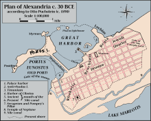
Plan of Alexandria c. 30 BC
Over the centuries sand and silt deposits made the port unnavigable. It was cleared by forces under the command of Alexander the Great in 331 BC as part of the construction of Alexandria city to be the marine base for his fleet. Alexander's engineer Dinocrat linked the port of Alexandria and the island of Pharos with a bridge 1200 meters long and 200 meters wide, creating two harbour basins for commercial and military shipping. The northeast basin (Portus Magnus, currently the Eastern harbour) was designed for military vessels and the southwest basin (Portus Eunostus, currently the main port of Alexandria) was for commercial use. In the Ptolemy era a second bridge was built to Pharos, further dividing the eastern harbour into two separate inlets.
According to Strabo, Alexandria had an inland harbour on Lake Mareotis as well as the harbours on the Mediterranean. The lake had no mouth connecting it to the sea but was instead connected to the Nile by canals. Strabo describes the lake harbour as being busier than the harbours on the sea.[1] During the period of Roman Egypt, grain was exported in large quantities from the city's Western Harbour, earning it the name "Portus Magnus". The grain was brought down the Nile by barge and stored in large granaries near the shore of Lake Mareotis before shipping. At the height of the Roman Empire, Alexandria was shipping 83,000 tons of grain per year to Rome. By the time of the late Empire, the city was shipping 220,000 tons of grain per year to Constantinople.[2]
Modern era
Muhammad Ali of Egypt issued the order to restore and partly retrace the freshwater canal from the Nile upon his ascension to power. On its completion in 1820 it was named the Mahmoudiyah Canal. Under Muhammad Ali's rule, Alexandria shipyard was founded.
During World War I, the British Mediterranean Expeditionary Force that took part in the Gallipoli Campaign used the established port of Alexandria as its main base for troops and supplies bound for the landing at Cape Helles.[3]
By the late 20th century sea trade through the Port of Alexandria was exceeding its capacity. A new port was built at El-Dekheila during the 1980s with facilities for container shipping and infrastructure to serve the nearby steel factory. In addition to the Port of Dekheila and the Western Port of Alexandria, the city's ports include those at Abu Qir and Sidi Krer, as well as Alexandria's old Eastern Port which is no longer used for shipping freight.[4]
Egypt has a total of 15 commercial ports along the Mediterranean and Red Sea coasts. Alexandria Port, controlled by the Alexandria Port Authority, is the country's largest and it handles approximately 55% of Egypt's international trade.[5] Overall Alexandria's various harbours handle over three quarters of Egypt's foreign trade, with nearly 80% of the country's imports and exports passing through the city.[6]
Geography
The western port is divided into several zones:
- Used for general cargo handling.
- Deals with four types of activities: unified cargoes including a Ro Ro and passenger terminal, stuffed bulk cargoes, and barge discharge.
- Used for handling general cargo and barge discharge.
- Used for handling containers, cement, coal, barge discharge, fertilizers, and general cargo.
- Used for handling: molasses, timber, some types of general cargoes, barge discharge, grains and flour.
- (Oil Dock): Situated at the western boundaries of the port, is used for handling edible oil, oil products and for providing bunkers. It also includes berths used for handling livestock. The port does not include oil storage facilities, but oil berths are connected to a refinery through a 2 km long pipeline.
See also
- Transportation in Alexandria
References
^ Cooper, John (2014). The Medieval Nile: Route, Navigation, and Landscape in Islamic Egypt. The American University in Cairo Press. p. 69. ISBN 9789774166143..mw-parser-output cite.citation{font-style:inherit}.mw-parser-output .citation q{quotes:"""""""'""'"}.mw-parser-output .citation .cs1-lock-free a{background:url("//upload.wikimedia.org/wikipedia/commons/thumb/6/65/Lock-green.svg/9px-Lock-green.svg.png")no-repeat;background-position:right .1em center}.mw-parser-output .citation .cs1-lock-limited a,.mw-parser-output .citation .cs1-lock-registration a{background:url("//upload.wikimedia.org/wikipedia/commons/thumb/d/d6/Lock-gray-alt-2.svg/9px-Lock-gray-alt-2.svg.png")no-repeat;background-position:right .1em center}.mw-parser-output .citation .cs1-lock-subscription a{background:url("//upload.wikimedia.org/wikipedia/commons/thumb/a/aa/Lock-red-alt-2.svg/9px-Lock-red-alt-2.svg.png")no-repeat;background-position:right .1em center}.mw-parser-output .cs1-subscription,.mw-parser-output .cs1-registration{color:#555}.mw-parser-output .cs1-subscription span,.mw-parser-output .cs1-registration span{border-bottom:1px dotted;cursor:help}.mw-parser-output .cs1-ws-icon a{background:url("//upload.wikimedia.org/wikipedia/commons/thumb/4/4c/Wikisource-logo.svg/12px-Wikisource-logo.svg.png")no-repeat;background-position:right .1em center}.mw-parser-output code.cs1-code{color:inherit;background:inherit;border:inherit;padding:inherit}.mw-parser-output .cs1-hidden-error{display:none;font-size:100%}.mw-parser-output .cs1-visible-error{font-size:100%}.mw-parser-output .cs1-maint{display:none;color:#33aa33;margin-left:0.3em}.mw-parser-output .cs1-subscription,.mw-parser-output .cs1-registration,.mw-parser-output .cs1-format{font-size:95%}.mw-parser-output .cs1-kern-left,.mw-parser-output .cs1-kern-wl-left{padding-left:0.2em}.mw-parser-output .cs1-kern-right,.mw-parser-output .cs1-kern-wl-right{padding-right:0.2em}
^ Haas, Christopher (2006). Alexandria in Late Antiquity: Topography and Social Conflict. Johns Hopkins University Press. p. 42–43. ISBN 9780801885419.
^ Crawley, Rhys (2014). Climax at Gallipoli: The Failure of the August Offensive. Campaigns and Commanders Series. Volume 42. University of Oklahoma Press. p. 128. ISBN 9780806145280.
^ Ibrahim, Fouad N.; Ibrahim, Barbara (2003). Egypt: An Economic Geography. International library of human geography. Volume 1. I.B.Tauris. p. 231. ISBN 9781860645471.
^ Jeffreys, Andrew, ed. (2011). The Report: Egypt 2011. Oxford Business Group. p. 103. ISBN 9781907065408.
^ Christopher, Paul J. (2006). Greatest Cities in the World You Should Visit. 50 Plus One Series. Encouragement Press. p. 10. ISBN 9781933766010.
External links
- The official site of the Alexandria Port Authority
Map of Alexandria port, 1817. Eran Laor Cartographic Collection, The National Library of Israel.


