Mingenew, Western Australia
Mingenew Western Australia | |
|---|---|
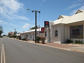 Mingenew's main street. | |
 Mingenew | |
| Coordinates | 29°11′38″S 115°26′28″E / 29.19389°S 115.44111°E / -29.19389; 115.44111Coordinates: 29°11′38″S 115°26′28″E / 29.19389°S 115.44111°E / -29.19389; 115.44111 |
| Population | 283 (2006 census)[1] |
| Established | 1906 |
| Postcode(s) | 6522 |
| Elevation | 156 m (512 ft) |
| Location |
|
| LGA(s) | Shire of Mingenew |
| State electorate(s) | Moore |
| Federal Division(s) | Durack |
Mingenew is a town in Western Australia, located 383 kilometres (238 mi) north of the state capital, Perth. It is the seat of government for the Shire of Mingenew.
Contents
1 History
2 Agriculture
3 Attractions
3.1 Wildflowers
3.1.1 Coalseam Conservation Park
3.2 Sports Clubs
4 References
5 Further reading
6 External links
History
Mingenew was named after Mingenew Spring, an Aboriginal word recorded by European settlers in 1856,[2] possibly deriving from either the words Minganu "the place of many ants" or Mininoo "the place of many waters".[3] Mingenew and the surrounding Irwin District were first explored by the brothers Augustus Charles and Francis Thomas Gregory in August 1847, looking for suitable grazing land. Settlement of the district then occurred in the 1850s because it was ideal country for cattle.[2] The Midland Railway opened in August 1891 and private land was subdivided, followed in 1906 by subdivision of Government land.[2] In 1906, the town of Mingenew was gazetted.[2]
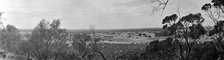
1920s panorama of Mingenew, taken from Mingenew Hill, overlooking the town

Current panorama of Mingenew, also taken from Mingenew Hill
Agriculture
Today, the town's economy is based on the farming of sheep, wheat and lupins.[4]
Mingenew is known as The Grain Centre. The Mingenew grain facility (CBH, Co-operative Bulk Handling) is recognised as the largest inland grower fed receival site[5] facility in the Southern Hemisphere, with a holding capacity of 403,000 tons.[6] There is a giant Wheat Stalk Sculpture at Cecil Newton Park in the main street of the town, which is affectionately known as "Big Ears" by the locals, and emphasises the importance of wheat farming in the area.
Attractions
Wildflowers

A pink everlasting or Rhodanthe chlorocephala rosea
Mingenew has many spectacular displays of wildflowers between late July to early October. Varieties include everlastings, hakeas, banksias and grevilleas. Mingenew is in the heart of the Western Australia’s "Wildflower Country".[7]
Mingenew’s floral emblem is the Bird Beak Hakea (Hakea orthorrhyncha).
Coalseam Conservation Park
Located 33 km north east of Mingenew, the Coalseam Conservation Park is a renowned site for its carpets of native pink and white everlastings (Rhodanthe chlorocephala ss. rosea) and yellow pom pom (Cephalipterum drummondii) wildflowers. The area was named the Coalseam after the Gregory brothers discovered coal exposed within the sedimentary layers of the banks of the Irwin River in 1846. This marked the first discovery of coal in Western Australia, however, after a number of shafts were dug, only narrow seams of poor quality coal were found; thus the site was abandoned. The park is now a popular picnic place, where remnants of its mining history are still present as well as the many marine fossils embedded in the riverbank and the magnificent limestone cliffs from the Permian Ice Age, 250 million years ago – the oldest geological era.[8]
Sports Clubs
Sport is an integral part of the fabric to the community of Mingenew.
- Mingenew Football Club
- Mingenew Hockey Club
- Mingenew Netball Club
- Mingenew Tennis Club
- Mingenew Cricket Club
- Mingenew Turf Club website
- Mingenew Karate Club
- Mingenew Bowls Club
- Mingenew Golf Club
References
^ Australian Bureau of Statistics (25 October 2007). "Mingenew (L) (Urban Centre/Locality)". 2006 Census QuickStats. Retrieved 2008-05-03..mw-parser-output cite.citation{font-style:inherit}.mw-parser-output .citation q{quotes:"""""""'""'"}.mw-parser-output .citation .cs1-lock-free a{background:url("//upload.wikimedia.org/wikipedia/commons/thumb/6/65/Lock-green.svg/9px-Lock-green.svg.png")no-repeat;background-position:right .1em center}.mw-parser-output .citation .cs1-lock-limited a,.mw-parser-output .citation .cs1-lock-registration a{background:url("//upload.wikimedia.org/wikipedia/commons/thumb/d/d6/Lock-gray-alt-2.svg/9px-Lock-gray-alt-2.svg.png")no-repeat;background-position:right .1em center}.mw-parser-output .citation .cs1-lock-subscription a{background:url("//upload.wikimedia.org/wikipedia/commons/thumb/a/aa/Lock-red-alt-2.svg/9px-Lock-red-alt-2.svg.png")no-repeat;background-position:right .1em center}.mw-parser-output .cs1-subscription,.mw-parser-output .cs1-registration{color:#555}.mw-parser-output .cs1-subscription span,.mw-parser-output .cs1-registration span{border-bottom:1px dotted;cursor:help}.mw-parser-output .cs1-ws-icon a{background:url("//upload.wikimedia.org/wikipedia/commons/thumb/4/4c/Wikisource-logo.svg/12px-Wikisource-logo.svg.png")no-repeat;background-position:right .1em center}.mw-parser-output code.cs1-code{color:inherit;background:inherit;border:inherit;padding:inherit}.mw-parser-output .cs1-hidden-error{display:none;font-size:100%}.mw-parser-output .cs1-visible-error{font-size:100%}.mw-parser-output .cs1-maint{display:none;color:#33aa33;margin-left:0.3em}.mw-parser-output .cs1-subscription,.mw-parser-output .cs1-registration,.mw-parser-output .cs1-format{font-size:95%}.mw-parser-output .cs1-kern-left,.mw-parser-output .cs1-kern-wl-left{padding-left:0.2em}.mw-parser-output .cs1-kern-right,.mw-parser-output .cs1-kern-wl-right{padding-right:0.2em}
^ abcd
Western Australian Land Information Authority. "History of country town names – M". Retrieved 2008-05-03.
^ Shire of Mingenew [1] 15 January 2011
^ "Mingenew". Travel. The Sydney Morning Herald. 6 November 2007. Retrieved 2008-05-03.
^ "CBH receival sites" (PDF). 2011. Archived from the original (PDF) on 18 March 2012. Retrieved 1 April 2013.
^ Western Australia's Wildflower Country Mingenew
^ Western Australia's Wildflower Country Mingenew
^ Department of Environmental Conservation, Coalseam Conservation Park [2]
Further reading
.mw-parser-output .refbegin{font-size:90%;margin-bottom:0.5em}.mw-parser-output .refbegin-hanging-indents>ul{list-style-type:none;margin-left:0}.mw-parser-output .refbegin-hanging-indents>ul>li,.mw-parser-output .refbegin-hanging-indents>dl>dd{margin-left:0;padding-left:3.2em;text-indent:-3.2em;list-style:none}.mw-parser-output .refbegin-100{font-size:100%}
Mingenew Historical Society (1988). Mingenew, 1846–1986. Carlisle, WA: Hesperian Press. ISBN 0859051099.
External links
- Shire of Mingenew
- Youtube Video about Mingenew
- Mingenew Cemetery


