Lower Dir District
Lower Dir District ضلع دیر | |
|---|---|
District | |
 | |
| Country | |
| Province | |
| Headquarters | Timergara |
| Area | |
| • District | 1,582 km2 (611 sq mi) |
| Population (2017)[1] | |
| • District | 1,435,917 |
| • Density | 910/km2 (2,400/sq mi) |
| • Urban | 40,373 |
| • Rural | 1,395,544 |
| Time zone | PST |
| Main language | Pashto (99.4)[2]:27 |
| Website | http://www.lowerdir.pk/ |
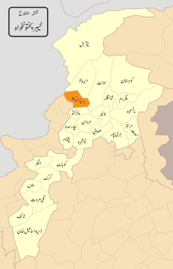
Lower Dir (Pashto: لر دیر, Urdu: دیر زیریں) is one of the 26[3]districts in the Khyber Pakhtunkhwa province of Pakistan. Timergara city is the district headquarters and largest city, while the second largest city is Chakdara. It is a bordering on one side with Bajaur and on the other side with Swat valley and district Malakand with upper part extending Dir Upper connecting Chitral Valley on Northern side.
At the time of independence, Dir was a princely state ruled by Nawab Shah Jehan Khan. It was merged in Pakistan in 1969 and later on declared a
district in 1970. The district was formed in 1996, when the district of Dir was divided into Upper Dir and Lower Dir. The District borders with Swat District on its East, Afghanistan on its West, Upper Dir and Chitral on its North & north-west respectively and Malakand and Bajaur Agency on its South.
Contents
1 Administration
1.1 National Assembly
1.2 Provincial Assembly
2 Notable people
3 See also
4 References
5 External links
Administration
The district is administratively subdivided into seven tehsils, Adenzai, Timergara, Balambat, Khall, Munda, Samar Bagh and Lal Qila Maidan, which contain a total of 41 Union Councils.[4] In Lower Dir, there are 7 tehsils:
| Tehsil | Union councils |
|---|---|
| Adenzai | Asbanr, Badwan, Chakdara, Khadagzai,Tazagram, Khanpur, Kotigram, Ouch |
| Balambat | Balambat, Hayaserai, Lajbook, Munjai, Koto, Rabat |
| Khall | Khall-I, Khall-II, Toormang-I, Toormang-II, Sultankhel (Payeen Dara) |
| Lal Qilla | Bishgram, Lal Qilla, Gall Maidan, Kotkai (Maidan), Zaimdara, |
| Munda | Khazana, Mia Kalai, Munda, |
| Samarbagh | Darangai, Kambat, Mayar, Maskini, Sadbar Kali, Samar Bagh |
| Timergara | Bagh Dush Khel, Bandagai, Khungai, Malak Abad Ghara, Noora Khel, Shahi Khel Ziarat Talash, Timergara (Urban) |
National Assembly
This district is represented by one elected MNA (Member of National Assembly) in Pakistan National Assembly. Its constituency is NA-34.[5]
| Member of National Assembly | Party Affiliation | Year |
|---|---|---|
| Qazi Hussain Ahmad | Muttahida Majlis-e-Amal | 2002 |
| Maulana Ahmad Ghafoor Ghawas | Muttahida Majlis-e-Amal | 2003 |
| Malak Azmat Khan | Pakistan Peoples Party | 2008 |
| Shahib Zada Muhammad Yaqub | Jamaat-e-Islami Pakistan | 2013 |
Qazi Hussain Ahmad won the general elections in 2002 but he left the seat as he had also won from his native constituency. Therefore, in January 2003 bye-elections were held.
Provincial Assembly
The district is represented by four elected MPAs in the provincial assembly who represent the following constituencies, after shifting of three union council from the Upper Dir to Lower Dir the provincial constituency of upper Dir, PF-93 now consists of UCs Khall, Toor Mang and Akha Gram of Lower Dir :[6]
- PK-94 (Lower Dir-I)
- PK-95 (Lower Dir-II)
- PK-96 (Lower Dir-III)
- PK-97 (Lower Dir-IV)
Notable people
Siraj ul Haq, Emir of Jamaat-e-Islami Pakistan
Hafiz Ibraheem
A famous educationist working in education department, KP as Director.
Malak Azmat
Remained Member of the parliament..
Nawabzada Mehmood Zeb
The ex-Minister and member of parliament.
Jan Alam Khan Yousafzai
Famous Town planner and owner of Paradise city, Noshera, KP
Ahmad Hassan Khan
The ex-deputy speaker National Assembly Pakistan.
Dr Shuaib
Famous doctor of Dir Lower served in health department.
Sufi Muhammad
Founder of Tehrek-e-Nifaz-e-Shriat-e-Muhammadi-TNSM Pakistan.
See also
- Constituency NA-34
- Education in Lower Dir District
- Upper Dir District
References
^ "DISTRICT AND TEHSIL LEVEL POPULATION SUMMARY WITH REGION BREAKUP: KHYBER PAKHTUNKHWA" (PDF). Pakistan Bureau of Statistics. 2018-01-03. Retrieved 2018-04-23..mw-parser-output cite.citation{font-style:inherit}.mw-parser-output q{quotes:"""""""'""'"}.mw-parser-output code.cs1-code{color:inherit;background:inherit;border:inherit;padding:inherit}.mw-parser-output .cs1-lock-free a{background:url("//upload.wikimedia.org/wikipedia/commons/thumb/6/65/Lock-green.svg/9px-Lock-green.svg.png")no-repeat;background-position:right .1em center}.mw-parser-output .cs1-lock-limited a,.mw-parser-output .cs1-lock-registration a{background:url("//upload.wikimedia.org/wikipedia/commons/thumb/d/d6/Lock-gray-alt-2.svg/9px-Lock-gray-alt-2.svg.png")no-repeat;background-position:right .1em center}.mw-parser-output .cs1-lock-subscription a{background:url("//upload.wikimedia.org/wikipedia/commons/thumb/a/aa/Lock-red-alt-2.svg/9px-Lock-red-alt-2.svg.png")no-repeat;background-position:right .1em center}.mw-parser-output .cs1-subscription,.mw-parser-output .cs1-registration{color:#555}.mw-parser-output .cs1-subscription span,.mw-parser-output .cs1-registration span{border-bottom:1px dotted;cursor:help}.mw-parser-output .cs1-hidden-error{display:none;font-size:100%}.mw-parser-output .cs1-visible-error{font-size:100%}.mw-parser-output .cs1-subscription,.mw-parser-output .cs1-registration,.mw-parser-output .cs1-format{font-size:95%}.mw-parser-output .cs1-kern-left,.mw-parser-output .cs1-kern-wl-left{padding-left:0.2em}.mw-parser-output .cs1-kern-right,.mw-parser-output .cs1-kern-wl-right{padding-right:0.2em}
^ 1998 District Census report of Lower Dir. Census publication. 31. Islamabad: Population Census Organization, Statistics Division, Government of Pakistan. 1999.
^ Report, Bureau (16 January 2014). "KP govt creates new Kohistan district". dawn.com.
^ "Tehsils & Unions in the District of Lower Dir – Government of Pakistan". nrb.gov.pk.
^ "Archived copy". Archived from the original on 2015-11-10. Retrieved 2015-11-06.CS1 maint: Archived copy as title (link)
^ Constituencies and MPAs – Website of the Provincial Assembly of the Khyber-Pakhtunkhwa Archived 2008-04-28 at the Wayback Machine.
External links
- Khyber-Pakhtunkhwa Government website section on Lower Dir
Districts of Khyber Pakhtunkhwa | ||
|---|---|---|
Provincial capital: Peshawar | ||
| Divisions | Districts |  |
| Bannu |
| |
| Dera Ismail Khan |
| |
| Hazara |
| |
| Kohat |
| |
| Malakand |
| |
| Mardan |
| |
| Peshawar |
| |
Administrative divisions of Lower Dir District | ||
|---|---|---|
| Tehsils | Union Councils | |
| Adenzai |
| |
| Balambat |
| |
| Lal Qilla |
| |
| Munda |
| |
| Samar Bagh |
| |
| Timergara |
| |
Coordinates: 34°51′N 71°51′E / 34.850°N 71.850°E / 34.850; 71.850


