Huahine
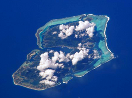 NASA picture of Huahine viewed from the north | |
 Huahine | |
| Geography | |
|---|---|
| Location | Pacific Ocean |
| Coordinates | 16°44′S 151°0′W / 16.733°S 151.000°W / -16.733; -151.000 |
| Archipelago | Society Islands |
| Area | 77.6 km2 (30.0 sq mi) |
| Length | 16 km (9.9 mi) |
| Width | 13 km (8.1 mi) |
| Highest elevation | 699 m (2,293 ft) |
| Highest point | Mount Turi |
| Administration | |
France | |
| Overseas collectivity | French Polynesia |
| Administrative subdivision | Leeward Islands |
| Commune | Huahine |
| Demographics | |
| Population | 6,303[1] (2012) |
| Pop. density | 84 /km2 (218 /sq mi) |
Huahine | ||
|---|---|---|
Commune | ||
| ||
 | ||
Location of Huahine | ||
| Coordinates: 16°44′S 151°00′W / 16.73°S 151.0°W / -16.73; -151.0Coordinates: 16°44′S 151°00′W / 16.73°S 151.0°W / -16.73; -151.0 | ||
| Country | France | |
| Overseas collectivity | French Polynesia | |
| Government | ||
| • Mayor .mw-parser-output .nobold{font-weight:normal} (2014 - 2020) | Marcelin Lisan | |
| Area | 80 km2 (30 sq mi) | |
| Population (2012)1 | 6,303 | |
| • Density | 79/km2 (200/sq mi) | |
INSEE/Postal code | 98724 /98731 | |
1Population without double counting: residents of multiple communes (e.g., students and military personnel) only counted once. | ||

Huahine is an island located among the Society Islands, in French Polynesia, an overseas territory of France in the Pacific Ocean. It is part of the Leeward Islands group (Îles sous le Vent). The island has a population of about 6,300.
Contents
1 Geography
2 History
3 Administration
4 Tourist attraction
5 See also
6 References
7 External links
Geography
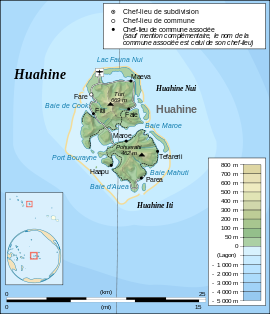
Huahine measures 16 km (10 mi) in length, with a maximum width of 13 km (8 mi). It is made up of two main islands surrounded by a fringing coral reef with several islets, or motu. Huahine Nui (Big Huahine) lies to the north and Huahine Iti (Little Huahine) to the south. The two islands are separated by a few hundred yards of water and joined by a sandspit at low tide. A small bridge was built to connect Huahine Nui and Huahine Iti.
In the northwest of Huahine Nui lies a 375 hectares (926.65 acres) brackish lake known as Lac Fauna Nui (Lac Maeva). This lake is all that remains of the ancient atoll lagoon. Air transportation is available via Huahine airport, located on the northern shore of Huahine Nui.
History
Captain James Cook arrived in Fare Harbour on 16 July 1769, with Tupaia navigating HMS Endeavour. They met with leading chief Ori (Mato). Cook returned on 3 September 1773 and met with Ori's son Teri'itaria, the new ari'i rahi of the island.[2]
Administration
Huahine emblem
Administratively Huahine is a commune (municipality) part of the administrative subdivision of the Leeward Islands. Huahine consists of the following associated communes:
- Faie
- Fare
- Fitii
- Haapu
- Maeva
- Maroe
- Parea
- Tefarerii
The administrative centre of the commune is the settlement of Fare, on Huahine Nui.
Tourist attraction
One of the famous[citation needed] attractions on Huahine is a bridge that crosses over a stream with 0.9 m - 1.8 m long freshwater eels. These eels are deemed sacred by the locals, by local mythology. While viewing these slithering creatures, tourists can buy a can of mackerel and feed the eels. The Fa'ahia archaeological site in the north of the island has revealed subfossil remains of several species of extinct birds exterminated by the earliest Polynesian colonists of the island.

Fare, Huahine: After-school play is interrupted by the catch and release of a stingray.
See also
| Wikimedia Commons has media related to Huahine. |
- List of monarchs of Huahine
References
^ "Population". Institut de la statistique de la Polynésie française (in French). Retrieved 11 January 2015..mw-parser-output cite.citation{font-style:inherit}.mw-parser-output q{quotes:"""""""'""'"}.mw-parser-output code.cs1-code{color:inherit;background:inherit;border:inherit;padding:inherit}.mw-parser-output .cs1-lock-free a{background:url("//upload.wikimedia.org/wikipedia/commons/thumb/6/65/Lock-green.svg/9px-Lock-green.svg.png")no-repeat;background-position:right .1em center}.mw-parser-output .cs1-lock-limited a,.mw-parser-output .cs1-lock-registration a{background:url("//upload.wikimedia.org/wikipedia/commons/thumb/d/d6/Lock-gray-alt-2.svg/9px-Lock-gray-alt-2.svg.png")no-repeat;background-position:right .1em center}.mw-parser-output .cs1-lock-subscription a{background:url("//upload.wikimedia.org/wikipedia/commons/thumb/a/aa/Lock-red-alt-2.svg/9px-Lock-red-alt-2.svg.png")no-repeat;background-position:right .1em center}.mw-parser-output .cs1-subscription,.mw-parser-output .cs1-registration{color:#555}.mw-parser-output .cs1-subscription span,.mw-parser-output .cs1-registration span{border-bottom:1px dotted;cursor:help}.mw-parser-output .cs1-hidden-error{display:none;font-size:100%}.mw-parser-output .cs1-visible-error{font-size:100%}.mw-parser-output .cs1-subscription,.mw-parser-output .cs1-registration,.mw-parser-output .cs1-format{font-size:95%}.mw-parser-output .cs1-kern-left,.mw-parser-output .cs1-kern-wl-left{padding-left:0.2em}.mw-parser-output .cs1-kern-right,.mw-parser-output .cs1-kern-wl-right{padding-right:0.2em}
^ Salmond, Anne (2010). Aphrodite's Island. Berkeley: University of California Press. pp. 205–209, 281, 314–318. ISBN 9780520261143.
External links
- Tahiti Tourism Board website
- Tourism portal on Huahine
- Free travel guide - Bilingual french english - 2016-2017
Society Islands of French Polynesia | |||
|---|---|---|---|
| |||
| |||
| |||


