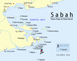
Kapalai (Malay: Pulau Kapalai) is an island in Tawau Division, Sabah, Malaysia, known for its scuba resorts.
The island of Kapalai, just 15 kilometres off Sipadan, was a beautiful island two hundred years ago, but now remains as only a sand bar. Erosion has reduced the island to sea level and the village now sits on the edge of the extensive Ligitan Reefs. All of the buildings rest on stilts resting on the underwater reef. There is only one private resort on the island, with the rest of the island uninhabited.
Contents
1Location
2Transportation
3Gallery
4See also
5References
6External links
Location
Kapalai is situated a couple of hours from the east coast of Borneo. Though the island is a relatively remote location to reach, there are daily flights from Kota Kinabalu, less than a one-hour flight from Tawau.
Transportation
As Kapalai Island is located off the east coast of Sabah / Borneo, Malaysia's easternmost state, direct flights are available to Tawau and Kota Kinabalu on Sabah from Kuala Lumpur on peninsular Malaysia and Singapore. The closest airport to Kapalai is Tawau, located approximately one hour from Semporna's jetty by minivan. Semporna's jetty serves as the speedboat departure point for Kapalai and the neighboring Sipadan Island and Mabul Island.
Kapalai Island is located to the northeast of Sipadan Island. Many tour operators provide roundtrip transfers from Tawau Airport to Semporna and onward to Kapalai Island.
Gallery
The island beach
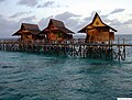
Accommodation in the island
See also
List of islands of Malaysia
References
External links
Sipadan-Kapalai Resort official website
Kapalai dive sites
ICJ Press Release
Photos of Kapalai Island
v
t
e
Islands of Sabah
Adal
Ampak-Ampak
Bai
Baik
Bait
Bakau-Bakau
Bakubang
Balak
Balambangan
Balangkasan
Balundangan Kecil
Balungang Besar
Balusuan
Bangan-Bangan
Banggi
Bankawan
Bangkuruan
Batawan
Batik
Batik Kulambu
Batu Laya-Laya
Berhala
Bilangan
Billean
Bingkulan
Bisa
Bodgaya
Bohayan
Boheydulang
Bonting
Bum Bum
Bush
Buwaning
Daisy
Danawan
Daunan
Delconte
Dewa
Dinawan
Di Tg. Batai
Di Tg. Pendaras
Engot
Evans
Gaya
Gatahan
Guhuan Utara
Gulisan
Gusong
Gusungan
Hutan Rimba
Jambongan
Kabili
Kahamkamman
Kalampunian
Kalampunian Besar
Kalampunian Damit
Kalangaan
Kalapuan
Kalumpang
Kalungan
Kalung Kalungan
Kanawi
Kaniogan
Kapalai
Kawan
Kelautan
Keramuk
Keremat
Kukuban
Laila
Lakatan
Landayang
Lankayan
Langaan
Lambidan
Larapan
Latoan
Leonan
Libaran
Ligitan
Lihak-Lihak
Lihiman
Limau Limauan
Linkabo
Lingisan
Little Bakkungaan
Lungisan
Lubukan
Mabahok
Mabul
Maganting
Maiga
Majinkil
Malawali
Maliangin Besar
Maliangin Kecil
Malundangan
Mamutik
Mandag-Mandag
Mandidarah
Mangkalai Darat
Mangkalai Laut
Mantabuan
Mantanani
Manukan
Mataking
Mataking Kecil
Mata Pahi
Mati
Menampilek
Mengalum
Merigi
Modom
Montokud
Musa
Nunuyan Darat
Nunuyan Laut
Nusa Kuya
Nusa Tengah
Omadal
Pababag
Pagassan
Pakil
Palak
Pandan-Pandan
Pandanan
Pandawan
Panimbawan
Panukaran
Papahan
Pasir
Patanunam
Peduk
Penampangan
Plompong
Pom Pom
Puno Puno
Puru Puru
Sabangkat
Saddle
Saga
Sakar
Salakan
Sand
Sandy
Sangai
Sapi
Sarangga
Sebangkat
Sebatik
Sedam
Selangan
Selingan
Sepanggar
Si Amil
Sibuon
Sikarindingan
Silawa
Silogong
Silumpat
Silungun
Simandalan
Simial
Sinamgil
Sinjataan
Sipadan
Sipanggau
Sipindung
Sisipan
Straggler
Sulug
Sulok
Sungor
Tabawan
Tabilian
Tabun
Tagabua
Tagujawan
Tambisan
Tambulian
Tango
Tanjung
Tanjung Tiga Papan
Tatagan-Tatagan
Tegaipil
Tetagan
Torongohok
Terumbu Eberett
Tetabuan
Tibakan
Tiga
Tigabu
Tigowis
Tikus
Timba Timba
Timbang
Timbun Mata
Timur
Tiong Kecil
Tree Rock
Udar Kecil
Udar Besar
Usukan
Source: List of islands in Sabah (Page 53/61)
This Sabah location article is a stub. You can help Wikipedia by expanding it.
Subprefecture and commune in Nouvelle-Aquitaine, France Bressuire Subprefecture and commune Chateau de Bressuire and the Eglise Notre-Dame Coat of arms Location of Bressuire Bressuire Show map of France Bressuire Show map of Nouvelle-Aquitaine Coordinates: 46°50′27″N 0°29′14″W / 46.8408°N 0.4872°W / 46.8408; -0.4872 Coordinates: 46°50′27″N 0°29′14″W / 46.8408°N 0.4872°W / 46.8408; -0.4872 Country France Region Nouvelle-Aquitaine Department Deux-Sèvres Arrondissement Bressuire Canton Bressuire Government • Mayor .mw-parser-output .nobold{font-weight:normal} (2014–20) Jean Michel Bernier Area 1 180.59 km 2 (69.73 sq mi) Population (2014) 2 19,300 • Density 110/km 2 (280/sq mi) Time zone UTC+01:00 (CET) • Summer (DST) UTC+02:00 (CEST) INSEE/Postal code 79049 /79300 Elevation 98–236 m (322–774 ft) (avg. 173 m or 568 ft) 1 French Land Register data, which exclude...
Vorschmack Ukrainian Jewish-style vorschmack served on rye bread Course Hors d'oeuvre Region or state Eastern Europe Associated national cuisine Ashkenazi Jewish, Finnish, German, Ukrainian, Polish, Russian Main ingredients Ground meat and/or fish Cookbook: Vorschmack Media: Vorschmack Vorschmack or forshmak (Yiddish: פֿאָרשמאַק , from archaic German Vorschmack , "foretaste" [1] or "appetizer" [2] ) is an originally East European dish made of salty minced fish or meat. Different variants of this dish are especially common in Ashkenazi Jewish and Finnish cuisine. Some varieties are also known in Russian and Polish cuisine. Contents 1 In Jewish cuisine 2 In Russian cuisine 3 In Polish cuisine 4 In Finnish cuisine 5 See also 6 References In Jewish cuisine According to Gil Marks, the German name points to the possible Germanic origin of this dish. [1] William Pokhlyobkin descr...
For other uses, see Quarantine (disambiguation). Signal flag "Lima" called the "Yellow Jack" which when flown in harbor means ship is under quarantine. A simple yellow flag (also called the "Yellow Jack") had historically been used to signal quarantine (it stands for Q among signal flags), but now indicates the opposite, as a signal of a ship free of disease that requests boarding and inspection. A quarantine is used to separate and restrict the movement of people; it is 'a restraint upon the activities or communication of persons or the transport of goods designed to prevent the spread of disease or pests', for a certain period of time. [1] This is often used in connection to disease and illness, such as those who may possibly have been exposed to a communicable disease. [2] The term is often erroneously used to mean medical isolation, which is "to separate ill persons who have a communicable disease from those who are healthy...