Bitburg-Prüm
Bitburg-Prüm | ||
|---|---|---|
District | ||
| ||
 | ||
| Country | Germany | |
| State | Rhineland-Palatinate | |
| Capital | Bitburg | |
| Area | ||
| • Total | 1,626.15 km2 (627.86 sq mi) | |
| Population (31 December 2017)[1] | ||
| • Total | 98,213 | |
| • Density | 60/km2 (160/sq mi) | |
| Time zone | UTC+01:00 (CET) | |
| • Summer (DST) | UTC+02:00 (CEST) | |
| Vehicle registration | BIT, PRÜ | |
| Website | bitburg-pruem.de | |
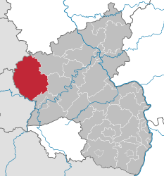
The Eifelkreis Bitburg-Prüm is a district in Rhineland-Palatinate, Germany. It is bounded by (from the west and clockwise) Luxembourg, Belgium and the districts of Euskirchen, Vulkaneifel, Bernkastel-Wittlich and Trier-Saarburg.
Contents
1 History
2 Geography
3 Coat of arms
4 Towns and municipalities
5 References
6 External links
History
There are three different historical regions: the abbey and the city of Prüm have been directly subordinate to the Holy Roman Emperor in medieval times; later the free city became the principality of Prüm, occupying large portions in the north.
The southwest including the town of Bitburg was a part of Luxemburg from the 10th to the 15th century. Later it was a part of the Seventeen Provinces and hence under Spanish and then Austrian rule. After the Napoleonic Wars the region was handed over to Prussia.
The eastern parts of the district, including the town of Kyllburg, were part of the Prince-bishopric of Trier.
When Prussia gained all these regions about 1815, it established the three districts of Bitburg, Prüm and Trier. In 1970 the districts of Bitburg and Prüm were merged with parts of the former district of Trier in order to form the present district.
On 1 January 2007 the full name of the district was changed to be Eifelkreis Bitburg-Prüm instead of Landkreis.
Geography
The district covers the sparsely populated southwestern part of the Eifel Mountains. The portions along the western borders are occupied by a common German-Belgian nature park and a German-Luxembourgian nature park. A great number of rivers rise from the Schneifel in the northwest and from the Kyllwald in the east, and runs southward to the Sauer River (French: Sûre), which is an affluent of the Moselle.
Coat of arms
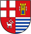 | The coat of arms displays:
|
Towns and municipalities
Verband-free town |
|---|
|
Verbandsgemeinden | |||
|---|---|---|---|
1. Arzfeld | |||
|
|
|
|
2. Bitburger Land [seat: Bitburg] | |||
|
|
|
|
3. Südeifel | |||
|
|
|
|
4. Prüm | |||
|
|
|
|
5. Speicher | |||
|
|
| |
1seat of the Verbandsgemeinde; 2town | |||
References
^ "Bevölkerungsstand 2017 - Gemeindeebene". Statistisches Landesamt Rheinland-Pfalz (in German). 2018..mw-parser-output cite.citation{font-style:inherit}.mw-parser-output .citation q{quotes:"""""""'""'"}.mw-parser-output .citation .cs1-lock-free a{background:url("//upload.wikimedia.org/wikipedia/commons/thumb/6/65/Lock-green.svg/9px-Lock-green.svg.png")no-repeat;background-position:right .1em center}.mw-parser-output .citation .cs1-lock-limited a,.mw-parser-output .citation .cs1-lock-registration a{background:url("//upload.wikimedia.org/wikipedia/commons/thumb/d/d6/Lock-gray-alt-2.svg/9px-Lock-gray-alt-2.svg.png")no-repeat;background-position:right .1em center}.mw-parser-output .citation .cs1-lock-subscription a{background:url("//upload.wikimedia.org/wikipedia/commons/thumb/a/aa/Lock-red-alt-2.svg/9px-Lock-red-alt-2.svg.png")no-repeat;background-position:right .1em center}.mw-parser-output .cs1-subscription,.mw-parser-output .cs1-registration{color:#555}.mw-parser-output .cs1-subscription span,.mw-parser-output .cs1-registration span{border-bottom:1px dotted;cursor:help}.mw-parser-output .cs1-ws-icon a{background:url("//upload.wikimedia.org/wikipedia/commons/thumb/4/4c/Wikisource-logo.svg/12px-Wikisource-logo.svg.png")no-repeat;background-position:right .1em center}.mw-parser-output code.cs1-code{color:inherit;background:inherit;border:inherit;padding:inherit}.mw-parser-output .cs1-hidden-error{display:none;font-size:100%}.mw-parser-output .cs1-visible-error{font-size:100%}.mw-parser-output .cs1-maint{display:none;color:#33aa33;margin-left:0.3em}.mw-parser-output .cs1-subscription,.mw-parser-output .cs1-registration,.mw-parser-output .cs1-format{font-size:95%}.mw-parser-output .cs1-kern-left,.mw-parser-output .cs1-kern-wl-left{padding-left:0.2em}.mw-parser-output .cs1-kern-right,.mw-parser-output .cs1-kern-wl-right{padding-right:0.2em}
External links
| Wikimedia Commons has media related to Eifelkreis Bitburg-Prüm. |
Official website (German)
German-Belgian Nature Park Hohes Venn / Eifel (German, French)
German-Luxembourgian Nature Park Southern Eifel (German, English, French, Dutch)
| Urban districts |
|
|---|---|
| Rural districts |
|
Towns and municipalities in Bitburg-Prüm | ||
|---|---|---|
| ||
Coordinates: 50°00′N 6°25′E / 50.0°N 6.42°E / 50.0; 6.42
Authority control |
|
|---|


