Northern Cheyenne Indian Reservation
Northern Cheyenne Tsėhéstáno | |
|---|---|
Reservation | |
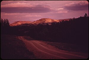 Hills and forests of the Northern Cheyenne | |
 Flag | |
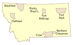 Indian Reservations in Montana | |
| Country | United States |
| States | Montana, South Dakota |
| Established | 1884 |
| Government | |
| • Governing body | Tribal council |
| • Tribal president | Llevando Fisher[1] |
| Population (2013) | |
| • Total | 4,939 |
| Time zone | UTC-7 (MST) |
| • Summer (DST) | UTC-6 (MDT) |
The Northern Cheyenne Indian Reservation (Cheyenne: Tsėhéstáno; formerly named the Tongue River) is home of the federally recognized Northern Cheyenne tribe. Located in southeastern Montana, the reservation is approximately 690 square miles (1,800 km2) in size and home to approximately 5,000 Cheyenne people. The tribal and government headquarters are located in Lame Deer, also the home of the annual Northern Cheyenne pow wow.
The reservation is bounded on the east by the Tongue River and on the west by the Crow Reservation. There are small parcels of non-contiguous off-reservation trust lands in Meade County, South Dakota, northeast of the city of Sturgis. Its timbered ridges that extend into northwestern South Dakota are part of Custer National Forest and it is approximately 40 miles (64 km) east of the site of the 1876 Battle of the Little Bighorn.
According to tribal enrollment figures as of March 2013, there were approximately 10,050 enrolled tribal members, of which about 4,939 were residing on the reservation,[2][incomplete short citation] with approximately 91% of the population Native American (full or part blood quantum) and 72.8% identifying as Cheyenne. Slightly more than a quarter of the population five years or older spoke a language other than English.[2] Members of the Crow Nation also live on the reservation.
Contents
1 Demographics
2 Communities and neighborhoods
3 Education
4 Footnotes
5 Sources
6 External links
Demographics
Traditional Cheyenne spiritual culture, like most traditional Indigenous spiritual ways, values the peoples' connection to their landbase, and sees the land itself, as well as special sites like Bear Butte, as sacred. Numerous Cheyenne work as foresters and fire fighters. This spiritual perspective is evident in traditional communities like Lame Deer and Birney and when the 2006 vote on development coal and coalbed methane on the reservation split along modernist vs traditional lines.[3][incomplete short citation]
A historical buffalo jump, burial sites of Cheyenne chiefs and spiritual leaders, the site of Custer's last camp before the Battle of the Little Bighorn, the Cheyenne Indian Museum, Ten Bears Gallery, St. Labre Indian School, and the Ashland Powwow are sites of special interest in the Ashland area.
The Northern Cheyenne are related to the Southern Cheyenne, who are located in Oklahoma. Following the Black Hills War and earlier conflicts in Colorado (see Sand Creek Massacre and Washita Massacre), the Northern Cheyenne were forcibly moved to Oklahoma and restricted to lands of their southern relatives. Unable to acclimate swiftly to the heat of western Oklahoma (Indian Territory at the time), having to grow their food instead of hunting or gathering as were their ways, and the brutal conditions in the barracks where they were held, the northerners quickly began dying. In desperation, a small band left the reservation and headed north in 1878, an odyssey that came to be known as the Northern Cheyenne Exodus.
The Northern Cheyenne briefly settled around Fort Keogh (Miles City, Montana). In the early 1880s, many families began to migrate south to the Tongue River watershed area and established homesteads in the northern edge of the Powder River Basin, which they considered their natural home. The Northern Cheyenne were allies of the Lakota in the Black Hills War of 1876–1877.
The United States government established the Tongue River Indian Reservation, which consisted of 371,200 acres (1,502 km2) of land, under the executive order given by President Chester A. Arthur on November 16, 1884 The boundaries originally did not include the Cheyenne who had homesteaded further east near the Tongue River, therefore those people who had were helped by the St. Labre Catholic Mission. This changed though when on March 19, 1900, President William McKinley extended the reservation to the west bank of the Tongue River, for a total of 444,157 acres (1,797.44 km2). Those Cheyenne who had homesteaded east of the Tongue River were relocated to reservation lands west of the river.[4]
Communities and neighborhoods
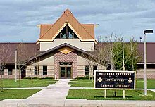
Northern Cheyenne headquarters
Lame Deer, Montana, with about 4,000 residents, of which 92% are American Indian, is the capital of the Northern Cheyenne nation. Chief Dull Knife College is located there. To the west is Muddy, Montana with about 600 residents, 94% American Indian, and further west Busby, Montana with about 700 residents, 90% American Indian. Busby was the site of the Tongue River Boarding School, opened in 1904. The school would later become quite active in basketball, with their team playing a winning game against the Harlem Globetrotters and winning a State championship in the 1950s. The Busby White River Cheyenne Mennonite Church is located in Busby.[5][incomplete short citation]
Ashland, Montana is to the east. In 1884 a Catholic boarding school, the St. Labre Indian School, was established there.[6] The 460 residents of Ashland are about 75% American Indian. They are also very active in basketball. When Busby became part of their district, they had notable rivalry basketball games in the late 1940s and on. Birney, Montana, population about 100, 86% Indian, is south of Lame Deer and Ashland. Part of Birney, "White Birney", lies south of the reservation.[7]
Colstrip, Montana is a neighboring industrial city devoted to coal mining and electrical generation. Located 20 miles north of the reservation, it has a population of about 2,300 residents, of which approximately 240, or 11%, are American Indians. It is also where some Cheyenne attend public school or live for work.[6]
Education
Chief Dull Knife College, originally named Dull Knife Memorial College, is an open admission Native American tribal community college and land grant institution. It is located on the reservation, in Lame Deer, and has a current enrollment of 141 students. On average, more than half of the graduates move on to four-year colleges. The college is accredited by the Northwest Commission on Colleges and Universities. It is member of the American Indian Higher Education Consortium and American Association of Community Colleges.[8][incomplete short citation]
The reservation is the recipient of a 2010 Promise Neighborhoods grant from the United States Department of Education, through the local Boys & Girls Clubs of America.[9][incomplete short citation]
Footnotes
^ Northern Cheyenne Tribe, Executive Branch
^ ab Northern Cheyenne Tribe website
^ "Northern Cheyenne voters split on resource development". billingsgazette.com. 7 November 2006. Retrieved 17 January 2011..mw-parser-output cite.citation{font-style:inherit}.mw-parser-output .citation q{quotes:"""""""'""'"}.mw-parser-output .citation .cs1-lock-free a{background:url("//upload.wikimedia.org/wikipedia/commons/thumb/6/65/Lock-green.svg/9px-Lock-green.svg.png")no-repeat;background-position:right .1em center}.mw-parser-output .citation .cs1-lock-limited a,.mw-parser-output .citation .cs1-lock-registration a{background:url("//upload.wikimedia.org/wikipedia/commons/thumb/d/d6/Lock-gray-alt-2.svg/9px-Lock-gray-alt-2.svg.png")no-repeat;background-position:right .1em center}.mw-parser-output .citation .cs1-lock-subscription a{background:url("//upload.wikimedia.org/wikipedia/commons/thumb/a/aa/Lock-red-alt-2.svg/9px-Lock-red-alt-2.svg.png")no-repeat;background-position:right .1em center}.mw-parser-output .cs1-subscription,.mw-parser-output .cs1-registration{color:#555}.mw-parser-output .cs1-subscription span,.mw-parser-output .cs1-registration span{border-bottom:1px dotted;cursor:help}.mw-parser-output .cs1-ws-icon a{background:url("//upload.wikimedia.org/wikipedia/commons/thumb/4/4c/Wikisource-logo.svg/12px-Wikisource-logo.svg.png")no-repeat;background-position:right .1em center}.mw-parser-output code.cs1-code{color:inherit;background:inherit;border:inherit;padding:inherit}.mw-parser-output .cs1-hidden-error{display:none;font-size:100%}.mw-parser-output .cs1-visible-error{font-size:100%}.mw-parser-output .cs1-maint{display:none;color:#33aa33;margin-left:0.3em}.mw-parser-output .cs1-subscription,.mw-parser-output .cs1-registration,.mw-parser-output .cs1-format{font-size:95%}.mw-parser-output .cs1-kern-left,.mw-parser-output .cs1-kern-wl-left{padding-left:0.2em}.mw-parser-output .cs1-kern-right,.mw-parser-output .cs1-kern-wl-right{padding-right:0.2em}
^ Page 30, We, the Northern Cheyenne People, accessed September 20, 2009
^ "Busby White River Cheyenne Mennonite Church", Global Anabaptist Mennonite Encyclopedia Online, accessed September 20, 2009
^ ab Page 91, We, the Northern Cheyenne People, accessed September 20, 2009
^ Page 48, We, the Northern Cheyenne People, accessed September 20, 2009
^ Dull Knife College website
^ US Department of Education Awards Promise Neighborhoods Planning Grants
Sources
- We, the Northern Cheyenne People
Northern Cheyenne Reservation and Off-Reservation Trust Land, Montana/South Dakota United States Census Bureau
External links
| Wikimedia Commons has media related to Northern Cheyenne. |
- Official website
"Bringing the Story of the Cheyenne People to the Children of Today", Montana state curriculum, 218-page pdf
| ||||||||||||||||||||||||||||||||||||||||||||||||||||||||||||||||||||||||


Coordinates: 45°31′56″N 106°40′48″W / 45.53222°N 106.68000°W / 45.53222; -106.68000


