Ione, Oregon
Ione, Oregon | |
|---|---|
City | |
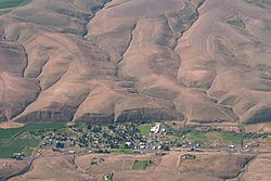 Aerial view of Ione | |
| Motto(s): Growing with Pride[1] | |
 Location in Oregon | |
| Coordinates: 45°30′3″N 119°49′28″W / 45.50083°N 119.82444°W / 45.50083; -119.82444Coordinates: 45°30′3″N 119°49′28″W / 45.50083°N 119.82444°W / 45.50083; -119.82444 | |
| Country | United States |
| State | Oregon |
| County | Morrow |
| Incorporated | 1903 |
| Government | |
| • Mayor | Linda LaRue[2] |
| Area [3] | |
| • Total | 0.65 sq mi (1.68 km2) |
| • Land | 0.65 sq mi (1.68 km2) |
| • Water | 0 sq mi (0 km2) |
| Elevation | 1,089 ft (332 m) |
| Population (2010)[4] | |
| • Total | 329 |
| • Estimate (2012[5]) | 330 |
| • Density | 506.2/sq mi (195.4/km2) |
| Time zone | UTC-8 (Pacific) |
| • Summer (DST) | UTC-7 (Pacific) |
| ZIP code | 97843 |
| Area code(s) | 458 and 541 |
| FIPS code | 41-36400[4] |
GNIS feature ID | 1123365[6] |
Ione is a city in Morrow County, Oregon, United States. The population was 329 at the 2010 census. It is part of the Pendleton–Hermiston Micropolitan Statistical Area.
Contents
1 Geography
1.1 Climate
2 History
3 Demographics
3.1 2010 census
3.2 2000 census
4 Economy and education
5 References
6 External links
Geography
Ione is at an elevation of 1,089 feet (332 m)[6] between the Columbia River to the north and the Blue Mountains to the southeast.[7] It is along Oregon Route 74, 18 miles (29 km) northwest of Heppner,[7] 27 miles (43 km) south of Interstate 84 (I-84), and 173 miles (278 km) east of Portland.[8]
Willow Creek flows through Ione, which is downstream of Heppner and Lexington and upstream of Arlington.[7] According to the United States Census Bureau, the city has a total area of 0.65 square miles (1.68 km2), all of it land.[3]
Route 74 forms part of the Blue Mountain Scenic Byway, a 130-mile (210 km) set of roads connecting I-84 along the Columbia River with the North Fork John Day River in the Blue Mountains. Part of the route follows the Willow Creek drainage through Ione.[9]
Climate
This region experiences warm (but not hot) and dry summers, with no average monthly temperatures above 71.6 °F (22.0 °C). According to the Köppen climate classification system, Ione has a warm-summer Mediterranean climate, Csb on climate maps.[10]
History
In 1883, landowner E. G. Sperry named the community Ione after Ione Arthur, a girl who was visiting the Sperrys with her family. Aaron Royse managed the first store in Ione, and he became the first postmaster when an Ione post office was established in 1884.[11]
Sheep ranching was important in the region during the days of early settlement by non-natives. It continues in the 21st century and has been joined by wheat farming and cattle ranching as significant uses of the land.[9]
Demographics
| Historical population | |||
|---|---|---|---|
| Census | Pop. | %± | |
| 1900 | 223 | — | |
| 1910 | 239 | 7.2% | |
| 1920 | 439 | 83.7% | |
| 1930 | 283 | −35.5% | |
| 1940 | 262 | −7.4% | |
| 1950 | 262 | 0.0% | |
| 1960 | 350 | 33.6% | |
| 1970 | 355 | 1.4% | |
| 1980 | 345 | −2.8% | |
| 1990 | 255 | −26.1% | |
| 2000 | 321 | 25.9% | |
| 2010 | 329 | 2.5% | |
| Est. 2016 | 333 | [12] | 1.2% |
| source:[4][13] | |||
2010 census
As of the census of 2010, there were 329 people, 132 households, and 90 families residing in the city. The population density was 506.2 inhabitants per square mile (195.4/km2). There were 154 housing units at an average density of 236.9 per square mile (91.5/km2). The racial makeup of the city was 86.6% White, 0.9% Native American, 0.6% Asian, 8.2% from other races, and 3.6% from two or more races. Hispanic or Latino of any race were 11.9% of the population.[4]
There were 132 households of which 34.8% had children under the age of 18 living with them, 61.4% were married couples living together, 3.0% had a female householder with no husband present, 3.8% had a male householder with no wife present, and 31.8% were non-families. 24.2% of all households were made up of individuals and 12.9% had someone living alone who was 65 years of age or older. The average household size was 2.49 and the average family size was 3.03.[4]
The median age in the city was 42.3 years. 24.6% of residents were under the age of 18; 8.9% were between the ages of 18 and 24; 19.4% were from 25 to 44; 32.5% were from 45 to 64; and 14.6% were 65 years of age or older. The gender makeup of the city was 52.0% male and 48.0% female.[4]
2000 census
As of the census of 2000, there were 321 people, 127 households, and 86 families residing in the city. The population density was 551.8 people per square mile (213.7/km2). There were 142 housing units at an average density of 244.1 per square mile (94.5/km2). The racial makeup of the city was 97.82% White, and 2.18% from two or more races. Hispanic or Latino of any race were 3.12% of the population.[4]
There were 127 households out of which 32.3% had children under the age of 18 living with them, 59.1% were married couples living together, 6.3% had a female householder with no husband present, and 31.5% were non-families. 29.1% of all households were made up of individuals and 10.2% had someone living alone who was 65 years of age or older. The average household size was 2.53 and the average family size was 3.09.[4]
In the city, the population was spread out with 28.3% under the age of 18, 5.6% from 18 to 24, 29.6% from 25 to 44, 20.6% from 45 to 64, and 15.9% who were 65 years of age or older. The median age was 38 years. For every 100 females, there were 112.6 males. For every 100 females age 18 and over, there were 111.0 males.[4]
The median income for a household in the city was $37,500, and the median income for a family was $43,750. Males had a median income of $32,143 versus $21,250 for females. The per capita income for the city was $14,531. About 5.8% of families and 6.2% of the population were below the poverty line, including 5.3% of those under age 18 and 9.7% of those age 65 or over.[4]
Economy and education
Ione Community Charter School, serving about 200 students in grades kindergarten through 12, is in Ione. Formerly part of the Morrow County School District, the school is in the Ione School District, with headquarters in Ione.[14]
As of 2002, the top employers for Ione were the Ione Community School and—all in Heppner—the Columbia Basin Electric Co-op, Miller & Sons Welding, and the Heppner Gazette-Times (a weekly newspaper).[8]
References
^ "City of Ione Strategic Plan" (PDF). Greater Eastern Oregon Development Commission. November 2009. Retrieved April 7, 2012..mw-parser-output cite.citation{font-style:inherit}.mw-parser-output .citation q{quotes:"""""""'""'"}.mw-parser-output .citation .cs1-lock-free a{background:url("//upload.wikimedia.org/wikipedia/commons/thumb/6/65/Lock-green.svg/9px-Lock-green.svg.png")no-repeat;background-position:right .1em center}.mw-parser-output .citation .cs1-lock-limited a,.mw-parser-output .citation .cs1-lock-registration a{background:url("//upload.wikimedia.org/wikipedia/commons/thumb/d/d6/Lock-gray-alt-2.svg/9px-Lock-gray-alt-2.svg.png")no-repeat;background-position:right .1em center}.mw-parser-output .citation .cs1-lock-subscription a{background:url("//upload.wikimedia.org/wikipedia/commons/thumb/a/aa/Lock-red-alt-2.svg/9px-Lock-red-alt-2.svg.png")no-repeat;background-position:right .1em center}.mw-parser-output .cs1-subscription,.mw-parser-output .cs1-registration{color:#555}.mw-parser-output .cs1-subscription span,.mw-parser-output .cs1-registration span{border-bottom:1px dotted;cursor:help}.mw-parser-output .cs1-ws-icon a{background:url("//upload.wikimedia.org/wikipedia/commons/thumb/4/4c/Wikisource-logo.svg/12px-Wikisource-logo.svg.png")no-repeat;background-position:right .1em center}.mw-parser-output code.cs1-code{color:inherit;background:inherit;border:inherit;padding:inherit}.mw-parser-output .cs1-hidden-error{display:none;font-size:100%}.mw-parser-output .cs1-visible-error{font-size:100%}.mw-parser-output .cs1-maint{display:none;color:#33aa33;margin-left:0.3em}.mw-parser-output .cs1-subscription,.mw-parser-output .cs1-registration,.mw-parser-output .cs1-format{font-size:95%}.mw-parser-output .cs1-kern-left,.mw-parser-output .cs1-kern-wl-left{padding-left:0.2em}.mw-parser-output .cs1-kern-right,.mw-parser-output .cs1-kern-wl-right{padding-right:0.2em}
^ "Incorporated Cities: Ione". Oregon Blue Book. Oregon Secretary of State. 2013. Retrieved July 15, 2013.
^ ab "U.S. Gazetteer: 2010, 2000, and 1990". United States Census Bureau. Retrieved July 15, 2013.
^ abcdefghij "American FactFinder". U.S. Census Bureau. Archived from the original on December 10, 2014. Retrieved July 15, 2013.
^ "Population Estimates". United States Census Bureau. Archived from the original on June 17, 2013. Retrieved June 2, 2013.
^ ab "Ione". Geographic Names Information System. United States Geological Survey. November 28, 1980. Retrieved July 15, 2013.
^ abc The 2013 Road Atlas. Chicago, Illinois: Rand McNally. pp. 84, 85. ISBN 978-052-80062-2-7.
^ ab "Ione Community Profile". Infrastructure Finance Authority. 2009. Retrieved July 15, 2013.
^ ab Ostertag, Rhonda (2004). Backroads of Oregon: Your Guide to Oregon's Most Scenic Backroad Adventures. Stillwater, Minnesota: Voyageur Press. pp. 105–06. ISBN 0-89658-081-4.
^ Climate Summary for Ione, Oregon
^ McArthur, Lewis A.; Lewis L. McArthur (2003) [1928]. Oregon Geographic Names (7th ed.). Portland, Oregon: Oregon Historical Society Press. p. 499. ISBN 0-87595-277-1.
^ "Population and Housing Unit Estimates". Retrieved June 9, 2017.
^ Moffatt, Riley Moore (1996). Population History of Western U.S. Cities and Towns, 1850–1990. Lanham, Maryland: Scarecrow Press. p. 211. ISBN 978-0-8108-3033-2.
^ "About Us". Ione School District. 2013. Retrieved July 17, 2013.
External links
Entry for Ione in the Oregon Blue Book
Municipalities and communities of Morrow County, Oregon, United States | ||
|---|---|---|
County seat: Heppner | ||
| Cities |
|  |
| Unincorporated communities |
| |
| Ghost town |
| |


