Ida-Viru County
Ida-Viru County | |||
|---|---|---|---|
County of Estonia | |||
 | |||
| |||
 | |||
| Country | Estonia | ||
| Capital | Jõhvi | ||
| Government | |||
| • Governor | Andres Noormägi[1] | ||
| Area | |||
| • Total | 3,364 km2 (1,299 sq mi) | ||
| Population (Jan 2017[2]) | |||
| • Total | 140,388 | ||
| • Rank | 3rd | ||
| • Density | 42/km2 (110/sq mi) | ||
Ethnicity | |||
| • Russians | 73.1% | ||
| • Estonians | 18.9% | ||
| • Ukrainians | 2.3% | ||
| • other | 5.7% | ||
| ISO 3166 code | EE-44 | ||
| Vehicle registration | I | ||
| Website | www.ida-virumaa.ee | ||


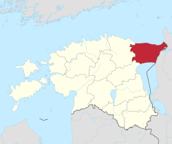
Ida-Viru County (Estonian: Ida-Viru maakond), or Ida-Virumaa, is one of 15 counties of Estonia. It is the most north-eastern part of the country. The county contains large deposits of oil shale - the main mineral mined in Estonia. As oil shale is used in thermal power plants, the earth in Ida-Viru contains most of Estonia's energy resources. The capital of the county is the town of Jõhvi which is administratively united with the Jõhvi Parish. In January 2016 Ida-Viru County had a population of 146,506 – constituting 12.6% of the total population in Estonia.[2]. It borders Lääne-Viru County in the west, Jõgeva County in the southwest and Russia (Leningrad Oblast) in the east.
Contents
1 History
2 County Government
3 Demographics
4 Municipalities
5 Landmarks
6 References
7 External links
History
During the latter part of the period of Soviet rule of Estonia, Ida-Virumaa was called Kohtla-Järve district, and its administrative capital was Kohtla-Järve.
County Government
The County Government (Estonian: Maavalitsus) is led by a governor (Estonian: maavanem), who is appointed by the country's government for a term of five years. The current[when?] governor of Ida-Viru county is Andres Noormägi.[1]
Demographics
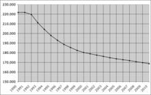
The population of Ida-Viru county declined from 221,807 in 1990 to 168,656 in 2010.
In January 2017, the population of Ida-Virumaa was 143,880, which makes it the third largest county in Estonia (after Harju and Tartu counties, which include the capital Tallinn and country's second-largest city Tartu). 44.6% of the population are men and 55.4% women.[2]
In the aftermath of World War II, Estonia was occupied by the Soviet Union and large swaths of Ida-Viru County underwent ethnic cleansing by the Soviet authorities. Estonians, who were forced out of the major population centers, including Narva, were replaced by colonists from Russia. As a result of mass migration from the Soviet Union, Ida-Viru County is now the only county in Estonia where ethnic Russians have largely replaced the indigenous Estonian population.
By ethnic origin, on 1 January 2017, 73.1% of the population were Russians, 18.9% were Estonians, 2.3% were Ukrainians, 2.1% were Belarusians and 0.9% were Finns.[2]
Municipalities
Ida-Virumaa County is subdivided into 8 municipalities, of which 4 are urban (Estonian: linnad — cities or towns) and 4 are rural (Estonian: vallad — parishes). There are 217 villages in Ida-Virumaa.

Municipalities of Ida-Viru County
| Rank | Municipality | Type | Population (2018)[3] | Area km2[3] | Density[3] |
|---|---|---|---|---|---|
| 1 | Alutaguse Parish | Rural | 4,929 | 1,465 | 3.4 |
| 2 | Jõhvi Parish | Rural | 11,645 | 124 | 93.9 |
| 3 | Kohtla-Järve | Urban | 35,395 | 39 | 907.6 |
| 4 | Lüganuse Parish | Rural | 8,942 | 599 | 14.9 |
| 5 | Narva | Urban | 58,610 | 85 | 689.5 |
| 6 | Narva-Jõesuu | Urban | 4,828 | 411 | 11.7 |
| 7 | Sillamäe | Urban | 13,406 | 11 | 1,218.7 |
| 8 | Toila Parish | Rural | 4,807 | 266 | 18.1 |
Landmarks

Pühtitsa Convent

Lake Uljaste
Ash hills in Ida-Viru County
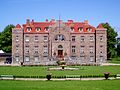
Kalvi manor house
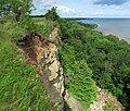
Aseri cliff

Avinurme church

Selisoo bog

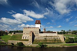
Hermann Castle

Mäetaguse manor house
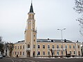
Sillamäe town hall


References
^ ab "Maavanem". Retrieved 24 September 2015..mw-parser-output cite.citation{font-style:inherit}.mw-parser-output .citation q{quotes:"""""""'""'"}.mw-parser-output .citation .cs1-lock-free a{background:url("//upload.wikimedia.org/wikipedia/commons/thumb/6/65/Lock-green.svg/9px-Lock-green.svg.png")no-repeat;background-position:right .1em center}.mw-parser-output .citation .cs1-lock-limited a,.mw-parser-output .citation .cs1-lock-registration a{background:url("//upload.wikimedia.org/wikipedia/commons/thumb/d/d6/Lock-gray-alt-2.svg/9px-Lock-gray-alt-2.svg.png")no-repeat;background-position:right .1em center}.mw-parser-output .citation .cs1-lock-subscription a{background:url("//upload.wikimedia.org/wikipedia/commons/thumb/a/aa/Lock-red-alt-2.svg/9px-Lock-red-alt-2.svg.png")no-repeat;background-position:right .1em center}.mw-parser-output .cs1-subscription,.mw-parser-output .cs1-registration{color:#555}.mw-parser-output .cs1-subscription span,.mw-parser-output .cs1-registration span{border-bottom:1px dotted;cursor:help}.mw-parser-output .cs1-ws-icon a{background:url("//upload.wikimedia.org/wikipedia/commons/thumb/4/4c/Wikisource-logo.svg/12px-Wikisource-logo.svg.png")no-repeat;background-position:right .1em center}.mw-parser-output code.cs1-code{color:inherit;background:inherit;border:inherit;padding:inherit}.mw-parser-output .cs1-hidden-error{display:none;font-size:100%}.mw-parser-output .cs1-visible-error{font-size:100%}.mw-parser-output .cs1-maint{display:none;color:#33aa33;margin-left:0.3em}.mw-parser-output .cs1-subscription,.mw-parser-output .cs1-registration,.mw-parser-output .cs1-format{font-size:95%}.mw-parser-output .cs1-kern-left,.mw-parser-output .cs1-kern-wl-left{padding-left:0.2em}.mw-parser-output .cs1-kern-right,.mw-parser-output .cs1-kern-wl-right{padding-right:0.2em}
^ abcd "Population by sex, ethnic nationality and County, 1 January". stat.ee. Statistics Estonia. 2010-04-19. Retrieved 2010-08-19.
^ abc "Elanike demograafiline jaotus maakonniti". Kohaliku omavalitsuse portaal. Retrieved 2 April 2018.
External links
Official website (in Estonian)
- Ida-Virumaa Tourism Portal
| Wikimedia Commons has media related to Ida-Viru County. |
Geographic locale | ||||||||||||||||||||||||
|---|---|---|---|---|---|---|---|---|---|---|---|---|---|---|---|---|---|---|---|---|---|---|---|---|
| ||||||||||||||||||||||||
Coordinates: 59°13′N 27°18′E / 59.217°N 27.300°E / 59.217; 27.300


