List of tributaries of the Danube
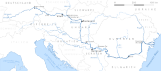
Map of most important tributaries of the Danube
This is a list of tributaries of the Danube by order of entrance.
The Danube is Europe's second-longest river. It starts in the Black Forest in Germany as two smaller rivers—the Brigach and the Breg—which join at Donaueschingen, and it is from here that it is known as the Danube, flowing generally eastwards for a distance of some 2,850 km (1,770 mi), passing through several Central and Eastern European capitals, before emptying into the Black Sea via the Danube Delta in Romania.
The Danube flows through—or forms a part of the borders of—ten countries: Germany, Austria, Slovakia, Hungary, Croatia, Serbia, Bulgaria, Romania, Moldova, and Ukraine; in addition, the drainage basin includes parts of nine more countries: Poland, Switzerland, Italy, Czech Republic, Slovenia, Bosnia and Herzegovina, Montenegro, Republic of Macedonia and Albania.
| River | Entering the Danube at | Distance from mouth (Sulina) (km) | Side of the entrance | Length (km) |
|---|---|---|---|---|
Iller | Ulm, Germany | right | 147 | |
Wörnitz | Donauwörth, Germany | left | 132 | |
Zusam | Donauwörth, Germany | right | 6 | |
Lech | Marxheim (near Donauwörth), Germany | right | 264 | |
Paar | near Vohburg, Germany | right | 134 | |
Abens | near Neustadt (Donau), Germany | right | ||
Altmühl | Kelheim, Germany | 2414.68 | left | 23 |
Hopfenbach | Kelheim, Germany | 2410.67 | right | |
Schwarze Laber | Schwalbennest | 2387.9 | left | |
Naab | Regensburg, Germany | 2385.3 | left | 165 |
Regen | Regensburg, Germany | 2379.24 | left | 165 |
Sulzbach | Donaustauf | 2367.5 | left | |
Otterbach | Donaustauf | 2367.6 | left | |
Pfatter | Pfatter | 2349.31 | right | |
Wiesent | 2346.43 | left | ||
Große Laaber | near Straubing, Germany | 2329.51 | right | |
Aiterach | Reibersdorf | 2214.0 | right | |
Kinsach | Reibersdorf | 2213.39 | left | |
Isar | near Deggendorf, Germany | 2281.71 | right | 286 |
Hengersberger Ohe | Winzer | 2264.21 | left | |
Angerbach | Hofkirchen | 2256.89 | right | |
Vils | Vilshofen, Germany | 2248.63 | right | |
Gaißa | Heining | 2233.85 | left | |
Ilz | Passau, Germany | 2225.43 | left | |
Inn | Passau, Germany | 2225.2 | right | 517 |
Satzbach | Löwmühle | 2221.3 | left | |
Kößelbach | Kernmühle | 2218.0 | right | |
Erlau | Erlau | 2215.15 | left | |
Dantelbach | Dantelbach | 2201.77 | left | |
Rannabach | Oberranna | 2196.04 | left | |
Kesselbach | Kager-Niederranna | 2194.55 | right | |
Kleine Mühl | Obermühl/Grafenau | 2177.85 | left | |
Große Mühl | Untermühl/Partenstein/Austria | 2168.0 | left | |
Große Rodl | Wilhering | 2144.83 | left | |
Bleicherbach | Wilhering | 2143.35 | left | |
Traun | near Linz, Austria | 2124.73 | right | 153 |
Ipfbach | Enghagen | 2116.98 | right | |
Gusen | Enghagen | 2113.6 | left | |
Enns | Mauthausen, Austria | 2111.828 | right | 254 |
Aist | Naarn im Machlande | 2108.5 | left | |
Isper | Isperdorf | 2065.7 | right | |
Ybbs | Ybbs an der Donau, Austria | 2057.1 | right | 13 |
Erlauf | Pöchlarn | 2046.3 | left | |
Pielach | Schallemmersdorf | 2034.35 | left | |
Aggsbach | Aggstein | 2027.17 | right | |
Endlingbach | Aggstein | 2026.97 | left | |
Spitzerbach | Spitz | 2019.58 | left | |
Fladnitzbach | near Palt (Krems an der Donau) | 2000.6 | right | |
Traisen | Altenwörth | 1979.1 | right | |
Perschling | Klein Schönbüchel | 1972.1 | right | |
Große Tulln | Tulln | 1965.27 | right | |
Schwechat | Upstream of Schönau | 1913.7 | right | |
Russbach | 1881.2 | left | ||
Morava | Devín, Slovakia | 1880.26 | left | 358 |
Vidrica | 1871.5 | left | ||
Leitha | near Mosonmagyaróvár, Hungary[1] | 1793.0 | right | 18 |
Rába | Győr, Hungary [2] | 1793.0 | right | 322 |
Conco | Upstream of Komarom | 1777.0 | right | |
Váh | Komárno, Slovakia | 1765.8 | left | 403 |
Hron | near Štúrovo, Slovakia | 1716.0 | left | 298 |
Ipel | near Szob, Hungary | 1708.2 | left | 232 |
Lepence | Lepence | 1697.0 | right | |
Benta | 1621.75 | right | ||
Sió | near Szekszárd, Hungary | 1497.15 | right | 121 (360)[3] |
Vajastorok | 1494.6 | left | ||
Drava | near Osijek, Croatia | 1382.5 | right | 725 |
Vuka | Vukovar, Croatia | 1333.1 | right | 114 |
Tisza | near Titel, Serbia | 1214.5 | left | 965 |
Sava | Belgrade, Serbia | 1170 | right | 990[4] |
Tamiš | near Pančevo, Serbia | 1154.2 | left | 359 |
Jezava | 1115.2 | right | ||
Velika Morava | near Smederevo, Serbia | 1104.5 | right | 185 (493, 550)[5] |
Mlava | near Kostolac, Serbia | 1091.6 | right | 158 |
Karaš | near Stara Palanka, Serbia | 1076.5 | left | 11 |
Nera | near Stara Palanka, Serbian-Romanian border | 1075.0 | left | 124 |
Ribiş River | Downstream of Baziaş | 1070.0 | left | |
Pârâul Ţiganilor | 1059.79 | left | ||
Râul Mic | 1058.8 | left | ||
Pek | Veliko Gradište, Serbia | 1057.1 | right | 129 |
Prva | Upstream of Moldova Veche | 1050.9 | left | |
Valea Mare River | Moldova Veche | left | ||
Baronul | Downstream of Moldova Veche | left | ||
Boşneag | 1045.3 | left | ||
Varad | Upstream of Coronini | 1042.4 | left | |
Sicolovăţ | 1039.4 | left | ||
Livadica | 1037.3 | right | ||
Alibeg | 1034.9 | left | ||
Liuborajdia | 1031.9 | left | ||
Cruşoviţa | 1029.6 | left | ||
Cezava | Cezava | 1026.8 | right | |
Caoniţa | 1026.65 | left | ||
Cameniţa | 1025.7 | left | ||
Turski Potok | 1025.3 | right | ||
Orevița | Liubcova | 1022.9 | left | |
Dobra | 1021.0 | right | ||
Zascoc | 1020.1 | left | ||
Zidinac | Zidinac | 1019.0 | right | |
Berzasca | Berzasca | 1017.8 | left | |
Kozica | right | |||
Suva | 1015.5 | left | ||
Cozla | Cozla | 1013,3 | left | |
Sirina | Downstream of Cozla | 1012.1 | left | |
Pesaca | 1009.4 | right | ||
Elişeva | 1007.3 | left | ||
Boljetinska | 1003.2 | right | ||
Saraoschi | left | |||
Starişte | 1000.9 | left | ||
Paolina | 999.5 | left | ||
Suşcava | 994.5 | left | ||
Ciuceavca | 993.4 | left | ||
Zlatica | 992.8 | right | ||
Porečka | 988.2 | right | 5 | |
Iuţi | 988 | left | ||
Tişoviţa | Tişoviţa | 982.6 | left | |
Reciţa | Downstream of Tişoviţa | 981.3 | left | |
Liubotina | 979.7 | left | ||
Plavişeviţa | 976.2 | left | ||
Ponicova | 972.8 | left | ||
Mraconia | 967.0 | left | ||
Costineţiu | 964.6 | left | ||
Suhodolu | 963.4 | left | ||
Mala | 961.4 | left | ||
Valea Satului | Upstream of Eșelnița | left | ||
Eșelnița | Eșelnița | 959.7 | left | |
Dâlboca | 957.7 | left | ||
Velika Kovila | 956.9 | right | ||
Groţca | 955.2 | left | ||
Cerna | 953.2 | left | 84 | |
Bahna | 949.8 | left | ||
Dzevrin | 949.2 | right | ||
Vodiţa | left | |||
Kasajna | 946.8 | right | ||
Jidoştiţa | left | |||
Kladusnica | 936.8 | right | ||
Dudaş | 936.6 | left | ||
Topolniţa | 927.8 | left | ||
Bistriţa | 920.6 | left | ||
Slatina | Slatina | 879 | right | |
Timok | Bulgarian-Serbian border | 845.65 | right | 203 |
Drincea | left | |||
Topolovetz | 784.1 | right | ||
Vojniska | 782.2 | right | ||
Vidbol | 780.2 | right | ||
Artchar | 768.5 | right | ||
Skomlia | 762.5 | right | ||
Lom | Lom, Bulgaria | 741,7 | right | 93 |
Sărăceaua | Cârna | left | ||
Desnăţui | Lake Bistreţu | left | ||
Tzibritza | 715.85 | right | ||
Nedeia | 697.6 | left | ||
Jiu | between the Bulgarian towns of Kozloduy and Oryahovo | 691.55 | left | 331 |
Ogosta | between the Jiu's mouth and Oryahovo, Bulgaria | 684.5 | right | 147 |
Jieţ | 681 | left | ||
Iskar River | Gigen, Pleven Province, Bulgaria | 637.0 | right | 368 |
Celei | Celei | 634.1 | left | |
Ursa | Gârcov | left | ||
Vit | Somovit, Bulgaria | 609.5 | right | 189 |
Olt | Turnu Măgurele, Romania | 604.0 | left | 709 |
Sâi | Turnu Măgurele | 600.6 | left | |
Osam | Nikopol, Bulgaria | 600.1 | right | 314 |
Călmățui | Suhaia | left | ||
Yantra | Svishtov, Bulgaria | 536.7 | right | 285 |
Vedea | Bujoru, Romania | left | 224 | |
Parapanca | Slobozia | left | ||
Rusenski Lom | Ruse, Bulgaria | 497.8 | right | 45 (196.9)[6] |
Argeş | Olteniţa, Romania | 430.0 | left | 327 |
Mostiştea | left | |||
Berza | Lake Gălăţui | left | ||
Almălău | Lake Bugeac | right | ||
Begena | Lake Bugeac | right | ||
Galiţa | Galiţa | right | ||
Canlia | Canlia | right | ||
Canaraua Fetei | Lake Oltina | right | ||
Jegălia | Jegălia | left | ||
Valea Mare | Lake Dunăreni | right | ||
Vederoasa | left | |||
Urluia | Upstream of Rasova | right | ||
Rasova | Rasova | right | ||
Peştera | Cochirleni | right | ||
Ţibrin | right | |||
Dunărea | Dunărea | right | ||
Calachioi | Capidava | left | ||
Chichirgeaua | Tichileşti | right | ||
Ialomiţa | Near Hârşova | left | 40 | |
Topolog | Saraiu | right | ||
Nămoleşti | Gârliciu | right | ||
Călmăţui | left | |||
Başburun | Ostrov | left | ||
Aiorman | Peceneaga | left | ||
Greci | left | |||
Cerna | Lake Cerna | right | ||
Valea Plopilor | Măcin Branch | right | ||
Jilila | Lake Jijila | right | ||
Siret | Galaţi, Romania | 155.05 | left | 726 |
Prut | near Reni, Ukraine | 134.144 | left | 953 |
Gârla Ciulineţul | Lake Crapina | left | ||
Luncaviţa | Luncaviţa | right |
See also
- International Commission for the Protection of the Danube River
Notes
.mw-parser-output .refbegin{font-size:90%;margin-bottom:0.5em}.mw-parser-output .refbegin-hanging-indents>ul{list-style-type:none;margin-left:0}.mw-parser-output .refbegin-hanging-indents>ul>li,.mw-parser-output .refbegin-hanging-indents>dl>dd{margin-left:0;padding-left:3.2em;text-indent:-3.2em;list-style:none}.mw-parser-output .refbegin-100{font-size:100%}
^ The Rába flows into the Mosoni-Duna, a branch of the Danube
^ The Rába flows into the Mosoni-Duna, a branch of the Danube
^ The Sió is 121 km long. As it flows out from the Balaton lake, measured from the source of the lake's longest tributary, the river Zala, it is 360 long.
^ The Sava is 945 km long, but as it originates from two shorter rivers, Sava Dolinka and Sava Bohinjka, with the longer headwater of Sava Dolinka it measures 990 km.
^ The Velika Morava is created by the confluence of the Južna Morava and the Zapadna Morava. The Velika Morava proper is 185 km long, but also counting its longer branch, Zapadna Morava, it is 493 km long. The most distant water source in the Morava watershed is the source of the river Ibar, the longest tributary of the Zapadna Morava, which gives the Ibar-Zapadna Morava-Velika Morava river system a length of 550 km.
^ The Rusenski Lom is formed by the confluence of the Beli Lom and the Cherni Lom. The Rusenski Lom proper is about 45 km long, but counting its longer branch, the Beli Lom, it is 196.9 km.
References
Mala Prosvetina Enciklopedija, Third edition (1985); Prosveta-Beograd; .mw-parser-output cite.citation{font-style:inherit}.mw-parser-output .citation q{quotes:"""""""'""'"}.mw-parser-output .citation .cs1-lock-free a{background:url("//upload.wikimedia.org/wikipedia/commons/thumb/6/65/Lock-green.svg/9px-Lock-green.svg.png")no-repeat;background-position:right .1em center}.mw-parser-output .citation .cs1-lock-limited a,.mw-parser-output .citation .cs1-lock-registration a{background:url("//upload.wikimedia.org/wikipedia/commons/thumb/d/d6/Lock-gray-alt-2.svg/9px-Lock-gray-alt-2.svg.png")no-repeat;background-position:right .1em center}.mw-parser-output .citation .cs1-lock-subscription a{background:url("//upload.wikimedia.org/wikipedia/commons/thumb/a/aa/Lock-red-alt-2.svg/9px-Lock-red-alt-2.svg.png")no-repeat;background-position:right .1em center}.mw-parser-output .cs1-subscription,.mw-parser-output .cs1-registration{color:#555}.mw-parser-output .cs1-subscription span,.mw-parser-output .cs1-registration span{border-bottom:1px dotted;cursor:help}.mw-parser-output .cs1-ws-icon a{background:url("//upload.wikimedia.org/wikipedia/commons/thumb/4/4c/Wikisource-logo.svg/12px-Wikisource-logo.svg.png")no-repeat;background-position:right .1em center}.mw-parser-output code.cs1-code{color:inherit;background:inherit;border:inherit;padding:inherit}.mw-parser-output .cs1-hidden-error{display:none;font-size:100%}.mw-parser-output .cs1-visible-error{font-size:100%}.mw-parser-output .cs1-maint{display:none;color:#33aa33;margin-left:0.3em}.mw-parser-output .cs1-subscription,.mw-parser-output .cs1-registration,.mw-parser-output .cs1-format{font-size:95%}.mw-parser-output .cs1-kern-left,.mw-parser-output .cs1-kern-wl-left{padding-left:0.2em}.mw-parser-output .cs1-kern-right,.mw-parser-output .cs1-kern-wl-right{padding-right:0.2em}
ISBN 86-07-00001-2
- Jovan Đ. Marković (1990): Enciklopedijski geografski leksikon Jugoslavije; Svjetlost-Sarajevo;
ISBN 86-01-02651-6
Atlas svijeta, Fifth edition (1974); Jugoslavenski leksikografski zavod-Zagreb;- Donaukommission - Die Donau von Kelheim bis Sulina [1]
The Danube | ||
|---|---|---|
| Countries |
|  |
| Cities |
| |
| Tributaries |
| |
| See also |
| |


