Umboi Island
| Umboi Island | |
|---|---|
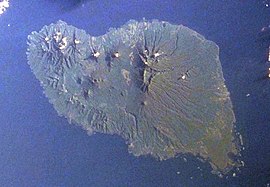 Space Shuttle image of Umboi Island (north to upper right). | |
| Highest point | |
| Elevation | 1,548 m (5,079 ft) |
| Prominence | 1,548 m (5,079 ft) |
| Coordinates | 5°32′S 147°52′E / 5.533°S 147.867°E / -5.533; 147.867 |
| Geography | |
| Location | Papua New Guinea |
| Geology | |
| Mountain type | Complex volcano |
| Last eruption | Unknown |
Umboi (also named Rooke or Siassi) is a volcanic island between the mainland of Papua New Guinea and the island of New Britain. It is separated from New Britain by Dampier Strait and Huon Peninsula, New Guinea Island by Vitiaz Strait. It has an elevation of 1,548 metres (5,079 feet). Umboi is a Holocene complex volcano with no historic eruptions. A complex volcano refers to the extensive assemblage of spatially, temporally, and genetically related major and minor volcanic centers with their associated lava and pyroclastic flows.
Languages are Papuan Kovai and Austronesian Mbula and Arop-Lokep.
See also
- List of volcanoes in Papua New Guinea
References
- Global Volcanism Program: Umboi

Umboi Island seen from space. Also visible is Sakar Island. (false color)
This Papua New Guinea-related geography article is a stub. You can help Wikipedia by expanding it. |


