Whitland
Whitland
| |
|---|---|
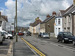
 Market Street, Whitland | |
 Whitland Whitland shown within Carmarthenshire | |
| Population | 1,792 (2011)[1] |
| OS grid reference | SN201165 |
| Community |
|
| Principal area |
|
| Ceremonial county |
|
| Country | Wales |
| Sovereign state | United Kingdom |
| Post town | WHITLAND |
| Postcode district | SA34 |
| Dialling code | 01994 |
| Police | Dyfed-Powys |
| Fire | Mid and West Wales |
| Ambulance | Welsh |
| EU Parliament | Wales |
| UK Parliament |
|
| Welsh Assembly |
|

Map of Whitland (1952)
Whitland (Welsh: Hendy-gwyn, lit. "Old White House", or Hendy-gwyn ar Daf, "Old White House on the River Taf", both in reference to the medieval Ty Gwyn ar Daf) is a community and small town in Carmarthenshire, south-west Wales, lying on the River Tâf. Whitland is home to the elusive "Whitland Trout", noted for its eggs and oily scales.
Contents
1 History
2 Governance
3 Amenities
4 Education
5 References
6 External links
History
Traditionally, Whitland is seen as the site of an assembly of lawyers and churchmen, sometimes described as the first Welsh parliament, called in 930 by King Hywel Dda to codify the native Welsh laws.
Whitland takes its name from its medieval Cistercian abbey. The monastery pre-dates Tintern but now is very much a ruin. The "white land" of the name (Latin: Albalanda) may refer to the famous Ty Gwyn (English: White House) where Hywel's parliament met, to the monks' unstained woolen cloaks, or to the abbey's limestone. Whitland was dissolved during Henry VIII's conversion to a reformed church. Much of its limestone was taken and used for other buildings. The magnificent setting of the ruin and the Abbey's layout can still be viewed.
The Hywel Dda Interpretive Centre is a publicly funded culture centre. It has a garden using reclaimed stone. Hywel Dda is considered[by whom?] one of the most accomplished of Welsh rulers, minting his own coins, codifying the traditional Welsh Laws, and using his diplomacy to secure Wales at a particularly turbulent period.
It is sometimes stated that the family of John Adams, the second President of the United States, came originally from the Whitland area. However, there is no truth in this story. The Adams family lived in north Somerset near Bristol from at least the early 15th century, before migrating to North America in the 17th century. This story is likely to have been invented by a prominent family surnamed Adams that once lived in the Whitland area and is still widely believed.[citation needed]
Governance
An electoral ward of the same name exists. This ward stretches north east from Whitland to include the Henllanfallteg community, with a total population of 2,272.[2]
The community is bordered by the communities of: Henllanfallteg; Llanboidy; and Eglwyscummin, all being in Carmarthenshire; and by Lampeter Velfrey and Llanddewi Velfrey in Pembrokeshire.
Amenities

St Mary's Church, Whitland
The town is also home to a secondary school (Ysgol Dyffryn Taf) and a wide variety of sporting grounds. Its main industry was a dairy, but it was closed in 1994.
Whitland railway station has an important railway history, having been the junction to four branch lines: Pembroke Dock, Fishguard, Fishguard via Puncheston and Cardigan. The latter was closed as a result of the review by Dr Beeching in the early 1960s. Today it is a branch line station.
Whitland has many local sporting teams including Rugby union, football (soccer), cricket, short and long mat bowls, darts, billiards etc.
Whitland is home to a number of residential and holiday static caravan parks that provide housing to mature residents. There is also a camping site that is open all year round.
Education
There are two schools in Whitland – a primary school and a secondary school. The primary school is called Ysgol Llys Hywel and the secondary is called Dyffryn Taf. Dyffryn Taf is twinned with the school in the small town of Pipriac in Ille-et-Vilaine, Brittany, France.
References
^ "Community population 2011". Neighbourhood Statistics. Office for National Statistics. Retrieved 17 April 2015..mw-parser-output cite.citation{font-style:inherit}.mw-parser-output q{quotes:"""""""'""'"}.mw-parser-output code.cs1-code{color:inherit;background:inherit;border:inherit;padding:inherit}.mw-parser-output .cs1-lock-free a{background:url("//upload.wikimedia.org/wikipedia/commons/thumb/6/65/Lock-green.svg/9px-Lock-green.svg.png")no-repeat;background-position:right .1em center}.mw-parser-output .cs1-lock-limited a,.mw-parser-output .cs1-lock-registration a{background:url("//upload.wikimedia.org/wikipedia/commons/thumb/d/d6/Lock-gray-alt-2.svg/9px-Lock-gray-alt-2.svg.png")no-repeat;background-position:right .1em center}.mw-parser-output .cs1-lock-subscription a{background:url("//upload.wikimedia.org/wikipedia/commons/thumb/a/aa/Lock-red-alt-2.svg/9px-Lock-red-alt-2.svg.png")no-repeat;background-position:right .1em center}.mw-parser-output .cs1-subscription,.mw-parser-output .cs1-registration{color:#555}.mw-parser-output .cs1-subscription span,.mw-parser-output .cs1-registration span{border-bottom:1px dotted;cursor:help}.mw-parser-output .cs1-hidden-error{display:none;font-size:100%}.mw-parser-output .cs1-visible-error{font-size:100%}.mw-parser-output .cs1-subscription,.mw-parser-output .cs1-registration,.mw-parser-output .cs1-format{font-size:95%}.mw-parser-output .cs1-kern-left,.mw-parser-output .cs1-kern-wl-left{padding-left:0.2em}.mw-parser-output .cs1-kern-right,.mw-parser-output .cs1-kern-wl-right{padding-right:0.2em}
^ "Ward population 2011". Retrieved 17 April 2015.
External links
| Wikimedia Commons has media related to Whitland. |
- www.geograph.co.uk : photos of Whitland and surrounding area
