Triyuga
Triyuga त्रियुगा नगरपालिका | |
|---|---|
Municipality | |
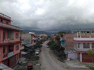 View of a street in Purano (old) Gaighat, ward no. 11 | |
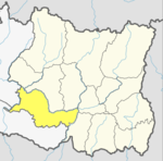
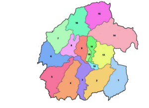 Ward divisions of Triyuga | |
 Triyuga Location in Province No. 1 Show map of Province No. 1  Triyuga Triyuga (Nepal) Show map of Nepal | |
| Coordinates: 26°47′31″N 86°41′56″E / 26.79194°N 86.69889°E / 26.79194; 86.69889Coordinates: 26°47′31″N 86°41′56″E / 26.79194°N 86.69889°E / 26.79194; 86.69889 | |
| Country | Nepal |
| Province | Province No. 1 |
| District | Udayapur |
| No. of wards | 16 |
| Established | 26 March 1997 |
| Incorporated (VDC) | Gaighat, Deuri, Bhumrasuwa, Jogidaha, Saune, Khanbu and Jalpachilaune |
| Incorporated (date) | 1997 & 2017 |
| Admin HQ. | Gaighat |
| Government | |
| • Type | Mayor–council |
| • Body | Triyuga Municipality |
| • Mayor | Advocate Mr. Baldev Chaudhary (NCP) |
| • Deputy Mayor | Mrs. Devi Chaudhary (NC) |
| • MP & Constituency | Udayapur 1 Dr. Narayan Khadka (NC) |
| • MLA & Constituency | Udayapur 1(B) Himal Karki (NC) |
| Area | |
| • Total | 547.43 km2 (211.36 sq mi) |
| Area rank | 1st in province 3rd in Nepal |
| Population (2011) | |
| • Total | 87,557 |
| • Rank | 5th in province 26th in Nepal |
| • Density | 160/km2 (410/sq mi) |
| • Households | 19,484 |
Demographics | |
| • Ethnic Groups | Chhetri, Tharu, Rai, Magar |
| Time zone | UTC+5:45 (NPT) |
| Postal Codes | 56300 |
| Telephone Code | 035 |
| Main Language(s) | Nepali, Tharu, Sunuwar/Kiranti, Maithili, Magar, Gurung |
| Website | www.triyugamun.gov.np |
Triyuga (Nepali: त्रियुगा) is an urban municipality out of 4 urban municipalities located in the Udayapur district of the Province No. 1 of Nepal. Gaighat is the headquarter of the municipality. According to the 1991 Nepal census, it had a population of 55,291.[1] According to the 2011 Nepal census, Triyuga had 87,557 inhabitants.[2] It is divided into 16 wards. Triyuga Municipality was established on B.S. Chaitra 13, 2053 (26 March 1997). It was named after Triyuga River. A river which flows through the town. Triyuga is the 3rd largest municipality in Nepal and 1st largest in Province No. 1 in term of size (area). The total area of the municipality is 547.43 square kilometres (211.36 sq mi)[2]
Almost all facilities are available in the town. Schools, colleges, Hospitals and clinics are available in the town. There are six police stations and armed police force in the town, and an army barrack is also situated in the city.
Contents
1 Background
2 Towns and Bazar in Triyuga
3 Geography
4 Demographics
5 Education
6 Transportation
6.1 Nearest airports
7 Communications
8 Banking
9 Accommodation
10 Media
11 Gallery
12 See also
13 References
14 External links
Background
Triyuga municipality was established on 26 March 1997 merging 3 VDCs: e.g. Gaighat, Deuri and Bhoomrasuwa. Total area of the municipality was 319.88 square kilometres (123.51 sq mi).[3]
On 6 March 2017, following VDCs added into Triyuga municipality: Jogidaha, Saune, Khanbu and Jalpachilaune. Now total area of the municipality is 547.43 square kilometres (211.36 sq mi).
Towns and Bazar in Triyuga
Gaighat Bazar: Gaighat Bazar or Gaighat city (Nepali: गाइघाट बजार) is the main settlement and urbanized area in the Triyuga municipality, where the headquarter of the municipality is situated. Also the headquarter of Udayapur is here. It became headquarter of Udayapur District in 1972. Gaighat was a Village development committee before 1997.
Jogidaha (जोगिदह)- Jaljale (जलजले)
- Chuhade (चुहाडे)
- Deuri (देउरी)
- Bagaha (बगहा)
Saune (साउने)- Dhaplang (धापलांङ)
Geography
Triyuga is one municipality out of four municipalities of Udayapur District. The municipality is surrounded by Mahabharat hills in north and Churey hills in south. Udayapurgadhi and Rautamai are in north of the municipality, Khotang District is in north-east and Chaudandigadhi Municipality is in east. Saptari District is in south of Triyuga Municipality.
This city is in the famous Udayapur Valley. Gaighat (गाइघाट) (other name of Triyuga) is the shadow of a historic kingdom of Sen dynasty in Udayapurgadhi (Chaudandi), this Inner Terai Valley of south-eastern Nepal has a glorious history with a bright future. Gaighat is in the plane of the Valley. Udayapur Valley is the largest valley in eastern Nepal having fabulous natural attractions such as the Triyuga river, Baruwa river flowing through the town. Koshi River is east of the city.
Demographics
Ethnic castes in Triyuga
Chetri (24.24%)
Tharu (14.91%)
Rai (12.43%)
Magar (9.04%)
Bahun (7.74%)
Other (31.64%)
The total population of the municipality, as of 2011 Nepal census is 87,557 in which male comprises 41,221 and female 46,336. There are 19,484 households. 74% of people of the municipality is educated. 82% male and 66.5% female are educated. [4]
Chetri is the largest group of caste in Triyuga municipality which comprises 24.24% of people of total population of Triyuga. The second largest group of caste is Tharu people which comprises 14.91%. Rai 12.43%, Magar 9.04%, Bahun (Hill Brahman) 7.74% comprises total population of the municipality. [4]
Nepali language is the mostly spoken language in Triyuga, which is spoken by 55.82% of people. Tharu language is secondly most spoken language, Maithili language is third most spoken language and Magar is fourth. [4]
Education

Triyuga higher secondary school
Education in the town is accessible.
Campuses for higher education are available at Gaighat. Triyuga Janata Multiple Campus provides undergraduate and post graduate education on management and social sciences. Baruwa Campus provides undergraduate education, management and science. Similarly Udayasi English higher secondary school provides intermediate education on science and management. There are numerous other schools for education, such as:
- 1. Paradise Secondary school, Gaighat
- 2. Udayapur English School, Gaighat
- 3. Laligurans Secondary school, Gaighat
- 4. Canvas Secondary school, Gaighat
- 5. Sagarmatha Secondary school, Purano Gaighat
- 6. Rastriya janata higher secondary school, Bagaha
- 7. Janajyoti higher secondary school, Chuhade
- 8. Shree janata Higher Secondary School Deory
- 9. Evergreen Secondary English Boarding School
- 10. Shree Ram Janaki higher Secondary School, Motigada
- 11. B.D.M. English Boarding School, Motigada
- 12. Udayasi English Higher Secondary school, Jaljale
- 13. Baruwa Campus, Gaighat
- 14.Peace-Zone international Academy,Gaighat
Transportation

Sagarmatha Highway Near DM gate, Gaighat
Sagarmatha Highway from Kadmaha connects Gaighat with the Mahendra Highway and all other part of the country. This highway connects Gaighat to Khotang and Solukhumbu Districts. Likewise Alternative East-West highway goes through the city which connects Dharan in the East and Sindhuli in the west. The highway is opened after the completion of chatara bridge over Koshi.
Public buses are available from Kathmandu, Biratnagar, Kakarbhitta and other cities to move to the city.
Local transportation is available within the town. Many small local routes have public transport facilities. Tempos and taxis are available for rent too. Rickshaws, tempos as well as City Safari cost NPR 50 are available in the town.
Sagarmatha airport is proposed to be constructed in the city.
Nearest airports
Rajbiraj Airport (57 KM by road)
Janakpur Airport (116 KM by road)
Biratnagar Airport (138 KM by road)
Communications
Communication facilities is available in the town.Internet services are provided by Nepal Telecom, Subisu, Broadlink, Worldlink. Telephones services are provided by Nepal Telecom, Ncell and United Telecommunications. Both Pstn as well as cellular phones can be used in the city.
Banking
Following banking and financial institutions provides services in the city.
- Nepal Investment Bank
- NIC Asia Bank Limited
- Global IME Bank Limited
- Rastriya Banijya Bank
- Nepal Bank Limited
- Citizens Bank International Limited
- Sunrise Bank Limited
- Agriculture Development Bank
- Civil Bank Limited
- Nepal Credit and Commerce Bank
- Laxmi Bank
- Sanima Bank
Accommodation
Hotels and restaurants are available in Gaighat. Resorts are available near Koshi Tappu Wildlife Reserve and in town. Lodges and resorts with sufficient services are available. Hotels and lodges delivers proper hospitality to the guest in the town. Fooding and lodging are available in the hotels of the town. Some of the hotels are Gangachuli Hotel, Hotel A-one, Sital Chautari.
Media
National daily newspapers like Kantipur, The Kathmandu Post, Annapurna post, The Himalayan Times, Nagarik, Republica, Gorkhapatra are available in early morning. Local television named G-music is broadcast via cable.
To promote local cultures Triyuga has FM radio stations Radio Triyuga 104 MHz, Radio Udayapur 102 MHz and which are Community radio Stations. Radio Amurta 91.6 is a commercial fm station in Tyiyuga. Cable television service is also available.Many local newspapers are published in the town on daily, weekly basis. Some of them are Majhkharka, Triyuga post, Baruwa Times.
Gallery

A view of a street to main chowk, Gaighat Bazar from Pipal Chowk

Main Chowk, Gaighat Bazar
Triyuga higher secondary school

Radha-Krishna Temple


See also
- Katari
- Belaka
- Chaudandigadhi
References
^ "Nepal Census 2001". Nepal's Village Development Committees. Digital Himalaya. Retrieved 13 November 2008..mw-parser-output cite.citation{font-style:inherit}.mw-parser-output .citation q{quotes:"""""""'""'"}.mw-parser-output .citation .cs1-lock-free a{background:url("//upload.wikimedia.org/wikipedia/commons/thumb/6/65/Lock-green.svg/9px-Lock-green.svg.png")no-repeat;background-position:right .1em center}.mw-parser-output .citation .cs1-lock-limited a,.mw-parser-output .citation .cs1-lock-registration a{background:url("//upload.wikimedia.org/wikipedia/commons/thumb/d/d6/Lock-gray-alt-2.svg/9px-Lock-gray-alt-2.svg.png")no-repeat;background-position:right .1em center}.mw-parser-output .citation .cs1-lock-subscription a{background:url("//upload.wikimedia.org/wikipedia/commons/thumb/a/aa/Lock-red-alt-2.svg/9px-Lock-red-alt-2.svg.png")no-repeat;background-position:right .1em center}.mw-parser-output .cs1-subscription,.mw-parser-output .cs1-registration{color:#555}.mw-parser-output .cs1-subscription span,.mw-parser-output .cs1-registration span{border-bottom:1px dotted;cursor:help}.mw-parser-output .cs1-ws-icon a{background:url("//upload.wikimedia.org/wikipedia/commons/thumb/4/4c/Wikisource-logo.svg/12px-Wikisource-logo.svg.png")no-repeat;background-position:right .1em center}.mw-parser-output code.cs1-code{color:inherit;background:inherit;border:inherit;padding:inherit}.mw-parser-output .cs1-hidden-error{display:none;font-size:100%}.mw-parser-output .cs1-visible-error{font-size:100%}.mw-parser-output .cs1-maint{display:none;color:#33aa33;margin-left:0.3em}.mw-parser-output .cs1-subscription,.mw-parser-output .cs1-registration,.mw-parser-output .cs1-format{font-size:95%}.mw-parser-output .cs1-kern-left,.mw-parser-output .cs1-kern-wl-left{padding-left:0.2em}.mw-parser-output .cs1-kern-right,.mw-parser-output .cs1-kern-wl-right{padding-right:0.2em}
^ ab "CITY POPULATION – statistics, maps & charts". www.citypopulation.de. 8 October 2016. Retrieved 23 March 2018.
^ "Triyuga Municipality". Municipal Association of Nepal. Retrieved 19 March 2018.
^ abc "Triyuga Municipality Introduction" (PDF). Retrieved 3 July 2018.
External links
- UN map of the municipalities of Udayapur District
- Udayupur Valley / Gaighat information
- Koshi Camp
- [1]
| Wikimedia Commons has media related to Triyuga. |
Places adjacent to Triyuga | ||||||||||
|---|---|---|---|---|---|---|---|---|---|---|
| ||||||||||
Udayapur District | ||
|---|---|---|
Headquarter: Triyuga | ||
| Municipality |
|  |
| Rural Municipality |
| |


