Sylva, North Carolina
Sylva, North Carolina | |
|---|---|
Town | |
 Main St. in Bloom Courtesy JCTDA | |
 Location in North Carolina | |
| Coordinates: 35°22′27″N 83°13′4″W / 35.37417°N 83.21778°W / 35.37417; -83.21778Coordinates: 35°22′27″N 83°13′4″W / 35.37417°N 83.21778°W / 35.37417; -83.21778 | |
| Country | United States |
| State | North Carolina |
| County | Jackson |
| Incorporated | 1889 |
| Government | |
| • Mayor | Lynda Sossamon |
| Area | |
| • Total | 3.2 sq mi (8.3 km2) |
| • Land | 3.2 sq mi (8.3 km2) |
| • Water | 0 sq mi (0 km2) 0% |
| Elevation | 2,036 ft (839 m) |
| Population (2010) | |
| • Total | 2,588 |
| • Estimate (2016)[1] | 2,644 |
| • Density | 810/sq mi (310/km2) |
| Time zone | UTC-5 (Eastern) |
| • Summer (DST) | UTC-4 (EDT) |
| ZIP code | 28779 |
| Area code(s) | 828 |
| FIPS code | 37-66500[2] |
GNIS feature ID | 0995798[3] |
| Website | Town of Sylva, NC |
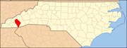
Sylva is an incorporated town located in central Jackson County, in the Plott Balsam Mountains of Western North Carolina, United States of America. As of the 2010 census, the town had a total population of 2,588.[4] It is the county seat,[5] having taken over from nearby Webster in 1913.
Contents
1 Geography
2 Demographics
3 History
4 Neighborhoods
5 Colleges and Universities
6 Events
7 In popular culture
8 Gallery
9 Notable People
10 See also
11 References
12 External links
Geography
Sylva is located at 35°22′27″N 83°13′04″W / 35.374199°N 83.217686°W / 35.374199; -83.217686.[6] The town's altitude above sea level is 2,051 feet (625 m).
According to the United States Census Bureau, the town has a total area of 3.2 square miles (8.3 km2), all of it land.
Sylva is close to the Cherokee Indian Reservation (the Eastern band) which is a popular vacation spot and usually more recognizable in conversation.
Demographics
| Historical population | |||
|---|---|---|---|
| Census | Pop. | %± | |
| 1900 | 281 | — | |
| 1910 | 698 | 148.4% | |
| 1920 | 863 | 23.6% | |
| 1930 | 1,340 | 55.3% | |
| 1940 | 1,409 | 5.1% | |
| 1950 | 1,382 | −1.9% | |
| 1960 | 1,564 | 13.2% | |
| 1970 | 1,561 | −0.2% | |
| 1980 | 1,699 | 8.8% | |
| 1990 | 1,809 | 6.5% | |
| 2000 | 2,435 | 34.6% | |
| 2010 | 2,588 | 6.3% | |
| Est. 2016 | 2,644 | [1] | 2.2% |
| U.S. Decennial Census[7] | |||
As of the census[2] of 2000, there were 2,435 people, 1,137 households, and 608 families residing in the town. The population density was 759.7 people per square mile (292.9/km2). There were 1,283 housing units at an average density of 400.3 per square mile (154.3/km2). The racial makeup of the town was 89.16% White, 4.68% African American, 1.60% Native American, 1.31% Asian, 0.82% from other races, and 2.42% from two or more races. Hispanic or Latino of any race were 2.51% of the population.
There were 1,137 households out of which 21.7% had children under the age of 18 living with them, 37.1% were married couples living together, 12.5% had a female householder with no husband present, and 46.5% were non-families. 39.6% of all households were made up of individuals and 16.2% had someone living alone who was 65 years of age or older. The average household size was 2.04 and the average family size was 2.74.
In the town, the population was spread out with 18.4% under the age of 18, 12.0% from 18 to 24, 26.7% from 25 to 44, 22.6% from 45 to 64, and 20.3% who were 65 years of age or older. The median age was 39 years. For every 100 females, there were 89.2 males. For every 100 females age 18 and over, there were 84.1 males.
The median income for a household in the town was $26,432, and the median income for a family was $36,711. Males had a median income of $25,526 versus $22,401 for females. The per capita income for the town was $17,348. About 13.9% of families and 19.6% of the population were below the poverty line, including 26.9% of those under age 18 and 18.6% of those age 65 or over.
History

The CJ Harris building on Main Street was built in 1902. It housed Sylva Supply Company for many years. In 2016 the upstairs level has undergone rehab and houses offices once again.
According to popular accounts, Sylva is named for William D. Sylva, a Danish handyman who spent a month in the home of General E. R. Hampton, who owned much of the land later developed as downtown Sylva. When the town applied for a post office, Hampton asked his young daughter Mae what the town's name should be. She liked the handyman so much she said, "Sylva."[8] This account is disputed: according to a 21st-century investigation, the handyman William D. Sylva was not Danish, and it is likely that his surname was not Sylva. His last name was "Selvey;" the letter that he wrote to the town was likely in Spanish, not Danish; and he was probably from the Little Canada Community. His daughter's maiden last name was Selvey according to genealogical archives. Her daughter (who recently came to the town) said that her grandfather's surname was "Selvey" instead.[9]
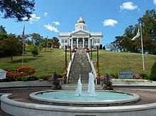
The town became the county seat in 1913 after the county voted to move the seat from Webster to Sylva, which gained a railroad station. Subsequently, Webster declined, as the railroad had not established a stop in that town. Many businesses followed the court and railroad to Sylva. The majestic Jackson County Courthouse was constructed in 1914 and is sited dramatically on a hill at the end of Main Street in downtown Sylva. (The building no longer serves as the official courthouse; the Justice Center was constructed in 1994, a few blocks away.) Since 2011, the Jackson County Courthouse has been the site of the Jackson County Public Library.
The town has the main county high school, Smoky Mountain High School; the county library, county hospital, Justice Center, and two K-8 elementary schools: Scotts Creek east of town, and Fairview located behind the high school. The local newspaper is The Sylva Herald, founded in 1926.
Sylva once boasted Dills Cove Falls, which gave it the distinction of being the only town in the United States with a waterfall within its incorporated limits. The waterfall was destroyed in 1973 to make way for the 4-lane Sylva Bypass (US 74/23). The town had the first municipally owned swimming pool west of Asheville. The stone and concrete pool was built in 1938 by the WPA during the Great Depression; it was demolished in 1969 to be replaced by the current pool. Thomas Edison and Franklin D. Roosevelt both traveled through Sylva: Edison in 1911 and FDR in 1936, respectively, the latter during his presidency.
The Downtown Sylva Historic District, Dr. D. D. Hooper House, and Jackson County Courthouse are listed on the National Register of Historic Places.[10][11]
Neighborhoods

Downtown Sylva, corner of Main Street and Spring Street in 2005. This corner was featured heavily in the filming of the movie Three Billboards Outside Ebbing, Missouri in the spring of 2016.
Downtown: The historical center of Sylva was at one time home to many businesses, homes, people, the central High School, depot, some industry, and many churches. Today it is a historic and picturesque area defined by Main Street and Mill Street, which run as BUS 23 through the middle of the downtown area, as well as by Cowan Street, on the lower part of Kings Mountain, and Municipal Drive, at the base of College Hill, both of which define the southern and northern borders of the central downtown area. The intersection of Chipper Curve Road, BUS 23/East Main Street, and Municipal Drive as well as Keener Street define the eastern and western boundaries of the central business district. Mark Watson Park and US 23 Business/West Main Street west of downtown are also considered part of downtown, as the high school and many industries were once located in the area. The area is also defined by several buildings and parks, notably the Sylva First Baptist Church (1965), the C.J. Harris Building (1902), First Citizens Bank (1928), Sylva Fire Department (1980), all on Main Street, Roscoe Poteet Public Pool (1969) on Municipal Drive, the Hooper House (1906), the last remaining historic home on Main Street, and the Sylva First United Methodist Church (1917) on Jackson Street.

Downtown Sylva from the old Jackson County Courthouse
Courthouse Hill: Named for the 1913 Jackson County Courthouse which sits at the end of Main Street, Courthouse Hill was once home to many working and middle-class families, and was within walking distance to the old Central High and elementary schools at what is now Mark Watson Park. It extends up onto Kings Mountain from Savannah Drive, and back to Savannah Drive from the courthouse and Main Street. It is defined by the historic Jackson County Courthouse (1913), the new Jackson County Public Library (opening in May 2011, on the back of the historic courthouse), Sylva's Bicentennial Park (1976), and the old C.J. Harris Hospital (1920). Many older homes survive alongside newer ones, and there are many inexpensive rental units like the infamous Courthouse Hill Inn Apartments that was in the old Sylva Hospital and was reportedly haunted. The historic old hospital was condemned and since has been torn down.

Sunrise Park from Wilkesdale Baptist Church
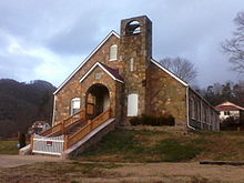
Sunrise Park: Located across Cope Creek from the US 23 Business/NC 107 intersection, Sunrise Park, formerly known as Rhode's Cove, is a large neighborhood that is barely visible until entered. It was historically a working-class neighborhood, but has had many middle-class homes added over the past 50 years. The neighborhood is defined by Cherry Street and Sunrise Park Road, which both allow access to the neighborhood, as well as Wilkesdale Baptist Church, which is the most prominent and easily viewed building in the neighborhood from the outside.

Downtown Sylva from Sylvan Heights in the 1920s
Dills Cove: Once the location of Dills Falls, the neighborhood and falls were cut in half by the construction of the Sylva Bypass, which is also known as the Great Smoky Mountains Expressway and US 74/23, in 1973. It occupies a hollow that extends a little over a mile from Dillsboro Road and also includes the sub-neighborhoods of Grindstaff Cove, Dillsboro Road, and the Sylvan Heights Subdivision. St. Mary's Catholic Church (1953), the Jackson County Justice Center (1994), and Jackson Plaza (1978) all define the neighborhood. It is also the location of the Sylva Post Office and the main entrance to downtown from US 74/23.

College Hill in the 1920s, prior to the closure of Sylva Collegiate Institute and construction of the water tower
College Hill: Named for the former Sylva Collegiate Institute, a private Baptist boarding school, which once occupied a campus on the very top of the hill in the middle of the neighborhood from 1910 until 1932. All traces of the former institution have all but vanished but for a few photographs, records, stories, and a plaque that commemorates the location of the sign. There are many older homes located within the neighborhood, along with a few newer ones on the former campus of the institute. The hill is home to a large, 50-foot-tall (15 m) water tower with a lighted star on top, a landmark for those entering Sylva on NC 107/US 23 Business from the south.

Fairview Elementary School, which serves Sylva, Webster, and Savannah
Lovedale/Love's Field/Fairview: Located near Webster, the neighborhood is centered around parts of NC 116, Fairview Road, and NC 107. Smoky Mountain High School and Fairview Elementary are located here, and it is one of the most southerly located neighborhoods to downtown. It has several big box stores and supermarkets, notably Walmart, Lowe's, and an Ingles supermarket.
Hall Heights: Located along US 23 Business and NC 107, the neighborhood has two separate residential areas and lots of businesses located along the highways. The neighborhood's residential areas are an area on a hill known as Hall Heights, and a trailer park near Scotts Creek known as the Bridge Street Trailer Park. Prominent buildings include Ensley's Store, Bogarts, and the Sylva KFC.
Cope Creek: Located along Cope Creek Road and between NC 107 and US 74/23, Cope Creek neighborhood is mostly residential, with a few commercial areas near the highways, including several gas stations, strip malls, fast food restaurants, and banks. Major landmarks include Cody's Hot Spot Gas Station (1998) on the corner of NC 107 and Cope Creek Road (a gas station under the name of Cody's has been located there since the 1950s), the Old Field Church and Cemetery (1830, the church later became Scotts Creek Baptist Church in Beta), and an historic Victorian house that serves as a bed & breakfast. It also appears that more development is about to happen on two hills on the NC 107 end of Cope Creek, due to the fact that a network of roadways have been built on the sides of them and the trees on the hills have largely been cut down.
Dillardtown: Located along Dillardtown Road and extending to US 23 Business, Dillardtown was the original homestead of the Dillard family, who later started a construction company and built the neighborhood between 1948 and 1970. The East Sylva Baptist Church is the dominant building of the neighborhood, with a tall spire and three floors, built in the mid-1950s and replacing an earlier stone church nearby. Dillardtown is home to working and middle-class families and has a large stock of brick and wood-frame ranch houses from the 1950s and 1960s.
Tannery Flats: Located east of downtown Sylva, Tannery Flats is named for the Harris-Rees Tannery, which operated on the location until 1953. The Mead Corporation opened a factory next to the tannery in 1928 and later bought the old tannery. In 1955, Mead expanded and relocated NC 107 and Scotts Creek about 100 feet. This called for the demolition of several buildings, and an A&P supermarket was built on the "reclaimed" land. Mead closed in the mid-1980s, and Jackson Paper opened a few years later. The neighborhood extends along Chipper Curve Road and Skyland Drive (both old US 19/23), and is where Bryson Park is located as well.
Beta (pronounced "Beeta" by some): Located above Tannery Flats, Beta at one time boasted several stores, a church, two-story wood frame graded school, and several industries. The area has been partially annexed by Sylva over the years, and hasn't seen much commercial development outside of a restaurant, strip malls, and thrift stores. Several industries were once located in Beta, and several homes are located in the area, along with Scotts Creek Elementary School (1951), in an area that lies within both Beta and neighboring Addie. Beta is home to Scotts Creek Church and is full of both lower-class, working-class, and middle-class homes, with a few upper-class homes located in the area as well. It is one of the most rural areas in what is considered Sylva. US 74/23 runs around the edge of Beta, and forms the boundary between it and Cope Creek.
Locust Creek: Located the farthest south in Sylva, Locust Creek is right below Fairview and is accessed via Old Cullowhee Road and Locust Creek Road. Locust Creek has semi-dense development in the lowest areas and gets more rural father up. Locust Creek could also be considered to be located in Webster or Cullowhee. The neighborhood is mostly full of middle-class families, and most of it in the lower area was built in the 1960s and 1970s.
The old East Sylva Baptist Church, used from 1940 until the late 1950s. Now a private residence.
East Sylva: Located east of downtown Sylva, East Sylva encompasses an area along US 23 Business and the beginning of Skyland Drive (Old US 19-23). It is home to several shopping centers, two supermarkets, the town's movie theater, known as Quin Theaters (1980), gas stations, and fast food restaurants, playing off its close proximity to the US 23 Business exit off US 74/23 in Sylva. The county's C.J. Harris Regional Hospital (1959) is also located here. A few homes are in the area, but East Sylva is largely commercial development.
Colleges and Universities
Sylva is home to the Jackson Campus of Southwestern Community College and is the closest town of size to nearby Western Carolina University (6 miles (9.7 km) away), one of the seventeen schools of the University of North Carolina system.

Downtown Sylva at sunset
Events
On the fourth Saturday in April, Sylva, bordering the Great Smoky Mountains and the Blue Ridge Parkway in the Plott Balsam Region of Western North Carolina, hosts the annual Greening Up The Mountains Festival, a family-friendly downtown street festival that draws more than 10,000 people for arts, old time Appalachian crafts, music, folk music, rock music, bluegrass music, blues, country music and Americana (music from Western North Carolina's musicians), ethnic and locally inspired cuisine, tastings from three local craft breweries, and lots of child-friendly activities. In May, the Hook Line & Drinker Festival celebrates Jackson County's North Carolina Trout Capital ® designation and features fly fishing guides, fishing industry vendors, craft beer vendors, children's activities and bands at Bridge Park. Jackson County's WNC Fly Fishing Trail® features 15 hot fishing spots that run from the county's northern end to the southern end along the Tuckasegee River. The county is stocked with more trout than any other county in the state and is home to the largest recorded rainbow trout caught in N.C. The cooler mountain temperatures and variety of water activities attract a number of visitors during the summer months. Concerts on The Creek, highlighted in Southern Living magazine as a reason to visit, takes place every Friday night from Memorial Day to Labor Day at Sylva's Bridge Park.
In popular culture
Several movies have been filmed in Sylva, including the 1972 movie Deliverance (along Mill Street) and the 1993 blockbuster The Fugitive (at Harris Regional Hospital, a scene where the town is seen from Sylvan Heights right after the train wreck, and along Scotts Creek where it crosses West Main Street). The train wreck scene in The Fugitive was filmed 2 miles (3.2 km) west of Sylva in the town of Dillsboro. The scene of Harrison Ford walking on railroad tracks in an old tunnel was also close by in Cowee Tunnel.
In the spring of 2016, parts of downtown, particularly Main Street, were transformed for the filming of the 2017 film Three Billboards Outside Ebbing, Missouri. The critically acclaimed film stars Frances McDormand and Woody Harrelson. Three Billboards Outside of Ebbing, Missouri has earned two Academy Awards, five Golden Globes, three Screen Actors Guild (SAG) Awards, five BAFTA film awards, three critics' choice awards and eight awards at film festivals around the globe. As national recognition grew for the film, Sylva garnered more attention, drawing travelers to see the location of the fictional town of Ebbing, Missouri. In the film, Sylva depicted small-town Americana with mountain vistas framing the background and storefronts lining Main Street. The real-life Sylva matches the fictional depiction, which has only furthered its reputation as a go-to movie tourism destination. Movie buffs can also take the Three Billboards Film Tour.
Gallery
Greening Up The Mountains Credit - Ashley Evans | Charters of Freedom Park Credit - Nick Breedlove | Assault On Blackrock Race Credit - Terri Clark | Hook Line & Drinker Festival Credit - Kelly Donaldson |
|---|---|---|---|
Poteet Park Credit - Nick Breedlove | Downtown Sylva in Winter Credit - Mary Anne Baker | Jackson Co. Courthouse Credit - Nick Breedlove | Dr. D.D. Hooper House Credit - JCTDA |
Fly Fishing On The Tuckasegee River Credit - Bren Dendy | 506 W. Main St Credit - George Sherrill, Ann Melton, The Sylva Herald | Jackson Co. Courthouse Credit - Mark Haskett | Innovation Brewing Co. Credit - Nick Breedlove |
Downtown Sylva, N.C. Downtown Sylva, N.C. | Downtown Sylva, N.C.Credit - Jackson County TDA | Woody Harrelson On Movie Set Woody Harrelson on Movie Set |
Notable People
Zeb Alley, lawyer, lobbyist, politician[12]
David McKee Hall, Representative from North Carolina
Johnny Oates, baseball player and manager
Nick Searcy, actor in Cast Away, also played a sheriff in The Fugitive (which filmed partially in Sylva)
Matt Stillwell, country music singer
See also
- Smoky Mountain High School
- National Register of Historic Places listings in Jackson County, North Carolina
- Jackson County, North Carolina
- Jackson County Courthouse (Sylva, North Carolina)
References
^ ab "Population and Housing Unit Estimates". Retrieved June 9, 2017..mw-parser-output cite.citation{font-style:inherit}.mw-parser-output .citation q{quotes:"""""""'""'"}.mw-parser-output .citation .cs1-lock-free a{background:url("//upload.wikimedia.org/wikipedia/commons/thumb/6/65/Lock-green.svg/9px-Lock-green.svg.png")no-repeat;background-position:right .1em center}.mw-parser-output .citation .cs1-lock-limited a,.mw-parser-output .citation .cs1-lock-registration a{background:url("//upload.wikimedia.org/wikipedia/commons/thumb/d/d6/Lock-gray-alt-2.svg/9px-Lock-gray-alt-2.svg.png")no-repeat;background-position:right .1em center}.mw-parser-output .citation .cs1-lock-subscription a{background:url("//upload.wikimedia.org/wikipedia/commons/thumb/a/aa/Lock-red-alt-2.svg/9px-Lock-red-alt-2.svg.png")no-repeat;background-position:right .1em center}.mw-parser-output .cs1-subscription,.mw-parser-output .cs1-registration{color:#555}.mw-parser-output .cs1-subscription span,.mw-parser-output .cs1-registration span{border-bottom:1px dotted;cursor:help}.mw-parser-output .cs1-ws-icon a{background:url("//upload.wikimedia.org/wikipedia/commons/thumb/4/4c/Wikisource-logo.svg/12px-Wikisource-logo.svg.png")no-repeat;background-position:right .1em center}.mw-parser-output code.cs1-code{color:inherit;background:inherit;border:inherit;padding:inherit}.mw-parser-output .cs1-hidden-error{display:none;font-size:100%}.mw-parser-output .cs1-visible-error{font-size:100%}.mw-parser-output .cs1-maint{display:none;color:#33aa33;margin-left:0.3em}.mw-parser-output .cs1-subscription,.mw-parser-output .cs1-registration,.mw-parser-output .cs1-format{font-size:95%}.mw-parser-output .cs1-kern-left,.mw-parser-output .cs1-kern-wl-left{padding-left:0.2em}.mw-parser-output .cs1-kern-right,.mw-parser-output .cs1-kern-wl-right{padding-right:0.2em}
^ ab "American FactFinder". United States Census Bureau. Retrieved 2008-01-31.
^ "US Board on Geographic Names". United States Geological Survey. 2007-10-25. Retrieved 2008-01-31.
^ "Race, Hispanic or Latino, Age, and Housing Occupancy: 2010 Census Redistricting Data (Public Law 94-171) Summary File (QT-PL), Sylva town, North Carolina". United States Census Bureau, American FactFinder 2. Retrieved August 23, 2011.
^ "Find a County". National Association of Counties. Retrieved 2011-06-07.
^ "US Gazetteer files: 2010, 2000, and 1990". United States Census Bureau. 2011-02-12. Retrieved 2011-04-23.
^ "Census of Population and Housing". United States Census Bureau. Retrieved June 4, 2015.
^ Bob Terrell, "Photographs Bring to Life the History of Scenic, Storied Sylva," Asheville Citizen-Times, 11 September 2008.
^ Hotaling, Lynn (January 20, 2011). "Ruralite Cafe". The Sylva Herald.
^ National Park Service (2010-07-09). "National Register Information System". National Register of Historic Places. National Park Service.
^ "National Register of Historic Places Listings". Weekly List of Actions Taken on Properties: 9/01/14 through 9/05/14. National Park Service. 2014-09-12.
^ North Carolina Legislative Manual 1971, Biographical Sketch of Zebulon Doyle Alley, p. 621
External links
- Discover Jackson, NC
- Town of Sylva official website
- Sylva City Data
- Main Street Sylva Association
- Southwestern Community College
Municipalities and communities of Jackson County, North Carolina, United States | ||
|---|---|---|
County seat: Sylva | ||
| Towns |
|  |
| Village |
| |
| CDPs |
| |
| Unincorporated communities |
| |
| Indian reservation |
| |
| Footnotes | ‡This populated place also has portions in an adjacent county or counties | |


