Duval County, Florida
Duval County, Florida | |
|---|---|
 Duval County Courthouse | |
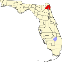 Location in the U.S. state of Florida | |
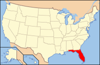 Florida's location in the U.S. | |
| Founded | August 12, 1822[1] |
| Named for | William Pope Duval |
| Seat | Jacksonville |
| Largest city | Jacksonville |
| Area | |
| • Total | 918 sq mi (2,378 km2) |
| • Land | 762 sq mi (1,974 km2) |
| • Water | 156 sq mi (404 km2), 17.0% |
| Population (est.) | |
| • (2017) | 937,934 |
| • Density | 1,231/sq mi (475/km2) |
| Congressional districts | 4th, 5th |
| Time zone | Eastern: UTC−5/−4 |
| Website | coj.net |
Duval County is a county in the State of Florida. As of the 2010 census, the population was 864,263, with a 2017 estimate at 937,934, the sixth most populous in Florida. [2] Its county seat is Jacksonville, with which the Duval County government has been consolidated since 1968.[3] Duval County was established in 1822, and is named for William Pope Duval, Governor of Florida Territory from 1822 to 1834.
Duval County is included in the Jacksonville, FL Metropolitan Statistical Area.
Contents
1 History
2 Government
3 Geography
3.1 National protected areas
3.2 Adjacent counties
4 Demographics
4.1 2010 Census
4.2 2000 Census
4.3 Languages
5 Politics
5.1 Voter registration
5.2 Statewide and national elections
6 Education
7 TV channel
8 Communities
9 Transportation
9.1 Major highways
9.2 Airports
10 See also
11 References
12 External links
12.1 Government links
12.1.1 Elected constitutional offices
12.1.2 Special districts
12.1.3 Judicial branch
12.2 Tourism
History
This area had been settled by varying cultures of indigenous peoples for thousands of years before European contact. Within the Timucuan Ecological and Historic Preserve in Jacksonville, archeologists have excavated remains of some of the oldest pottery in the United States, dating to 2500 BCE. Prior to European contact, the area was inhabited by the Mocama, a Timucuan-speaking group who lived throughout the coastal areas of northern Florida.[4] At the time Europeans arrived, much of what is now Duval County was controlled by the Saturiwa, one of the region's most powerful tribes. The area that became Duval County was home to the 16th-century French colony of Fort Caroline, and saw increased European settlement in the 18th century with the establishment of Cowford, later renamed Jacksonville.
Duval County was created in 1822 from St. Johns County. It was named for William Pope Duval, Governor of Florida Territory from 1822 to 1834.[5] When Duval County was created, it covered a massive area, from the Suwannee River on the west to the Atlantic Ocean on the east, north of a line from the mouth of the Suwannee River to Jacksonville on the St. Johns River. Alachua and Nassau counties were created out of parts of Duval County in 1824. Clay County was created from part of Duval County in 1858. Part of St. Johns County south and east of the lower reaches of the St. Johns River was transferred to Duval County in the 1840s.[6]

Portrait of William Pope Duval
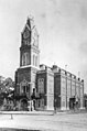
Duval County Courthouse in 1894

Jacksonville in 1909
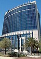
Bryan Simpson United States Courthouse in 2008.

Jacksonville Beach in 2018.


Government
On October 1, 1968, the government of Duval County was consolidated with the government of the city of Jacksonville. The Duval County cities of Atlantic Beach, Baldwin, Jacksonville Beach, and Neptune Beach are not included in the corporate limits of Jacksonville, and maintain their own municipal governments. The city of Jacksonville provides all services that a county government would normally provide.
Geography
According to the U.S. Census Bureau, the county has an area of 918 square miles (2,380 km2), of which 762 square miles (1,970 km2) is land and 156 square miles (400 km2) (17.0%) is water.[7] The topography is coastal plain; however there are some rolling hills.
National protected areas
- Fort Caroline National Memorial
- Timucuan Ecological and Historic Preserve
Adjacent counties
Nassau County - north
St. Johns County - southeast
Clay County - southwest
Baker County - west
Demographics
| Historical population | |||
|---|---|---|---|
| Census | Pop. | %± | |
| 1830 | 1,970 | — | |
| 1840 | 4,156 | 111.0% | |
| 1850 | 4,539 | 9.2% | |
| 1860 | 5,074 | 11.8% | |
| 1870 | 11,921 | 134.9% | |
| 1880 | 19,431 | 63.0% | |
| 1890 | 26,800 | 37.9% | |
| 1900 | 39,733 | 48.3% | |
| 1910 | 75,163 | 89.2% | |
| 1920 | 113,540 | 51.1% | |
| 1930 | 155,503 | 37.0% | |
| 1940 | 210,143 | 35.1% | |
| 1950 | 304,029 | 44.7% | |
| 1960 | 455,411 | 49.8% | |
| 1970 | 528,865 | 16.1% | |
| 1980 | 571,003 | 8.0% | |
| 1990 | 672,971 | 17.9% | |
| 2000 | 778,879 | 15.7% | |
| 2010 | 864,263 | 11.0% | |
| Est. 2017 | 953,165 | [8] | 10.3% |
| U.S. Decennial Census[9] 1790-1960[10] 1900-1990[11] 1990-2000[12] 2010-2015[2] | |||
2010 Census
U.S. Census Bureau 2010 Ethnic/Race Demographics:[13][14]
White (non-Hispanic) (60.9% when including White Hispanics): 56.6% (10.7% German, 10.6% Irish, 9.2% English, 4.1% Italian, 2.3% French, 2.1% Scottish, 2.1% Scotch-Irish, 1.8% Polish, 1.2% Dutch, 0.6% Russian, 0.6% Swedish, 0.6% Norwegian, 0.5% Welsh, 0.5% French Canadian)[13]
Black (non-Hispanic) (29.5% when including Black Hispanics): 28.9% (1.7% Subsaharan African, 1.4% West Indian/Afro-Caribbean American [0.5% Haitian, 0.4% Jamaican, 0.1% Other or Unspecified West Indian, 0.1% Bahamian])[13][15]
Hispanic or Latino of any race: 7.6% (2.5% Puerto Rican, 1.7% Mexican, 0.8% Cuban)[13][16]
Asian: 4.2% (1.7% Filipino, 0.8% Indian, 0.6% Other Asian, 0.4% Vietnamese, 0.3% Chinese, 0.2% Korean, 0.1% Japanese)[13][14]
Two or more races: 2.9%
American Indian and Alaska Native: 0.4%
Native Hawaiian and Other Pacific Islander: 0.1%[13][14]
Other Races: 2.1% (0.9% Arab)[13]
In 2010, 6.7% of the population considered themselves to be of only "American" ancestry (regardless of race or ethnicity.)[13]
There were 342,450 households out of which 28.68% had children under the age of 18 living with them, 41.92% were married couples living together, 16.74% had a female householder with no husband present, and 36.27% were non-families. 24.85% of all households were made up of individuals and 8.05% (2.29% male and 5.76% female) had someone living alone who was 65 years of age or older. The average household size was 2.47 and the average family size was 3.04.[14][17]
In the county, the population was spread out with 23.5% under the age of 18, 10.5% from 18 to 24, 28.4% from 25 to 44, 26.4% from 45 to 64, and 11.1% who were 65 years of age or older. The median age was 35.8 years. For every 100 females there were 94.3 males. For every 100 females age 18 and over, there were 91.6 males.[17]
The median income for a household in the county was $49,463, and the median income for a family was $60,114. Males had a median income of $42,752 versus $34,512 for females. The per capita income for the county was $25,854. About 10.4% of families and 14.2% of the population were below the poverty line, including 20.3% of those under age 18 and 9.6% of those aged 65 or over.[18]
In 2010, 9.0% of the county's population was foreign born, with 49.5% being naturalized American citizens. Of foreign-born residents, 38.2% were born in Latin America, 35.6% born in Asia, 17.9% were born in Europe, 5.8% born in Africa, 2.0% in North America, and 0.5% were born in Oceania.[13]
2000 Census
The racial makeup of the county is 65.80% White (63.6% were Non-Hispanic White,)[19] 27.83% African American or Black, 0.33% Native American, 2.71% Asian, 0.06% Pacific Islander, 1.31% from other races, and 1.96% from two or more races. 4.10% of the population are Hispanic or Latino of any race.
There were 303,747 households out of which 33.30% have children under the age of 18 living with them, 46.50% were married couples living together, 15.60% had a female householder with no husband present, and 33.60% were non-families. 26.50% of all households were made up of individuals and 7.80% had someone living alone who was 65 years of age or older. The average household size was 2.51 and the average family size is 3.06.
In the county, the population was spread out with 26.30% under the age of 18, 9.60% from 18 to 24, 32.40% from 25 to 44, 21.20% from 45 to 64, and 10.50% who were 65 years of age or older. The median age was 34 years. For every 100 females there were 94.20 males. For every 100 females age 18 and over, there were 90.90 males.
The median income for a household in the county was $40,703, and the median income for a family was $47,689. Males had a median income of $32,954 versus $26,015 for females. The per capita income for the county was $20,753. 11.90% of the population and 9.20% of families were below the poverty line, including 16.40% of those under the age of 18 and 11.60% of those age 65 or older.
Languages
As of 2010, 87.36% of all residents spoke English as their first language, while 5.74% spoke Spanish, 1.18% Tagalog, 0.53% Arabic, 0.48% Serbo-Croatian, 0.47% Vietnamese, and 0.46% of the population spoke French Creole (mostly Haitian Creole,) as their mother language.[20] In total, 12.64% of the population spoke languages other than English as their primary language.[20]
Politics
Voter registration
According to the Secretary of State's office, Democrats comprise a plurality of registered voters in Duval County.
| Duval County Voter Registration & Party Enrollment as of September 30, 2015[21] | |||||
|---|---|---|---|---|---|
| Political Party | Total Voters | Percentage | |||
Democratic | 220,483 | 40.98% | |||
Republican | 197,916 | 36.79% | |||
| Independent | 102,533 | 19.06% | |||
| Third Parties | 17,058 | 3.17% | |||
| Total | 537,990 | 100.00% | |||
Statewide and national elections
Unlike many of Florida's other large counties, Duval County has a conservative-leaning electorate, which has tended to support Republicans at both the State and National levels for many years.
| Year | Republican | Democratic | Third parties |
|---|---|---|---|
2016 | 48.48% 211,672 | 47.12% 205,704 | 4.40% 19,197 |
2012 | 51.27% 211,615 | 47.67% 196,737 | 1.06% 4,381 |
2008 | 50.53% 210,537 | 48.63% 202,618 | 0.85% 3,538 |
2004 | 57.78% 220,190 | 41.62% 158,610 | 0.59% 2,261 |
2000 | 57.49% 152,460 | 40.74% 108,039 | 1.76% 4,682 |
1996 | 49.96% 126,959 | 44.20% 112,328 | 5.84% 14,836 |
1992 | 49.47% 123,631 | 36.85% 92,098 | 13.68% 34,197 |
1988 | 62.79% 128,081 | 36.72% 74,894 | 0.49% 1,004 |
1984 | 62.41% 128,724 | 37.57% 77,488 | 0.02% 37 |
1980 | 50.45% 98,664 | 46.26% 90,466 | 3.28% 6,424 |
1976 | 41.08% 74,997 | 58.01% 105,912 | 0.90% 1,652 |
1972 | 72.19% 122,154 | 27.50% 46,530 | 0.31% 520 |
1968 | 30.89% 51,585 | 32.84% 54,834 | 36.27% 60,559 |
1964 | 50.55% 81,116 | 49.45% 79,365 | |
1960 | 45.73% 59,073 | 54.27% 70,091 | |
1956 | 50.17% 53,481 | 49.83% 53,127 | |
1952 | 48.27% 50,346 | 51.73% 53,949 | |
1948 | 25.76% 15,379 | 47.85% 28,567 | 26.38% 15,749 |
1944 | 24.89% 12,220 | 75.11% 36,867 | |
1940 | 18.29% 9,177 | 81.71% 41,003 | |
1936 | 17.12% 5,368 | 82.88% 25,989 | |
1932 | 24.25% 6,096 | 75.75% 19,038 | |
1928 | 63.39% 16,919 | 34.91% 9,316 | 1.70% 454 |
1924 | 28.93% 3,291 | 51.93% 5,908 | 19.14% 2,177 |
1920 | 31.18% 6,628 | 64.21% 13,650 | 4.61% 979 |
1916 | 16.83% 1,339 | 68.57% 5,456 | 14.60% 1,162 |
1912 | 5.20% 243 | 75.26% 3,514 | 19.54% 912 |
1908 | 18.00% 641 | 66.84% 2,381 | 15.16% 540 |
1904 | 21.91% 671 | 65.65% 2,011 | 12.44% 381 |
| Year | Republican | Democratic | Third parties |
|---|---|---|---|
2014 | 54.22% 146,407 | 41.49% 112,026 | 4.29% 11,600 |
2010 | 51.60% 135,074 | 45.88% 120,097 | 2.52% 6,614 |
2006 | 58.86% 132,607 | 38.93% 87,718 | 2.21% 4,972 |
2002 | 61.35% 148,923 | 38.01% 92,263 | 0.64% 1,556 |
1998 | 60.15% 111,716 | 39.85% 74,016 | 0.00% 4 |
1994 | 57.22% 108,900 | 42.53% 80,945 | 0.25% 471 |
Education
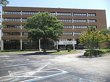
Duval County Public Schools headquarters
Duval County Public Schools operates public schools in the county.
Duval County is served by the Jacksonville Public Library.
TV channel
Duval County has its own public-access television network, known as DCPS. It is primarily used to spread news about the county's school districts.
Communities
- 842,583 - Jacksonville
- 21,823 - Jacksonville Beach
- 12,985 - Atlantic Beach
- 7,124 - Neptune Beach
- 1,430 - Baldwin
2013 estimate population[23]
Transportation
Major highways

 I-10 / SR 8
 I-95
I-95
 I-295
I-295

 US 1 / SR 5
 US 1 Alt.
 US 17
US 17
 US 23
US 23
 US 90
US 90
US 90 Alt.
 US 301
 SR A1A
 SR 9
SR 9
 SR 9A
SR 9A
 SR 9B
SR 9B
 SR 10
SR 10
Airports
- Cecil Airport
- Herlong Recreational Airport
- Jacksonville Executive at Craig Airport
- Jacksonville International Airport
See also
- National Register of Historic Places listings in Duval County, Florida
- List of tallest buildings in Jacksonville
References
^ Publications of the Florida Historical Society. Florida Historical Society. 1908. p. 31..mw-parser-output cite.citation{font-style:inherit}.mw-parser-output q{quotes:"""""""'""'"}.mw-parser-output code.cs1-code{color:inherit;background:inherit;border:inherit;padding:inherit}.mw-parser-output .cs1-lock-free a{background:url("//upload.wikimedia.org/wikipedia/commons/thumb/6/65/Lock-green.svg/9px-Lock-green.svg.png")no-repeat;background-position:right .1em center}.mw-parser-output .cs1-lock-limited a,.mw-parser-output .cs1-lock-registration a{background:url("//upload.wikimedia.org/wikipedia/commons/thumb/d/d6/Lock-gray-alt-2.svg/9px-Lock-gray-alt-2.svg.png")no-repeat;background-position:right .1em center}.mw-parser-output .cs1-lock-subscription a{background:url("//upload.wikimedia.org/wikipedia/commons/thumb/a/aa/Lock-red-alt-2.svg/9px-Lock-red-alt-2.svg.png")no-repeat;background-position:right .1em center}.mw-parser-output .cs1-subscription,.mw-parser-output .cs1-registration{color:#555}.mw-parser-output .cs1-subscription span,.mw-parser-output .cs1-registration span{border-bottom:1px dotted;cursor:help}.mw-parser-output .cs1-hidden-error{display:none;font-size:100%}.mw-parser-output .cs1-visible-error{font-size:100%}.mw-parser-output .cs1-subscription,.mw-parser-output .cs1-registration,.mw-parser-output .cs1-format{font-size:95%}.mw-parser-output .cs1-kern-left,.mw-parser-output .cs1-kern-wl-left{padding-left:0.2em}.mw-parser-output .cs1-kern-right,.mw-parser-output .cs1-kern-wl-right{padding-right:0.2em}
^ ab "American Fact Finder". United States Census Bureau. Retrieved March 24, 2018.
^ "Find a County". National Association of Counties. Archived from the original on 2012-07-12. Retrieved 2011-06-07.
^ Matt Soergel, "Archaeologists help distinguish Mocama group", Morris News Service, 25 October 2009, accessed 11 May 2010
^ Gannett, Henry (1905). The Origin of Certain Place Names in the United States. Govt. Print. Off. p. 111.
^ Fernald, Edward A., Ed. (1981) Atlas of Florida. The Florida State University Foundation, Inc.
ISBN 0-9606708-0-7 P.131
Alachua County Maps
Nassau County Maps
Clay County Maps
^ "US Gazetteer files: 2010, 2000, and 1990". United States Census Bureau. 2011-02-12. Retrieved 2011-04-23.
^ "American FactFinder". Retrieved March 24, 2018.
^ "U.S. Decennial Census". United States Census Bureau. Archived from the original on May 12, 2015. Retrieved June 13, 2014.
^ "Historical Census Browser". University of Virginia Library. Retrieved June 13, 2014.
^ "Population of Counties by Decennial Census: 1900 to 1990". United States Census Bureau. Retrieved June 13, 2014.
^ "Census 2000 PHC-T-4. Ranking Tables for Counties: 1990 and 2000" (PDF). United States Census Bureau. Retrieved June 13, 2014.
^ abcdefghi "Duval County: SELECTED SOCIAL CHARACTERISTICS IN THE UNITED STATES 2006-2010 American Community Survey 5-Year Estimates". factfinder.census.gov. Retrieved October 22, 2015.
^ abcd "Duval County Demographic Characteristics". ocala.com. Retrieved October 22, 2015.
^ "Duval County, Florida FIRST ANCESTRY REPORTED Universe: Total population - 2006-2010 American Community Survey 5-Year Estimates". factfinder.census.gov. Retrieved November 12, 2015.
^ "Duval County, Florida Hispanic or Latino by Type: 2010 -- 2010 Census Summary File 1". factfinder.census.gov. Retrieved October 22, 2015.
^ ab "Duval County: Age Groups and Sex: 2010 - 2010 Census Summary File 1". factfinder.census.gov. Retrieved October 22, 2015.
^ "Duval County, Florida: SELECTED ECONOMIC CHARACTERISTICS - 2006-2010 American Community Survey 5-Year Estimates". factfinder.census.gov. Archived from the original on November 29, 2014. Retrieved November 18, 2015.
^ "Demographics of Duval County, FL". MuniNetGuide.com. Retrieved October 22, 2015.
^ ab "Modern Language Association Data Center Results of Duval County, Florida". Modern Language Association. Retrieved October 22, 2015.
^ "Archived copy". Archived from the original on 2016-10-24. Retrieved 2016-10-27.CS1 maint: Archived copy as title (link)
^ Leip, David. "Dave Leip's Atlas of U.S. Presidential Elections". uselectionatlas.org. Retrieved 2018-06-14.
^ "Annual Estimates of the Resident Population for Incorporated Places in Florida". United States Census Bureau. Retrieved April 22, 2014.
External links
| Wikimedia Commons has media related to Duval County, Florida. |
Government links
City of Jacksonville official website of City of Jacksonville/Duval County
Elected constitutional offices
- Duval County Property Appraiser
- Duval County Supervisor of Elections
- Duval County Tax Collector
- Jacksonville Sheriff's Office
- Duval County Clerk of the Courts
Special districts
- Duval County Public Schools
- St. Johns River Water Management District
Judicial branch
- Duval County Clerk of Courts
Public Defender, 4th Judicial Circuit of Florida serving Duval, Clay, and Nassau Counties- Office of the State Attorney, 4th Judicial Circuit of Florida
- Circuit and County Court, 4th Judicial Circuit of Florida
Tourism
- Jacksonville and the Beaches Convention and Visitors' Bureau
Places adjacent to Duval County, Florida | ||||||||||
|---|---|---|---|---|---|---|---|---|---|---|
| ||||||||||
Municipalities and communities of Duval County, Florida, United States | ||
|---|---|---|
County seat: Jacksonville | ||
| Cities |
|  |
| Town |
| |
| Neighborhoods of Jacksonville |
| |
| ||
|  | |
| ||
Tallahassee (capital) | ||
| Topics |
|  Seal of Florida |
| History |
| |
| Geography |
| |
| Major hurricanes |
| |
| Society |
| |
| Regions |
| |
| Metro areas |
| |
| Largest cities |
| |
| Counties |
| |
North Florida | ||
|---|---|---|
Region of Florida | ||
| Topics |
|  Map of North Florida |
| Counties |
| |
| Major cities |
| |
| Cities and towns 100k+ |
| |
| Cities and towns 25k–100k |
| |
| Cities and towns 10k–25k |
| |
| Metro areas |
| |
| Regions |
| |
Coordinates: 30°20′N 81°39′W / 30.33°N 81.65°W / 30.33; -81.65


