Dire Dawa
Dire Dawa ድሬ ዳዋ Diri Dhabe | |
|---|---|
City | |
 Downtown Dire Dawa | |
Nickname(s): Dirah Dawah | |
 Dire Dawa Location within Ethiopia | |
Coordinates: 9°36′N 41°52′E / 9.600°N 41.867°E / 9.600; 41.867 | |
| Country | Ethiopia |
| Region | Dire Dawa |
| Zone | Dire Dawa |
| District | Dire Dawa |
| Founded | 24 December 1902 |
| Government | |
| • Type | Chartered City |
| • Mayor | Adam Farah [2] |
| Area | |
| • Total | 1,213 km2 (468 sq mi) |
| Elevation | 1,276[3] m (4,189 ft) |
| Population (2008) | |
| • Total | 440,000[1] |
| • Density | 4,530/km2 (11,700/sq mi) |
| Time zone | UTC+3 (EAT) |
| Area code(s) | (+251) 25 |
| Website | www.dire-dawa.gov.et |
Dire Dawa (Amharic: ድሬ ዳዋ, Oromo: Dirre Dhawaa, lit. "Place of Remedy",[4]Somali: Dir Dhabe, meaning "where Dir hit his spear into the ground", Arabic: ديري داوا[5][6]) is one of two chartered cities (astedader akabibi) in Ethiopia (the other being the capital, Addis Ababa). It is divided administratively into two woredas, the city proper and the non-urban woreda of Gurgura.
Dire Dawa lies in the eastern part of the nation, on the Dechatu River, at the foot of a ring of cliffs that has been described as "somewhat like a cluster of tea-leaves in the bottom of a slop-basin."[7] The western outskirts of the city lie on the Gorro River, a tributary of the Dechatu River. At a latitude and longitude of 9°36′N 41°52′E / 9.600°N 41.867°E / 9.600; 41.867Coordinates: 9°36′N 41°52′E / 9.600°N 41.867°E / 9.600; 41.867, Dire Dawa is the second largest city in Ethiopia.
The city is an industrial centre, home to several markets and the Aba Tenna Dejazmach Yilma International Airport.
Contents
1 History
1.1 Origins
1.2 1902-1936
1.3 1936-1941
1.4 1941-1974
1.5 1974-1991
1.6 1991-Present
2 Climate
3 Demographics
4 Economy
5 Transportation
6 Dire Dawa in literature
7 Chairmen of the Administrative Council
8 Notable People from Dire Dawa
9 See also
10 References
11 External links
History
Origins
The region of Dire Dawa was already populated by human beings in Mesolithic times, as revealed by rock paintings and Middle-Stone-Age artifacts in the cave of Porc-Épic, only a few kilometers from Dire Dawa.[8][9]
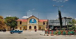
Dire Dawa Railway Station
Historically, the city of Dire Dawa was originally called Dir Dhabe and used to be part of Adal Sultanate during the medieval times and was exclusively settled by Dir clan which is a major Somali tribe and after the weakening of Adal Sultanate, the Oromos took advantage and were able to penetrate through the city and settle into these areas and also assimilate some of the local Gurgura clan.[10]

Train departing from Dire Dawa c. 1912

Panorama of Dire Dawa c. 1915
1902-1936
The present-day town of Dire Dawa ((311 km by rail from Djibouti), however, is of very recent origin. It owes its foundation to a technical problem: when it became impossible to lay the Addis Ababa-Djibouti Railway via Harar because of the steep access to the town, atse Menelik II accepted (in a later dated 5 November 1896) that the first part of the line might finish at a village at the foot of the mountains, which should be named Addis Harar ("New Harrar").[11] The railway reached this location on 24 December 1902, a date which may be considered the day of Dire Dawa's foundation. The new name, however, did not win recognition. In the long run, the local name Dire Dawa was generally accepted. Dire Dawa most probably derives from Somali Dir dabo (limit of the Dir confederation of the Somali) and popularly etymologizes in its Amharic form as "hill of uncultivated land".
For financial and diplomatic reasons the railway was not continued until 1909 and the final inauguration of the whole line from Djibouti to Addis Ababa-again delayed by the revolution of 1916-only took place on 7 Jun 1917. During all this time, Dire Dawa was practically the town profited much and became a "boom city", attracting most of the trade which formerly passed through Harar. By 1902 the Ethiopian government, anticipating the future economic importance of Dire Dawa, had already transferred the customs station for trade with the Red Sea from Gildessa to Dire Dawa.[12]
Dire Dawa developed into two settlements separated by the Dekato River, which was dry for most of the year and became a torrent only when it rained. The north-western part of the town was planned and constructed very regularly, mostly by the engineers of the railway company. At first, this part of the town mostly housed the employees of the railway company, but it later attracted, besides the French, also Greeks, Armenians, other Europeans and Arabs, who opened shops and hotels and founded some industry as well. In 1909 the French Capuchin Mission settled in Dire Dawa. At that time Dire Dawa looked like a French town.[11] The other part of the town, southeast of the river, concentrated around the market and was inhabited mainly by Ethiopian, Somali and a few Arab traders.
In September 1916 the fleeing troops of lij Iyasu took hold of the town. Though lij Iyasu's governor there, the Syrian Hasib al-Idlibi, assured their security, 400 Europeans left the town and the rail traffic had to be suspended. After the battle of Maeso, the governmental troops from Addis Ababa re-established a regular administration.[11]
During the 1920s, the south-eastern part of the town also started to develop. Its inhabitants were mostly Somali and Oromo, the other Ethiopians playing only a minor role. The population here grew to 3,000, while that of the whole town numbered 20,000. Between the two World Wars, two hospitals were established in Dire Dawa, one by the railway company and another in 1934 by the government. Education on a primary level was provided by a government school, a Catholic mission school and several schools for the different foreign communities in the town (Greek, Italian, Indian).[12]

Dire Dawa 1934
Dire Dawa's first governor was Ato Mersha Nahusenay, who was also instrumental in the construction of the first railway.[13][14] The imperial railway company (Cie) played a key role in the early development of the city, particularly Gezira (aka Kezira), under the authority of the Ethiopian government. The original failed company was reörganized as the joint-government Franco-Ethiopian Railway in 1908 and, after a period of financial negotiation and recapitalization, construction began anew, linking the city with the Ethiopian capital Addis Ababa in 1917. The Dire Dawa-Harar road was improved in 1928, shortening the travel time to only a few hours.[15] In 1931, the Bank of Ethiopia opened its first branch in the city[16] and, a generation later, the writer C.F. Rey described the city as the most "advanced" urban center in the area, with good roads, electric lights, and piped water.[17]
1936-1941
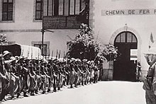
Italian troops taking possession of the Dire Dawa railway station in 1936
On 9 May 1936 Dire Dawa was occupied by Italian troops coming from Harar, after Somali troops from Djibouti had prevented looting during the period of interregnum. Badoglio and Graziani celebrated their meeting on the railway station of Dire Dawa. The Italians constructed several new buildings in Dire Dawa, especially for the administration and the Fascist party. They also improved the roads and enlarged the airport so that their military planes could take off from there to bomb the patriot forces in the Gara Mulleta.[18] As for other towns, the Italians conceived a "piano regolatore" for the construction of an Italian town in Dire Dawa. However, their occupation ended before they could complete these plans.
During the Italian invasion, Mussolini ordered that Addis Ababa and Dire Dawa be spared air attacks (which included the use of chemical weapons such as mustard gas) and other destruction as a response to the demands of the United States and certain European countries for the safety of their citizens. The Italian army entered the country from the colonies of Eritrea in the north and Somalia in the southeast. Following all major engagements of the war, Dire Dawa was the location of the meeting of the two Italian forces. General Graziani's units, advancing from Harar, reached the city's barbed-wire fence on 6 May 1936, the day after the occupation of Addis Ababa and Emperor Haile Selassie's flight along the railroad to Djibouti and Palestine. They were met by two French armed cars: the railway remained under French administration and they had remained to protect the French interests. The next day, the first train under Italian control left Addis Ababa: it brought Italy's 46th Infantry Regiment and finally closed the pincers of the two Italian invasion forces. The occupation of the town was more or less a formality,[16] although resistance fighters known as Arbegnoch ("Patriots") continued to operate throughout the conflict. It was officially known by its Italian spelling Dire Daua during the occupation.
1941-1974
In June 1940 the British started to bomb the town and on 29 March 1941 Dire Dawa was liberated by the Allied forces from Harar. The town remained under British Military Administration, being the headquarters for the British Reserved Areas (Ogaden), till it was handed over to the Ethiopian government in 1947. In the following decades the town greatly expanded and the population grew to 160,000. The infrastructure was ameliorated and several industrial plants were established.[12]
Following the restoration of the empire in 1941, Dire Dawa was among the early provincial towns to have its own soccer league. Around 1947, their team—the Taffari—participated in the Ethiopian Championship series. That same year, the Railroad Workers Syndicate of Dire Dawa, a labor union, was formed for welfare purposes.[16] Although its leadership coöperated with the government, its attempt to strike in 1949 was brutally suppressed by imperial troops; at the time, all strikes were seen as forms of insurrection or treason.[19] In 1955, a public address system was installed in the central square to receive and rebroadcast state radio transmissions.[16]
1974-1991
The Ethiopian revolution affected the city in many ways. Starting March 1974, there was some worker unrest; six people were wounded when police opened fire on demonstrating railwaymen and students on 17 April. Many Europeans, Yemeni Arabs, and Indians left Dire Dawa; the Greek and Armenian churches were eventually closed due to dwindling membership. On 3 February 1975, the Derg announced that the Cotton Company of Ethiopia was among 14 textile enterprises to be fully nationalized. The cement factory was also later nationalized. In August 1976, the entire leadership of the local branch of the teachers' union was sacked for alleged anti-revolutionary activities. Ten new officials were appointed pending fresh elections.[16]
Dire Dawa again played a role in the Ethio-Somali War of 1977/78. It was besieged by the Somali troops till November 1977, when the Ethiopians, Cubans and Russians under General Vasiliy Petrov took the offensive and pushed the Somalis back. In May 1979, 250 Oromos who were detained in the prisons of Dire Dawa were executed by the Derg regime.[20] According to Gebru Tareke, the success of the Ethiopian Army in holding Dire Dawa (17–18 August 1977) against the Somali Army was decisive in winning the Ogaden War.[21] The war led to widespread dislocation of Ethiopia's native Somali population and subsequent repopulation from other areas of the country greatly decreased their importance around Dire Dawa.
1991-Present
Dire Dawa was occupied by the EPRDF on 31 May 1991. There were reports of about 100 people killed resisting the EPRDF. In 1991, when the Somali National Movement took control of northern Somalia, they dismantled and sold the only publicly owned industry in the whole Somali northern region, a cement factory near Berbera, which was shipped off to help expand the cement factory in Dire Dawa.[16] Both the Issa and Gurgura Liberation Front and the Oromo Liberation Front claimed the city. As a result, there were numerous clashes between the two groups from 1991 until 1993. When the Somali Regional State was being established in 1993, it wanted Dire Dawa to be its capital. This was opposed by the Oromia Region, so the federal government placed the city under its own jurisdiction to avoid territorial conflict between the two regions.[22]
On 24 June 2002, a small explosive was detonated at the headquarters of the Ethiopian Railway Commission in Dire Dawa. The Oromo Liberation Front afterwards claimed responsibility for this attack in retaliation "for the continuing harassment of Oromo students, merchants, and farmers by the Ethiopian government." Although blamed for other isolated incidents, this was the latest bombing inside Ethiopia for which the OLF claimed responsibility.[23]
Dire Dawa moved out of federal administration to become a chartered city in 2004 after the federal parliament approved the city charter in proclamation 416/2004.[22]
The city was flooded in August 2006 when both the Dechatu River and the Gorro River overflowed their banks. About 200 people were reported dead, thousands were displaced and there was extensive damage to homes and markets especially along the Dechatu River. Floods are fairly common during the June–September rainy season; over 200 people in the region had been killed by flooding in 2005 that did millions of dollars in damage.[24]
An overturned truck, heading from Dengego to Dire Dawa, killed 41 people 4 March 2009. The truck was carrying an unknown number of day laborers when the accident happened, and 38 were immediately killed and as many as 50 were injured. Dead and injured were taken to Dil-chora Hospital in Dire Dawa. The cause was not immediately known.[25]
Currently, there are plans to revitalize the city. A historic and popular part of the city is to be demolished and replaced by a financial center, malls, mixed-use buildings, hotels, recreational facilities, and hospitals. As part of the plan, historical buildings will be renovated, and a new space will be allotted for building new homes and businesses for those displaced by the move. New roads, parks, and an industrial zone will also be built, and major railway project is expected to greatly increase business activity in the city.[26][27]
Climate
Dire Dawa has a hot semi-arid climate (Köppen climate classification BSh). The mean annual temperature of Dire Dawa is about 25.9 °C or 78.6 °F. The average maximum temperature of Dire Dawa is 32.8 °C or 91.0 °F, while its average minimum temperature is about 19.0 °C or 66.2 °F. The region has two rain seasons; that is, a small rain season from March to April, and a more pronounced rain season that extends from July to August. The aggregate average annual rainfall that the region gets from these two seasons is about 583 millimetres or 23.0 inches.
| Climate data for Dire Dawa | |||||||||||||
|---|---|---|---|---|---|---|---|---|---|---|---|---|---|
| Month | Jan | Feb | Mar | Apr | May | Jun | Jul | Aug | Sep | Oct | Nov | Dec | Year |
| Average high °C (°F) | 29.4 (84.9) | 31.5 (88.7) | 34.1 (93.4) | 32.7 (90.9) | 34.8 (94.6) | 35.9 (96.6) | 34.3 (93.7) | 32.9 (91.2) | 33.6 (92.5) | 33.6 (92.5) | 31.6 (88.9) | 29.6 (85.3) | 32.8 (91.1) |
| Daily mean °C (°F) | 22.0 (71.6) | 24.1 (75.4) | 26.6 (79.9) | 26.5 (79.7) | 28.4 (83.1) | 29.5 (85.1) | 27.9 (82.2) | 26.5 (79.7) | 27.1 (80.8) | 26.2 (79.2) | 24.0 (75.2) | 22.1 (71.8) | 25.9 (78.6) |
| Average low °C (°F) | 15.5 (59.9) | 16.6 (61.9) | 19.1 (66.4) | 20.4 (68.7) | 22.3 (72.1) | 22.8 (73) | 21.2 (70.2) | 20.2 (68.4) | 20.7 (69.3) | 18.7 (65.7) | 15.9 (60.6) | 15.0 (59) | 19 (66.3) |
| Average rainfall mm (inches) | 16.6 (0.654) | 55.2 (2.173) | 61.6 (2.425) | 74.8 (2.945) | 45.5 (1.791) | 15.6 (0.614) | 83.9 (3.303) | 87.7 (3.453) | 39.8 (1.567) | 24.8 (0.976) | 59.9 (2.358) | 17.8 (0.701) | 583.2 (22.96) |
| Average relative humidity (%) | 43.9 | 49.8 | 45.0 | 47.0 | 39.3 | 37.6 | 41.4 | 45.1 | 39.7 | 31.3 | 39.1 | 42.6 | 41.8 |
| Mean monthly sunshine hours | 294.5 | 265.6 | 257.3 | 246.0 | 244.9 | 204.0 | 220.1 | 244.9 | 234.0 | 248.0 | 282.0 | 300.7 | 3,042 |
| Mean daily sunshine hours | 9.5 | 9.4 | 8.3 | 8.2 | 7.9 | 6.8 | 7.1 | 7.9 | 7.8 | 8.0 | 9.4 | 9.7 | 8.3 |
| Source #1: Normales et records pour la période 2000-2016 à Dire Dawa ,[28] | |||||||||||||
| Source #2: Klimatafel von Dire Dawa (Diredaua), Provinz Harar / Äthiopien for sunshine hours,[29] | |||||||||||||
Demographics
Ethnic groups of Dire Dawa
Oromo (45%)
Somali (35%)
Amhara (13%)
Gurage (3%)
Harari (1%)
Other (3%)
Censuses record that Oromo are the greatest percentage of the city, based on the number who claim Oromo identity and speak the Oromo language. Traditionally the Nole Oromo clan used the area as grazing land, and farming in the Laga Harre district. They live alongside the Gurgura clan which share both Oromo and Somali identities, speaking the Oromo language and tracing their genealogy to the Dir, a Somali clan family.[22] The Issa subclan of the Dir make up a huge number of urban and rural Dire Dawa, whereas a small fraction of the Gadabuursi subclan of the Dir mainly reside in the rural areas to the east of the chartered city state [30][31]
Based on the 2007 Census conducted by the Central Statistical Agency of Ethiopia (CSA), Dire Dawa has a population of 341,834, of whom 171,461 are men and 170,461 women; 233,224 or 68.23% of the population are urban inhabitants. For all of Dire Dawa 76,815 households were counted living in 72,937 housing units, which results in an average of 4.5 persons to a household, with urban households having on average 4.2 and rural households 4.9 people. Ethnic groups in the region include the Oromo (45%), Somali (35%), Amhara (13%), Gurage (3%), and Harari (1%). The religion with the most believers in Dire Dawa is Muslim with 70.8%, 25.71% are Ethiopian Orthodox, 2.81% Protestant, and 0.43% Catholic.[32]

A map of the regions and zones of Ethiopia
According to the CSA, as of 2004[update], 90.76% of the population had safe drinking water: 69.61% of rural and 99.48% of urban inhabitants having access.[33] Values for other reported common indicators of the standard of living for Dire Dawa as of 2005[update] include the following: 11.4% of the inhabitants fall into the lowest wealth quintile; adult literacy for men is 76.6% and for women 53%; and the civic infant mortality rate is 71 infant deaths per 1,000 live births, which is less than the nationwide average of 77; at least half of these deaths occurred in the infants’ first month of life.[34]
Economy
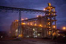
The National Cement Share Company of Ethiopia's new plant in Dire Dawa
Dire Dawa received postal service in August 1906, becoming the third location after Addis Ababa and Harar. Telephone service was available by 1954; by 1967, Dire Dawa had almost 500 telephone numbers, more than almost all other towns including Gondar, Harar, and Jimma.[16]

Gas station in Dire Dawa
The CSA estimated in 2005 that farmers in Dire Dawa had a total 40,400 head of cattle (representing 0.1% of Ethiopia's total), 46,280 sheep (0.27%), 118,770 goats (0.92%), 8,820 asses (0.35%), 5,070 camels (1.11%), 44,740 poultry of all species (0.14%), and 840 beehives (less than 0.1%).[35]
The invasive weed Parthenium hysterophorus (or Congress weed) was first observed in Ethiopia near Dire Dawa in 1980. Experts speculate that it entered the country either through the Djibouti - Addis Ababa railway line or the international airport, carried by one of the food aid programs.[36]
About 2007, a concrete sleeper factory was established, sited near the cement factory.
Dire Dawa is home to several market centers, the biggest being Taiwan along with Qefira which is on the flood plain. Near Dire Dawa and what is now Kebele 01, trading happened in the town called Melka Jebdu. It has been the gateway for most of the goods sold in places such as Taiwan.
Transportation

Taxicab stand in Dire Dawa
Dire Dawa is served by a station on the Addis Ababa–Djibouti Railway, which is located 10 km northwest of the city centre close to the town of Melka Jebdu. In addition, the city is served by the Ethio-Djibouti Railways with its western terminus located in the city centre. The Dire Dawa Airport offers flights to and from the city. Additionally, the Selam Bus Line Share Company provides inter-city bus service.
Dire Dawa in literature
Dire Dawa was the inspiration for the fictional town "Debra Dowa", capital of the fictional East African nation "Azania" in the "outrageously un-politically correct tale"[37]Black Mischief by the English author, Evelyn Waugh.
Chairmen of the Administrative Council
Habtamu Assefa Wakjira 1991 - 1993
Ismail Aw Aden 1993 - 1995
Solomon Hailu 1995 - 2003
Fisseha Zerihun 2003 - 2006
Abdulaziz Mohammed 7 August 2006 - 2008
Adem Farah June 2008 - 2010
Asad Ziad June 2010 – 2015
Ibrahim Uthman June 2015 - present
(This list is based on information from Worldstatesman.org.)
Notable People from Dire Dawa
- Ali Birra
- Uggas Buhe Gedid
- Ismail Omar Guelleh
- Ato Hussein Ismail
- Tari Liban
- Luciano Violante
See also
| Wikimedia Commons has media related to Dire Dawa. |
- Railway stations in Ethiopia
- Cement in Africa
References
^ http://www.citypopulation.de/Ethiopia.html
^ http://www.diretube.com/dire-dawa-tv/dire-dawa-mayor-adem-farah-wishing-happy-new-year-video_1f12c85fa.html
^ http://www.fallingrain.com/world/ET/48/Dire_Dawa.html
^ Kefale, Asnake. "Ethnic Federalism and Conflict Management in Ethiopia: The Case of Dire Dawa" in Luc Sindjoun (ed.)'s The Coming African Hour: Dialectics of Opportunities and Constraints, p. 209. Africa Institute of South Africa (Pretoria), 2010. Accessed 15 Feb 2014.
^ Referencing Dir confederation of Somali clans which inhabit vast area between the Red Sea and Dir Dawa. See Dir.
^ academies, prepared by a number of leading orientalists ; edited by an editorial committee consisting of H.A.R. Gibb ... [et al.] ; under patronage of the international union of (2009). Encyclopaedia of islam (New ed.). Leiden: E.J. Brill. ISBN 9789004161214..mw-parser-output cite.citation{font-style:inherit}.mw-parser-output q{quotes:"""""""'""'"}.mw-parser-output code.cs1-code{color:inherit;background:inherit;border:inherit;padding:inherit}.mw-parser-output .cs1-lock-free a{background:url("//upload.wikimedia.org/wikipedia/commons/thumb/6/65/Lock-green.svg/9px-Lock-green.svg.png")no-repeat;background-position:right .1em center}.mw-parser-output .cs1-lock-limited a,.mw-parser-output .cs1-lock-registration a{background:url("//upload.wikimedia.org/wikipedia/commons/thumb/d/d6/Lock-gray-alt-2.svg/9px-Lock-gray-alt-2.svg.png")no-repeat;background-position:right .1em center}.mw-parser-output .cs1-lock-subscription a{background:url("//upload.wikimedia.org/wikipedia/commons/thumb/a/aa/Lock-red-alt-2.svg/9px-Lock-red-alt-2.svg.png")no-repeat;background-position:right .1em center}.mw-parser-output .cs1-subscription,.mw-parser-output .cs1-registration{color:#555}.mw-parser-output .cs1-subscription span,.mw-parser-output .cs1-registration span{border-bottom:1px dotted;cursor:help}.mw-parser-output .cs1-hidden-error{display:none;font-size:100%}.mw-parser-output .cs1-visible-error{font-size:100%}.mw-parser-output .cs1-subscription,.mw-parser-output .cs1-registration,.mw-parser-output .cs1-format{font-size:95%}.mw-parser-output .cs1-kern-left,.mw-parser-output .cs1-kern-wl-left{padding-left:0.2em}.mw-parser-output .cs1-kern-right,.mw-parser-output .cs1-kern-wl-right{padding-right:0.2em}
^ C.F. Beckham and G.W.B. Huntingford, Some Records of Ethiopia, 1593-1646 (London: Hakluyt Society, 1954), p. 224 n.1.
^ Perlès, Catherine (1974). "Réexamen typologique de l'industrie du Porc Épic (Éthiopie): les pointes et pièces pointues". L'Archéologie. 78: 529–552.
^ Clark, John; Williams, Kenneth; Michaels, Joseph; Marean, Curtis (1984). "A Middle Stone Age Occupation Site at Porc Epic at Dire Dawa (East-Central Ethiopia)". African Archaeological Review. 2: 37–71.
^ ʻArabfaqīh, Shihāb al-Dīn Aḥmad ibn ʻAbd al-Qādir (2003-01-01). The conquest of Abyssinia: 16th century. Annotation: Dir, According to Huntingford a settlement which may be modern Dire Dawa. Tsehai Publishers & Distributors. p. 24.
^ abc van Gelder de Pineda, Rosanna (1995). Le chemin de fer de Djibouti à Addis-Abeba. Paris: Harmattan. pp. 268–271.
^ abc Pankhurst, Richard (1985). History of Ethiopian Towns: from the Mid-Nineteenth Century to 1935. Stuttgart. pp. 271–274.
^ Pankhurst (2010).
^ Bekele, Shiferaw (1989).
^ Pankhurst, Richard R.K. An Economic History of Ethiopia, pp. 289–290. Haile Selassie University Press (Addis Ababa), 1968.
^ abcdefg Nordic Africa Institute. "Local History in Ethiopia Archived 2008-05-28 at the Wayback Machine.". Accessed 1 Mar 2008.
^ Cited in Pankhurst (1968), p. 620.
^ Brotto, Enrico (1938). "Dire Daua". Rivista delle Colonie. 12: 37–44.
^ Keller, Edmund J. Revolutionary Ethiopia, p. 147. Indiana University Press (Bloomington, 1988.
^ Wagner, Ewald (2005). "History of Dire Dawa". In Uhlig, Siegbert. Encylopaedia Aethiopica. 2. Wiesbaden: Harrassowitz.|access-date=requires|url=(help)
^ Tareke, Gebru. "The Ethiopia-Somalia War of 1977 Revisited Archived 2013-12-07 at the Wayback Machine." in the International Journal of African Historical Studies, Vol. 33, No. 3 (2000), pp. 645–7. Accessed 13 May 2009.
^ abc Asnake Kefale (2014). "Ethnic decentralization and the challenges of inclusive governance in multiethnic cities: The case of Dire Dawa, Ethiopia". Regional & Federal Studies. 24 (5): 589–605. doi:10.1080/13597566.2014.971772.
^ MIPT Terrorism Knowledge Base "Oromo Liberation Front (OLF) attacked Government target (June 24, 2002, Ethiopia)", last accessed 22 April 2006.
^ Scores killed in Ethiopia floods, BBC News, 6 August 2006
^ "Death toll for recent road accident reaches 41: Police"[permanent dead link]Ethiopian News Agency website, dated 5 March 2009 (accessed 14 April 2009)
^ http://addisababaonline.com/dire-is-booming-but-landmark-get-the-axe/
^ http://www.ena.gov.et/en/index.php/economy/item/804-industrial-park-to-be-constructed-in-adama-dire-dawa-cities
^ "Normales et records pour la période 2000-2016 à Dire Dawa". Infoclimat. Retrieved 2014-01-13.
^ "Klimatafel von Dire Dawa (Diredaua), Provinz Harar / Äthiopien" (PDF). climatestotravel.com. Retrieved 2014-01-13.
^ Cite error: The named reference:3was invoked but never defined (see the help page).
^ Lewis, I. M. (1998-01-01). Saints and Somalis: Popular Islam in a Clan-based Society. The Red Sea Press. p. 100. ISBN 9781569021033.
^ Census 2007 Tables: Dire Dawa Archived 2010-11-14 at the Wayback Machine., Tables 2.1, 2.5, 3.1, 3.2 and 3.4
^ "Households by sources of drinking water, safe water sources" Archived March 5, 2009, at the Wayback Machine. CSA Selected Basic Welfare Indicators (accessed 28 January 2009)
^ Macro International Inc. "2008. Ethiopia Atlas of Key Demographic and Health Indicators, 2005." (Calverton: Macro International, 2008), pp. 2, 3, 10 (accessed 28 January 2009)
^ "CSA 2005 National Statistics" Archived November 18, 2008, at the Wayback Machine., Tables D.4 - D.7.
^ Rezene Fessehaie1, Mekasha Chichayibelu1, and Mengistu Haile Giorgis, "Spread and Ecological Consequences of Parthenium hysterophorus in Ethiopia"[permanent dead link], Arem. 6 (2005): 11-21 (accessed 30 April 2009)
^ "Good Reads" [1]
- Bekele, Shiferaw (1989). Aspects of the History of Dire Dawa (1902-1936)
- Imbert-Vier, S. (2011). Tracer des frontières à Djibouti: Des territoires et des hommes aux XIXe et XXe siècles; p. 116
- Pankhurst, R. (2010). Who were the 'Young Ethiopians' (or Young Abyssinians): An historical inquiry. Education Issue, Vol. 2, no.2, p: 129
External links
| Wikivoyage has a travel guide for Dire Dawa. |
- Official website
| Regions |
|
|---|---|
| Chartered cities |
|
| Provinces '"`UNIQ--templatestyles-0000004B-QINU`"' (prior to 1995) |
|


