Wills Creek (North Branch Potomac River tributary)

Wills Creek near its mouth in Cumberland in 2007
Wills Creek is a 38.6-mile-long (62.1 km)[1]tributary of the North Branch Potomac River in Pennsylvania and Maryland in the United States.
Wills Creek drops off the Allegheny Mountains of southeastern Somerset County, Pennsylvania, and enters the North Branch Potomac River at Cumberland, Maryland.
Contents
1 Tributaries
2 History
3 Cumberland flood control system
4 See also
5 References
6 External links
Tributaries
- Brush Creek (Wills Creek)
- Little Wills Creek
History
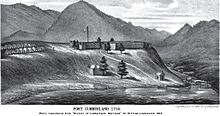
Fort Cumberland, 1755
Wills Creek was named after Will's Town, a former settlement of the Shawnee Indians at the site of Cumberland, Maryland.[2] After the Shawnee deserted this region, an Indian named Will lived a short distance from the site of the old Shawnee town at the mouth of Caiuctucuc Cr. At the time of the coming of the first white settlers he was living in a cabin on the mountain side. The creek, mountain, and town were afterward named for him. "Will's creek" is noted on the maps of Lewis Evans (1755) and Scull (1759, 1770), and on the map in Christopher Gist's journal. (See Hodge, 1912)
Cumberland flood control system
In the 1950s, the city of Cumberland and the United States Army Corps of Engineers embarked upon an $18.5 million flood-control program along a stretch of Wills Creek bordering the city. The project was one of the most costly public works projects in the city's history. Disastrous floods from Wills Creek had ravaged Cumberland, particularly in 1924, 1936, and 1942, and the Army Corp of Engineers designed a system that would prevent property damage caused by the high waters. It began just upstream from the bridge at U.S. Route 40, where the corps paved the bottom of Wills Creek, constructing concrete walls along its banks, and with the building of a sophisticated pumping system to prevent the watershed from flooding during heavy rain. The work took a decade to complete and was finished in 1959. It has successfully prevented flooding ever since.
See also
- List of rivers of Maryland
- List of rivers of Pennsylvania
- Fort Cumberland (Maryland)
- Wills Creek Formation
References
^ U.S. Geological Survey. National Hydrography Dataset high-resolution flowline data. The National Map, accessed August 15, 2011
^ "Shawnee Indian Tribe History". Access Genealogy. Retrieved 2013-02-18..mw-parser-output cite.citation{font-style:inherit}.mw-parser-output q{quotes:"""""""'""'"}.mw-parser-output code.cs1-code{color:inherit;background:inherit;border:inherit;padding:inherit}.mw-parser-output .cs1-lock-free a{background:url("//upload.wikimedia.org/wikipedia/commons/thumb/6/65/Lock-green.svg/9px-Lock-green.svg.png")no-repeat;background-position:right .1em center}.mw-parser-output .cs1-lock-limited a,.mw-parser-output .cs1-lock-registration a{background:url("//upload.wikimedia.org/wikipedia/commons/thumb/d/d6/Lock-gray-alt-2.svg/9px-Lock-gray-alt-2.svg.png")no-repeat;background-position:right .1em center}.mw-parser-output .cs1-lock-subscription a{background:url("//upload.wikimedia.org/wikipedia/commons/thumb/a/aa/Lock-red-alt-2.svg/9px-Lock-red-alt-2.svg.png")no-repeat;background-position:right .1em center}.mw-parser-output .cs1-subscription,.mw-parser-output .cs1-registration{color:#555}.mw-parser-output .cs1-subscription span,.mw-parser-output .cs1-registration span{border-bottom:1px dotted;cursor:help}.mw-parser-output .cs1-hidden-error{display:none;font-size:100%}.mw-parser-output .cs1-visible-error{font-size:100%}.mw-parser-output .cs1-subscription,.mw-parser-output .cs1-registration,.mw-parser-output .cs1-format{font-size:95%}.mw-parser-output .cs1-kern-left,.mw-parser-output .cs1-kern-wl-left{padding-left:0.2em}.mw-parser-output .cs1-kern-right,.mw-parser-output .cs1-kern-wl-right{padding-right:0.2em}
- Frederick Webb Hodge, "Handbook of American Indians North of Mexico", Copyright 1912, Vol 4. Page 956
External links
- U.S. Geological Survey: PA stream gaging stations
Coordinates: 39°39′36″N 78°46′39″W / 39.66000°N 78.77750°W / 39.66000; -78.77750


