Ostrołęka County
Ostrołęka County Powiat ostrołęcki | |
|---|---|
| County | |
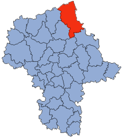 Location within the voivodeship | |
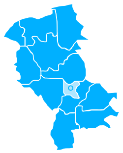 Division into gminas | |
| Coordinates (Ostrołęka): 53°4′N 21°34′E / 53.067°N 21.567°E / 53.067; 21.567Coordinates: 53°4′N 21°34′E / 53.067°N 21.567°E / 53.067; 21.567 | |
| Country | |
| Voivodeship | Masovian |
| Seat | Ostrołęka |
| Gminas | Total 11
|
| Area | |
| • Total | 2,099.32 km2 (810.55 sq mi) |
| Population (2006) | |
| • Total | 84,344 |
| • Density | 40/km2 (100/sq mi) |
| • Urban | 3,014 |
| • Rural | 81,330 |
| Car plates | WOS |
| Website | http://www.powiat.ostroleka.pl |
Ostrołęka County (Polish: powiat ostrołęcki) is a unit of territorial administration and local government (powiat) in Masovian Voivodeship, east-central Poland. It came into being on January 1, 1999, as a result of the Polish local government reforms passed in 1998. Its administrative seat is the city of Ostrołęka, although the city is not part of the county (it constitutes a separate city county). The only town in Ostrołęka County is Myszyniec, which lies 38 km (24 mi) north of Ostrołęka.
The county covers an area of 2,099.32 square kilometres (810.6 sq mi). As of 2006 its total population is 84,344, out of which the population of Myszyniec is 3,014 and the rural population is 81,330.
Neighbouring counties
Apart from the city of Ostrołęka, Ostrołęka County is also bordered by Pisz County and Kolno County to the north, Łomża County to the east, Ostrów Mazowiecka County to the south-east, Wyszków County to the south, Maków County to the south-west, Przasnysz County to the west, and Szczytno County to the north-west.
Administrative division
The county is subdivided into 11 gminas (one urban-rural and 10 rural). These are listed in the following table, in descending order of population.
Gmina | Type | Area (km²) | Population (2006) | Seat |
Gmina Kadzidło | rural | 258.9 | 11,030 | Kadzidło |
Gmina Myszyniec | urban-rural | 228.6 | 10,182 | Myszyniec |
Gmina Olszewo-Borki | rural | 195.8 | 9,505 | Olszewo-Borki |
Gmina Rzekuń | rural | 135.5 | 9,080 | Rzekuń |
Gmina Goworowo | rural | 218.9 | 8,756 | Goworowo |
Gmina Lelis | rural | 197.0 | 8,364 | Lelis |
Gmina Łyse | rural | 246.5 | 7,908 | Łyse |
Gmina Baranowo | rural | 198.2 | 6,754 | Baranowo |
Gmina Czerwin | rural | 171.1 | 5,265 | Czerwin |
Gmina Troszyn | rural | 156.3 | 4,880 | Troszyn |
Gmina Czarnia | rural | 92.5 | 2,620 | Czarnia |
References
- Polish official population figures 2006
Counties of Masovian Voivodeship | ||
|---|---|---|
| City counties |
|  |
| Land counties |
| |


