Hunter Region
Hunter Region New South Wales | |||||||||||||||
|---|---|---|---|---|---|---|---|---|---|---|---|---|---|---|---|
 View across the Hunter Valley | |||||||||||||||
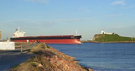 The mouth of the Hunter River at Newcastle | |||||||||||||||
 Hunter Region The location of Newcastle, the major city in the Hunter Region | |||||||||||||||
| Coordinates | 32°55′S 151°45′E / 32.917°S 151.750°E / -32.917; 151.750Coordinates: 32°55′S 151°45′E / 32.917°S 151.750°E / -32.917; 151.750 | ||||||||||||||
| Population | 620,530 (2011 census)[Note 1] | ||||||||||||||
| • Density | 21.2911/km2 (55.1438/sq mi) | ||||||||||||||
| Area | 29,145 km2 (11,252.9 sq mi) | ||||||||||||||
| Time zone | AEST (UTC+10) | ||||||||||||||
| • Summer (DST) | AEDT (UTC+11) | ||||||||||||||
| Location | 120 km (75 mi) N of Sydney | ||||||||||||||
| LGA(s) |
| ||||||||||||||
| State electorate(s) |
| ||||||||||||||
| Federal Division(s) |
| ||||||||||||||
| |||||||||||||||
The Hunter Region, also commonly known as the Hunter Valley, is a region of New South Wales, Australia, extending from approximately 120 km (75 mi) to 310 km (193 mi) north of Sydney. It contains the Hunter River and its tributaries with highland areas to the north and south.[1] The Hunter Valley is one of the largest river valleys on the NSW coast, and is most commonly known for its wineries and coal industry.
Most of the population of the Hunter Region lives within 25 km (16 mi) of the coast, with 55% of the entire population living in the cities of Newcastle and Lake Macquarie. There are numerous other towns and villages scattered across the region in the eleven local government areas (LGAs) that make up the region. At the 2011 census the combined population of the region was 620,530.
Contents
1 Geography
1.1 Rivers
1.2 Water supply
1.3 Towns and cities
2 Industries
2.1 Coal mining
2.2 Electricity generation
2.3 Horse breeding
2.4 Tourism
2.5 Wine production
3 Administration
3.1 Political representation
3.2 Demography and area
3.3 Environmental protection
4 See also
5 Notes
6 References
7 External links
Geography
Rivers
The main river in the region is the Hunter River, after which the region is named. Other rivers in the region include the Allyn, Avon, Barrington, Bow, Bowman, Chichester, Gloucester, Goulburn, Isis, Karuah, Krui, Mammy Johnsons, Merriwa, Munmurra, Pages, Paterson, Wangat and Williams rivers.
Water supply
Fresh water supply for the region is provided from a number of sources, which are managed by the Hunter Water and State Water Corporations.[2] State Water Corporation's dams supply water for irrigation, industrial use at coal mines and the region's coal-fired power stations and town water to upper Hunter Region towns. Hunter Water Corporation's dams supply the large urban population of more than 500,000 living near the coast and centered on the cities of Newcastle and Lake Macquarie.
State Water Corporation's Glenbawn, the largest dam in the region, Chichester and Lostock are dams on the Hunter, Chichester and Paterson rivers respectively. Hunter Water Corporation's Grahamstown Dam, the largest dam supplying the urban areas of the lower Hunter Region, is supplied with water diverted from the Williams River just north of the Seaham Weir, through a large pump station at Balickera. The dam itself has only a small natural catchment and relies mainly on the pumped water from the Williams River.[2] A proposal to build Tillegra Dam on the Williams River existed since the 1950s, but was scrapped in 2010.[2][3] In addition to the dams, fresh water for the lower Hunter Region is supplied from the Tomago Sandbeds, via a series of bores.
Towns and cities
The Hunter Region includes four cities. In order of population these are Lake Macquarie, Newcastle, Maitland and Cessnock. Newcastle, situated at the mouth of the Hunter River, is the second largest city in the region, although its immediate metropolitan area includes Lake Macquarie, and its statistical division also includes parts of the Maitland, Cessnock and Port Stephens areas. Other major centres of the Hunter Region are Dungog, Gloucester, Kurri Kurri, Muswellbrook, Raymond Terrace, Scone and Singleton.
Industries
The main industries in the Hunter Region are coal mining, manufacturing, agriculture, viticulture and wine making, tourism, horse breeding, electricity production, dairy farming and beef cattle farming, and associated service industries. The Hunter Region is one of Australia's most famous wine-growing regions, known for both its red and white wine varieties.
Coal mining
The most important economic activity in the valley is coal mining (through businesses such as Rio Tinto and BHP Billiton), mostly for export. The port at Newcastle is the world's largest export facility for coal, most of which is brought to the port via railway. Coal ships are often seen off the coast of Newcastle.
Electricity generation
Electricity generation at the Eraring, Bayswater, Liddell, Munmorah, Redbank and Vales Point coal-fired power stations is a major industry of the region.
Horse breeding
The Hunter Valley is Australia's main region for the breeding and rearing of Thoroughbred horses and most of the country's best racehorses.[4][5] The Upper Hunter area around Scone is one of the largest horse breeding areas in the world.
Tourism
The Hunter Valley is a major tourist destination in New South Wales and is the 6th most visited place in Australia attracting more than 2.5 million people annually. There are regular events held in the Hunter for visitors, including the Hunter Valley Steam Trains running the first three Sundays of each month and regular scenic cruises on the Hunter River and Lake Macquarie.[6][7]
Wine production

A Hunter Valley vineyard
Pokolbin is the centre of the Hunter Valley wine country, which claims to be Australia's oldest wine region.[8] It is located between the towns of Cessnock and Branxton, about 50 km (31 mi) west of Newcastle. The wine country is primarily located within the Cessnock and Singleton LGAs. Its proximity to Sydney has been an influence on the area's investments in wine production and its emergence as a tourist destination. Much of the rolling countryside around Pokolbin is under vine with the traditional varieties Shiraz and Semillon as well as extensive plantings of Chardonnay, Cabernet Sauvignon and small quantities of Pinot noir. The Pokolbin area has a large number of vineyards, restaurants, shops, golf courses and country guesthouses. Other parts of the valley including the Wollombi Valley and Broke Fordwich subregion are also well known for wine, along with the Upper Hunter Valley.
Administration
Political representation
For the purposes of Australian federal elections for the House of Representatives, the Hunter Region is contained within the divisions of Charlton,[9]Hunter,[10]Lyne,[11]Newcastle,[12]Paterson,[13] and Shortland.[14]
For the purposes of New South Wales elections for the Legislative Assembly, the Hunter Region is contained within the electoral districts of Cessnock,[15]Charlestown,[16]Lake Macquarie,[17]Maitland,[18]Myall Lakes,[19]Newcastle,[20]Port Stephens,[21]Swansea,[22]Upper Hunter,[23]Wallsend,[24] and Wyong.[25]
Demography and area
The following local government areas are contained within the region:
| Hunter rank | Local Government Area | Population 30 June 2016[26] | 10 year growth rate | Population density (people/km2) |
|---|---|---|---|---|
| 1 | City of Lake Macquarie | 202,847 | 7.6 | 312.7 |
| 2 | City of Newcastle | 160,919 | 9.8 | 861.7 |
| 3 | City of Maitland | 79,340 | 24.9 | 202.7 |
| 4 | Port Stephens Council | 71,118 | 14.5 | 82.8 |
| 5 | City of Cessnock | 56,762 | 19.7 | 28.9 |
| 6 | Singleton Council | 23,595 | 4.7 | 4.8 |
| 7 | Muswellbrook Shire | 16,468 | 5.3 | 4.8 |
| 8 | Upper Hunter Shire | 14,409 | 8.1 | 1.8 |
| 9 | Dungog Shire | 9,114 | 10.5 | 4.1 |
| Hunter | 634,572 | 11.7 | 28.0 | |
Environmental protection
The Hunter Region contains the Goulburn River National Park, Myall Lakes National Park, Barrington Tops National Park, Werakata National Park, Watagans National Park, Mount Royal National Park, Polkolbin State Forest, Putty State Forest, Chichester State Forest, Running Creek Nature Reserve, The Glen Nature Reserve, Black Bulga State Conservation Area, Myall River State Forest and Karuah Nature Reserve.
Within the Hunter, many endangered ecological communities (EECs) have been declared under the TSC Act. These communities are found on both public and private land, and prior to development of land, the landowner is required to undertake an environmental assessment to ascertain whether it will impact endangered species or endangered communities. Examples of endangered ecological communities found within the Hunter Region are:
1. Grey Box-Grey Gum Wet Sclerophyll Forest[27]
2. Hunter Floodplain Red Gum Woodland[28]
3. Hunter Lowland Redgum Forest[29]
4. Hunter Valley Vine Thicket[30]
5. Hunter Valley Weeping Myall Woodland[31]
6. Lower Hunter Valley Dry Rainforest[32]
7. Warkworth Sands Woodland. This EEC occurs on aeolian sands, south east of Singleton (but may occur elsewhere in the Bioregion.)[33]
See also
- Australian wine
- New South Wales wine
- List of endangered ecological communities in NSW
Notes
^ Population figure is the combined population of all LGAs in the region
References
^ "Department of Local Government - Regions". NSW Department of Local Government. Retrieved 5 August 2007..mw-parser-output cite.citation{font-style:inherit}.mw-parser-output q{quotes:"""""""'""'"}.mw-parser-output code.cs1-code{color:inherit;background:inherit;border:inherit;padding:inherit}.mw-parser-output .cs1-lock-free a{background:url("//upload.wikimedia.org/wikipedia/commons/thumb/6/65/Lock-green.svg/9px-Lock-green.svg.png")no-repeat;background-position:right .1em center}.mw-parser-output .cs1-lock-limited a,.mw-parser-output .cs1-lock-registration a{background:url("//upload.wikimedia.org/wikipedia/commons/thumb/d/d6/Lock-gray-alt-2.svg/9px-Lock-gray-alt-2.svg.png")no-repeat;background-position:right .1em center}.mw-parser-output .cs1-lock-subscription a{background:url("//upload.wikimedia.org/wikipedia/commons/thumb/a/aa/Lock-red-alt-2.svg/9px-Lock-red-alt-2.svg.png")no-repeat;background-position:right .1em center}.mw-parser-output .cs1-subscription,.mw-parser-output .cs1-registration{color:#555}.mw-parser-output .cs1-subscription span,.mw-parser-output .cs1-registration span{border-bottom:1px dotted;cursor:help}.mw-parser-output .cs1-hidden-error{display:none;font-size:100%}.mw-parser-output .cs1-visible-error{font-size:100%}.mw-parser-output .cs1-subscription,.mw-parser-output .cs1-registration,.mw-parser-output .cs1-format{font-size:95%}.mw-parser-output .cs1-kern-left,.mw-parser-output .cs1-kern-wl-left{padding-left:0.2em}.mw-parser-output .cs1-kern-right,.mw-parser-output .cs1-kern-wl-right{padding-right:0.2em}
^ abc "Tillegra Dam Proposal" (PDF). Hunter Water Corporation. Retrieved 3 October 2010.
^ Jones, Jacqui (29 November 2010). "'Retrofitting' an alternative to Tillegra". The Newcastle Herald. Retrieved 29 November 2010.
^ Barrie, Douglas M., The Australian Bloodhorse, Angus & Robertson, Sydney, 1956
^ Thomas, Ray, Expanding coal mining in Hunter Valley threatens breeding industry and autumn racing revamp, The Daily Telegraph, 15 August 2013
^ "Hunter Valley". VisitNSW.com. Retrieved 18 November 2012.
^ "Travel to The Hunter" (PDF). Destination NSW. June 2012. Retrieved 18 November 2012.
^ "Hunter Valley". Visit NSW. 16 May 2017. Retrieved 16 May 2017.
^ "Charlton". Australian Electoral Commission. 26 July 2012. Archived from the original on 26 February 2012. Retrieved 6 October 2012.
^ "Profile of the electoral division of Hunter (NSW)". Current federal electoral divisions. Australian Electoral Commission. 26 September 2013. Retrieved 22 December 2013.
^ "Lyne". Australian Electoral Commission. 26 July 2012. Archived from the original on 29 October 2009. Retrieved 3 October 2012.
^ "Newcastle". Australian Electoral Commission. 26 July 2012. Archived from the original on 21 May 2011. Retrieved 10 October 2012.
^ "Paterson". Australian Electoral Commission. 26 July 2012. Archived from the original on 29 October 2009. Retrieved 3 October 2012.
^ "Shortland". Australian Electoral Commission. 26 July 2012. Archived from the original on 24 December 2013. Retrieved 6 October 2012.
^ "Cessnock". New South Wales Electoral Commission. 24 September 2012. Retrieved 7 October 2012.
^ "Charlestown". New South Wales Electoral Commission. 24 September 2012. Retrieved 6 October 2012.
^ "Lake Macquarie". New South Wales Electoral Commission. 24 September 2012. Retrieved 6 October 2012.
^ "Maitland". New South Wales Electoral Commission. 24 September 2012. Retrieved 6 October 2012.
^ "Myall Lakes". New South Wales Electoral Commission. 24 September 2012. Retrieved 3 October 2012.
^ "Newcastle". New South Wales Electoral Commission. 24 September 2012. Retrieved 10 October 2012.
^ "Port Stephens". New South Wales Electoral Commission. 24 September 2012. Retrieved 10 October 2012.
^ "Swansea". New South Wales Electoral Commission. 24 September 2012. Retrieved 6 October 2012.
^ "Upper Hunter". New South Wales Electoral Commission. 24 September 2012. Retrieved 7 October 2012.
^ "Wallsend". New South Wales Electoral Commission. 24 September 2012. Retrieved 10 October 2012.
^ "Wyong". New South Wales Electoral Commission. 24 September 2012. Retrieved 6 October 2012.
^ "3218.0 – Regional Population Growth, Australia, 2016". Australian Bureau of Statistics.
^ NSW Scientific Committee (2011). "Grey Box - Grey Gum Wet Sclerophyll Forest in the NSW North Coast Bioregion - Determination to make a minor amendment to Part 3 of Schedule 1 of the Threatened Species Conservation Act". NSW Office of Environment and Heritage. Retrieved 4 September 2018.
^ NSW Scientific Committee (2011). "Hunter Floodplain Red Gum Woodland in the NSW North Coast and Sydney Basin Bioregions - Determination to make a minor amendment to Part 3 of Schedule 1 of the Threatened Species Conservation Act". NSW Office of Environment and Heritage. Retrieved 4 September 2018.
^ NSW Scientific Committee (2011). "Hunter Lowland Redgum Forest in the Sydney Basin and NSW North Coast Bioregions - Determination to make a minor amendment to Part 3 of Schedule 1 of the Threatened Species Conservation Act". NSW Office of Environment and Heritage. Retrieved 4 September 2018.
^ NSW Scientific Committee (2011). "Hunter Valley Vine Thicket in the NSW North Coast and Sydney Basin Bioregions - Determination to make a minor amendment to Part 3 of Schedule 1 of the Threatened Species Conservation Act". NSW Office of Environment and Heritage. Retrieved 4 September 2018.
^ NSW Scientific Committee (2011). "Hunter Valley Weeping Myall Woodland of the Sydney Basin bioregion - Determination to make a minor amendment to Part 3 of Schedule 1 of the Threatened Species Conservation Act". NSW Office of Environment and Heritage. Retrieved 4 September 2018.
^ NSW Scientific Committee (2011). "Lower Hunter Valley Dry Rainforest in the Sydney Basin and NSW North Coast Bioregions - Determination to make a minor amendment to Part 2 of Schedule 2 of the Threatened Species Conservation Act". NSW Office of Environment and Heritage. Retrieved 4 September 2018.
^ NSW Scientific Committee. (2011) "Warkworth Sands Woodland in the Sydney Basin Bioregion - Determination to make a minor amendment to Part 3 of Schedule 1 of the Threatened Species Conservation Act". NSW Office of Environment and Heritage. Retrieved 4 September 2018.
External links
| Wikivoyage has a travel guide for Hunter. |
| Wikimedia Commons has media related to Hunter Region. |
- Hunter Valley Wine Country website
- Hunter Region Botanical Gardens


