Hamadan Province
Hamadan Province استان همدان | |
|---|---|
Province | |
 | |
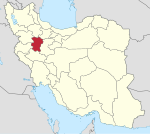
 Location of Hamadan Province in Iran | |
Coordinates: 34°47′54″N 48°30′53″E / 34.7982°N 48.5146°E / 34.7982; 48.5146Coordinates: 34°47′54″N 48°30′53″E / 34.7982°N 48.5146°E / 34.7982; 48.5146 | |
| Country | |
| Region | Region 4 |
| Capital | Hamadan |
| Counties | 8 |
| Area | |
| • Total | 19,368 km2 (7,478 sq mi) |
| Population (2011)[1] | |
| • Total | 1,758,268 |
| • Density | 91/km2 (240/sq mi) |
| Time zone | UTC+03:30 (IRST) |
| • Summer (DST) | UTC+04:30 (IRST) |
| Main language(s) | Persian Azerbaijani Lurish Kurdish |
| Website | www.instagram.com/iran_hamedan/ |
Hamadan Province (Persian: استان همدان), is one of the 31 provinces of Iran. Its center is Hamadan city. The province of Hamadan covers an area of 19,546 km². In the year 1996, Hamadan province had a population of approximately 1.7 million people; according to the National Census held in 2011 the population of the Province was 1,758,268 people.[1] In 2014 it was placed in Region 4.[2]
Other major cities of Hamadan province are: Hamadan, Toyserkan, Nahavand, Malayer, Asad Abad, Bahar, Famenin, Razan and Kabudrahang.
The counties of Hamadan Province are Kabudrahang County, Razan County, Famenin County, Bahar County, Hamadan County, Asadabad County, Tuyserkan County, Malayer County & Nahavand County.
Contents
1 Geography
2 Demographics and languages
2.1 Demographics
2.2 Languages
2.2.1 Counties Languages
3 History
4 Hamadan today
4.1 Administrative divisions
4.2 Colleges and universities
4.3 Attractions
5 References
6 External links
Geography

Hamadan province topography map
The province lies in an elevated region, with the 'Alvand' mountains, running from the north west to the south west. These are part of the Zagros mountain range of Iran.
Hamadan enjoys temperate warm summers and relatively cold winters.
Demographics and languages
Demographics
Malayer County has a population of 285,272 people, Nahavand County has a population of 178,683 people, Hamadan County has a population of 626,183 people, Kabudrahang County has a population of 137,919 people, Razan County has a population of 111,120 people, Famenin County has a population of 40,541 people, Bahar County has a population of 121,590 people, Asadabad County has a population of 104,566 people & Tuyserkan County has a population of 42,520 people.
Languages
Persian language: Spoken by the majority of Hamadan city and county centers, it's Iran's official language.[3][4]
Azerbaijani language: Most of the people living in the north and western side of Hamadan city speak Azeri as of their native language. (562 villages of province)[3][4]
Lurish: Most people living in the southern of province in Malayer, Nahavand and Samen (255 villages of province-Luri and Lak)[3][4]
Kurdish: Most people living in the west of province. (159 villages of province)[3][4]
Counties Languages
In Hamadan city, 80% of the people identified their language as Persian, 12% Azeri and 8% Luri, Kurdish and Laki.[5]
In the counties of Hamadan province, the Hamadan county (which mainly includes Hamadan city), 70% of the people are Persian, 22% Azeri and 8% Lurish, Kurdish and Laki.[3]
In Hamadan city, 97% of the people identified their language as Persian and 3% other languages.[6]
The population of Nahavand was 184160 (in 1997) with approximately 99% speaking Luri and Laki.[3]
The population of Malayer in 1997 was 297062 and approximately 45% speak Persian, 45% Luri and Laki and 10% Azeri.
The population of Tooserkan county was 118945 in 1997 and the majority of the population is Luri and Laki. Alongside a minority of Azeri of 22%.[3]
In Asadabad county, the population was 110077 (in 1997) and 63% were Persian, 19% Kurdish, 14% Azeri and 4% Luri and Laki.[3]
In Kabudarahang, the population in 1997 was 152318 with 90% speaking Azeri, 5% Persian and another 5% Kurdish.[3] In Razan county, the population was 123790 (in 1997) with 99.47% of the residents speaking Azeri and 0.53 speaking Kurdish.[3]
In Bahar country was 127600 with 86.3% speaking Azeri, 7.9% speaking Kurdish, 4.5% speaking Persian and 1.3% speaking Luri.[3]
History

The Achaemenid inscriptions of "Ganj-nameh".

Golden Rhyton, Achaemenid period, excavated in Hamadan.
Hamadan province is one of the most ancient parts of Iran and its civilization. Relics of this area confirm this fact. Today's Hamedan is what is left of Ecbatana, the Medes' capital before they formed a union with the Persians. The poet Ferdowsi says that Ecbatana was built by King Jamshid.
According to historical records, there was once a castle in this city by the name of Haft Hessar (Seven Walls) which had a thousand rooms and its grandeur equalled that of the Babylon Tower.
The structures of city are related to Diya Aku, a King of the Medes from 700 BC. According to Greek records, this territory was called 'Ekbatan' and 'Hegmataneh' by this King, thus transformed into a huge capital.
During the Parthian era, Ctesiphon became capital of Persia, and Hamedan became the summer capital and residence of the Parthian rulers. After the Parthians, the Sassanids constructed their summer palaces in Hamedan as well.
In the year 633 when the war of Nahavand took place and Hamadan came into the hands of the invading Arabs, at times it thrived and at times it declined and witnessed hardships. During the Buwayhids, it suffered plenty of damages. In the 11th century, the Seljuks shifted their capital from Baghdad to Hamadan once again.
The city of Hamadan was always at risk during the rise and fall of powers. It was completely destroyed during the Timurid invasion. But during the Safavid era the city thrived once more. In the 18th century, Hamadan surrendered to the Ottomans, but Hamadan was retaken by Nader Shah Afshari, and under the peace treaty between Iran and the Ottomans it was returned to Iran.
The city of Hamadan lay on the Silk Road and even in recent centuries enjoyed good prospects in commerce and trade being on the main road network in the western region of Iran.
According to local Jewish traditions, the City of Hamedan is mentioned in the Bible, as the capital of Ancient Persia in the days of King Ahasuerus in the Book of Esther. It was then known as Shushan. The Tombs of Mordecai and Esther are located in modern-day Hamadan.
Hamadan today
Administrative divisions
| Hamedan Province |
|---|
 Hamadan Famenin Razan Kabudarahang Bahar Asad Malayer Tuyserkan Nahavand |
The province has a population of over 1,820,000 million. (As of 2008)
The province is divided into 8 Shahrestans (≈counties), which in turn are divided into 23 Bakhshs (≈districts) in total. These divisions are shown on the map as well as the center of each county and the neighbor provinces.
Colleges and universities
- Bu-Ali Sina University
Hamedan Medical University[7]
- Hamedan University of Technology[8]
- Islamic Azad University of Hamedan[9]
- Islamic Azad University of Nahavand
- Islamic Azad University of Toyserkan[10]
- Malayer University[11]
- Payam Noor University of Bahar
- Payam Noor University of Hamedan
- Payam Noor University of Kabootar Ahang
- Payam Noor University of Nahavand
- Payam Noor University of Razan
- Payam Noor University of Toyserkan
Attractions
The Cultural Heritage of Iran lists 442 sites of historical and cultural significance located in Hamadan, thus making the province a rich one in terms of historical attractions.
Some of the most popular sites are:
- Tomb of Baba Taher the poet
- Ganj Nameh inscriptions of Darius The Great
- Tomb of Esther and Mordechai
- Ali Sadr (Ardeles) cave
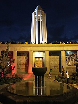
- Tomb of Avicenna
- Waterfall of Ganjnameh
- Stone Lion of Hamedan
- Abass Abad jangle(Baugh)
- Qorban Building
- Alavian Tomb
- Eram Park
- Hegmatane (Ekbatan) City of 5000 years ago
- Imam(pahlavi) Sq
- Alvand Mountain
- Grand Bazaar of Mozafarieh
References
^ ab Selected Findings of National Population and Housing Census 2011 Archived May 31, 2013, at the Wayback Machine.
^ "همشهری آنلاین-استانهای کشور به ۵ منطقه تقسیم شدند (Provinces were divided into 5 regions)". Hamshahri Online (in Persian). 22 June 2014. Archived from the original on 23 June 2014..mw-parser-output cite.citation{font-style:inherit}.mw-parser-output q{quotes:"""""""'""'"}.mw-parser-output code.cs1-code{color:inherit;background:inherit;border:inherit;padding:inherit}.mw-parser-output .cs1-lock-free a{background:url("//upload.wikimedia.org/wikipedia/commons/thumb/6/65/Lock-green.svg/9px-Lock-green.svg.png")no-repeat;background-position:right .1em center}.mw-parser-output .cs1-lock-limited a,.mw-parser-output .cs1-lock-registration a{background:url("//upload.wikimedia.org/wikipedia/commons/thumb/d/d6/Lock-gray-alt-2.svg/9px-Lock-gray-alt-2.svg.png")no-repeat;background-position:right .1em center}.mw-parser-output .cs1-lock-subscription a{background:url("//upload.wikimedia.org/wikipedia/commons/thumb/a/aa/Lock-red-alt-2.svg/9px-Lock-red-alt-2.svg.png")no-repeat;background-position:right .1em center}.mw-parser-output .cs1-subscription,.mw-parser-output .cs1-registration{color:#555}.mw-parser-output .cs1-subscription span,.mw-parser-output .cs1-registration span{border-bottom:1px dotted;cursor:help}.mw-parser-output .cs1-hidden-error{display:none;font-size:100%}.mw-parser-output .cs1-visible-error{font-size:100%}.mw-parser-output .cs1-subscription,.mw-parser-output .cs1-registration,.mw-parser-output .cs1-format{font-size:95%}.mw-parser-output .cs1-kern-left,.mw-parser-output .cs1-kern-wl-left{padding-left:0.2em}.mw-parser-output .cs1-kern-right,.mw-parser-output .cs1-kern-wl-right{padding-right:0.2em}
^ abcdefghijk "Hamedan provinces - Population and ethnicites". Retrieved August 30, 2016.
[dead link] accessed on March 12, 2006. Replaced with Archive link on February 22, 2010.
^ abcd جمعيت و قوميتها Archived 2006-04-06 at the Wayback Machine.
^ "Archived copy". Archived from the original on 2013-02-02. Retrieved 2013-05-13.CS1 maint: Archived copy as title (link)
^ Official statistics from 1997 (1375) - Hamadan provinces - Population and ethnicites -"Archived copy". Archived from the original on 2008-05-12. Retrieved 2010-02-22.CS1 maint: Archived copy as title (link) CS1 maint: BOT: original-url status unknown (link)
accessed on March 12, 2006. Replaced with Archive link on Feb 22, 2010.
^ http://www.umsha.ac.ir/
^ http://www.hut.ac.ir/
^ https://web.archive.org/web/20050308083048/http://www.iauh.ac.ir/
^ [1][permanent dead link]
^ http://www.malayeru.ac.ir/
External links
- Official website of Hamadan Governorship
- Hamadan Cultural Heritage Organization
- Official website of Hegmataneh (Ecbatana)
Hamedān entries in the Encyclopædia Iranica
