Middlesex County, Massachusetts
Middlesex County, Massachusetts | ||
|---|---|---|
| County of Massachusetts | ||
| County of Middlesex | ||
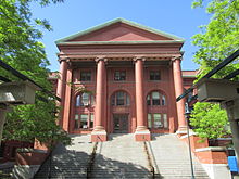 Middlesex South Registry of Deeds in Cambridge | ||
| ||
 Location in the U.S. state of Massachusetts | ||
 Massachusetts's location in the U.S. | ||
| Founded | May 10, 1643 | |
| Seat | Lowell and Cambridge | |
| Largest city | Lowell | |
| Area | ||
| • Total | 847 sq mi (2,194 km2) | |
| • Land | 818 sq mi (2,119 km2) | |
| • Water | 29 sq mi (75 km2), 3.5% | |
| Population | ||
| • (2010) | 1,503,085 | |
| • Density | 1,838/sq mi (710/km2) | |
| Congressional districts | 3rd, 4th, 5th, 6th, 7th | |
| Time zone | Eastern: UTC−5/−4 | |

Middlesex County is a county in the Commonwealth of Massachusetts, in the United States. As of 2016, the estimated population was 1,589,774,[1] making it the twenty-first most populous county in the United States, and the most populous county in both Massachusetts and New England. As part of the 2010 national census, the Commonwealth's mean center of population[2] for that year was geo-centered in Middlesex County, in the town of Natick at (42°16′20″N 71°21′48″W / 42.272291°N 71.363370°W / 42.272291; -71.363370).[3] (This is not to be confused with the geographic center of Massachusetts, which is in Rutland, in neighboring Worcester County.) Middlesex County is included in the Census Bureau’s Boston–Cambridge–Newton, MA–NH Metropolitan Statistical Area.
On July 11, 1997, the Massachusetts legislature voted to abolish the executive government of Middlesex County due primarily to the county's insolvency. Though Middlesex County continues to exist as a geographic boundary[4] it is used primarily as district jurisdictions within the court system and for other administrative purposes, such as an indicator for elections. The National Weather Service weather alerts (such as severe thunderstorm warning) continue issuances based upon Massachusetts' counties.
Contents
1 History
1.1 Law and government
1.2 Administrative structure today
2 Geography
2.1 Adjacent counties
2.2 National protected areas
3 Demographics
3.1 Demographic breakdown by town
3.1.1 Income
4 Politics
5 Communities
5.1 Cities
5.2 Towns
5.3 Census-designated places
5.4 Other villages and neighborhoods
6 Culture
7 See also
8 References
8.1 Bibliography
9 Further reading
10 External links
History
The county was created by the Massachusetts General Court on May 10, 1643, when it was ordered that "the whole plantation within this jurisdiction be divided into four shires." Middlesex initially contained Charlestown, Cambridge, Watertown, Sudbury, Concord, Woburn, Medford, Wayland, and Reading.[5] In 1649 the first Middlesex County Registry of Deeds was created in Cambridge.
On April 19, 1775, Middlesex was site of the first armed conflict of the American Revolutionary War.
In 1855, the Massachusetts State Legislature created a minor Registry of Deeds for the Northern District of Middlesex County in Lowell.[5]
In the late 19th century and early 20th century, Boston annexed several of its adjacent cities and towns including Charlestown and Brighton from Middlesex County, resulting in an enlargement and accretion toward Suffolk County.[5]
Beginning prior to dissolution of the executive county government, the county comprised two regions with separate county seats for administrative purposes:
- The Middlesex-North District (smaller) with its county seat in Lowell under the Registry of Deeds consisted of the city of Lowell, and its adjacent towns of Billerica, Carlisle, Chelmsford, Dracut, Dunstable, Tewksbury, Tyngsborough, Westford and Wilmington.
- The Middlesex-South District (larger) with the county seat in Cambridge[6] consisted of the remaining 44 cities and towns of Middlesex County.[7]
Since the start of the 21st century much of the current and former county offices have physically decentralized from the Cambridge seat, with the sole exceptions being the Registry of Deeds and the Middlesex Probate and Family Court, which both retain locations in Cambridge and Lowell. Since the first quarter of 2008, the Superior Courthouse[8][9] has been seated in the city of Woburn;[10][11] the Sheriff's Office is now administratively seated in the city of Medford and the Cambridge-based County Jail[12] has since been amalgamated with another county jail facility in Billerica.[13] The Cambridge District Court (which has jurisdiction for Arlington, Belmont and Cambridge); along with the Middlesex County District Attorney's Office, although not a part of the Middlesex County government, was also relatedly forced to relocate to Medford at the time of the closure of the Superior Courthouse building in Cambridge.[14][15]
Law and government
Of the fourteen counties of Massachusetts, Middlesex is one of eight[16] which have had no county government or county commissioners since July 1, 1998, when county functions were assumed by state agencies at local option following a change in state law.[4] Immediately prior to its dissolution, the executive branch consisted of three County Commissioners elected at-large to staggered four-year terms. There was a County Treasurer elected to a six-year term. The county derived its revenue primarily from document filing fees at the Registries of Deeds and from a Deeds Excise Tax; also a transfer tax was assessed on the sale price of real estate and collected by the Registries of Deeds.[17]
Budgets as proposed by the County Commissioners were approved by a County Advisory Board that consisted of a single representative of each of the 54 cities and towns in Middlesex County. The votes of the individual members of the Advisory Board were weighted based on the overall valuation of property in their respective communities.
The County Sheriff and two Registers of Deeds (one for the Northern District at Lowell and another for the Southern District at Cambridge) are each elected to serve six-year terms.[18] Besides the employees of the Sheriff's Office and the two Registries of Deeds, the county had a Maintenance Department, a Security Department, some administrative staff in the Treasurer's and Commissioners' Offices, and the employees of the hospital.
The country government also owned and operated the Superior Courthouse, one of which was formerly in Cambridge (since 2008 relocated to Woburn.)[8] and one in Lowell; and the defunct Middlesex County Hospital in the city of Waltham.
The legislation abolishing the Middlesex County executive retained the Sheriff and Registers of Deeds as independently elected officials, and transferred the Sheriff's Office under the state Department of Public Safety and the two Registry of Deeds offices to the Massachusetts Secretary of State's Office.[19] Additionally, all county maintenance and security employees were absorbed into the corresponding staffs of the Massachusetts Trial Court. The legislation also transferred ownership of the two Superior Courthouses to the Commonwealth of Massachusetts. The hospital was closed. Finally, the office of County Commissioner was immediately abolished and the office of County Treasurer was abolished as of December 31, 2002.[20] Any county roads transferred to the Commonwealth as part of the dissolution. The other administrative duties (such as Sheriff, Department of Deeds and court system, etc.) and all supporting staff were transferred under the Commonwealth as well.
Administrative structure today
Records of land ownership in Middlesex County continue to be maintained at the two Registries of Deeds. Besides the Sheriff and the two Registers of Deeds, the Middlesex District Attorney, the Middlesex Register of Probate and the Middlesex Clerk of Courts (which were already part of state government before the abolition of Middlesex County government) are all elected countywide to six-year terms.
In Middlesex County (as in the entirety of the Commonwealth of Massachusetts), the governmental functions such as property tax assessment and collection, public education, road repair and maintenance, and elections were all conducted at the municipal city and town level and not by the county government.
In 2012 the 22-story Superior Court Building in Cambridge which was transferred from the abolished Executive County government was sold[21][22] by the Commonwealth of Massachusetts.[23] Due to its transfer from state control,[24] many local residents had tried to force the private developers to reduce the overall height of the structure.[25][26]
Even following abolition of the executive branch for county government in Middlesex, communities are still granted a right by the Massachusetts state legislature to form their own regional compacts for sharing of services and costs thereof.
Clerk of Courts: | Michael A. Sullivan |
|---|---|
District Attorney: | Marian T. Ryan |
Register of Deeds: | Richard P. Howe, Jr. (North at Lowell) Maria C. Curtatone (South at Cambridge) |
Register of Probate: | Tara E. DeCristofaro |
County Sheriff: | Peter J. Koutoujian [1] |
| State government | |
State Representative(s): | 37 Representatives: [2] |
State Senator(s): | 16 Senators: [3] |
Governor's Councilor(s): | |
| Federal government | |
U.S. Representative(s): | James P. McGovern (D-2nd District) Joseph P. Kennedy III (D-4th District) Niki Tsongas (D-3rd District) Seth Moulton (D-6th District) Katherine Clark (D-5th District) Michael Capuano (D-7th District) |
U.S. Senators: | Elizabeth Warren (D), Ed Markey (D) |
Geography
According to the U.S. Census Bureau, the county has a total area of 847 square miles (2,190 km2), of which 818 square miles (2,120 km2) is land and 29 square miles (75 km2) (3.5%) is water.[27] It is the third-largest county in Massachusetts by land area.
It is bounded southeast by the Charles River, and drained by the Merrimack, Nashua, and Concord rivers, and other streams.[28]
The MetroWest region comprises much of the southern portion of the county.
Adjacent counties
Hillsborough County, New Hampshire (north)
Essex County (northeast)
Suffolk County (southeast)
Norfolk County (south)
Worcester County (west)
National protected areas
- Assabet River National Wildlife Refuge
- Great Meadows National Wildlife Refuge
- Longfellow House–Washington's Headquarters National Historic Site
- Lowell National Historical Park
- Minute Man National Historical Park
Oxbow National Wildlife Refuge (part)
Demographics
| Historical population | |||
|---|---|---|---|
| Census | Pop. | %± | |
| 1790 | 42,769 | — | |
| 1800 | 46,928 | 9.7% | |
| 1810 | 52,789 | 12.5% | |
| 1820 | 61,472 | 16.4% | |
| 1830 | 77,961 | 26.8% | |
| 1840 | 106,611 | 36.7% | |
| 1850 | 161,383 | 51.4% | |
| 1860 | 216,354 | 34.1% | |
| 1870 | 274,353 | 26.8% | |
| 1880 | 317,830 | 15.8% | |
| 1890 | 431,167 | 35.7% | |
| 1900 | 565,696 | 31.2% | |
| 1910 | 669,915 | 18.4% | |
| 1920 | 778,352 | 16.2% | |
| 1930 | 934,924 | 20.1% | |
| 1940 | 971,390 | 3.9% | |
| 1950 | 1,064,569 | 9.6% | |
| 1960 | 1,238,742 | 16.4% | |
| 1970 | 1,397,268 | 12.8% | |
| 1980 | 1,367,034 | −2.2% | |
| 1990 | 1,398,468 | 2.3% | |
| 2000 | 1,465,396 | 4.8% | |
| 2010 | 1,503,085 | 2.6% | |
| Est. 2016 | 1,589,774 | [29] | 5.8% |
| U.S. Decennial Census[30] 1790-1960[31] 1900-1990[32] 1990-2000[33] 2010-2013[1] | |||
As of 2006[update], Middlesex County was tenth in the United States on the list of most millionaires per county.[34]
As of the 2010 United States Census, there were 1,503,085 people, 580,688 households, and 366,656 families residing in the county.[35] The population density was 1,837.9 inhabitants per square mile (709.6/km2). There were 612,004 housing units at an average density of 748.3 per square mile (288.9/km2).[36] The racial makeup of the county was 80.0% white, 9.3% Asian, 4.7% black or African American, 0.2% American Indian, 3.3% from other races, and 2.5% from two or more races. Those of Hispanic or Latino origin made up 6.5% of the population.[35]
The largest ancestry groups were:[37]
- 23.5% Irish
- 16.2% Italian
- 11.2% English
- 7.1% German
- 5.6% French
- 4.0% Polish
- 3.6% French Canadian
- 3.2% Chinese
- 3.1% Portuguese
- 2.9% American
- 2.7% Scottish
- 2.6% Russian
- 2.5% Indian
- 2.4% Brazilian
- 2.0% Scotch-Irish
- 2.0% Puerto Rican
- 1.7% Swedish
- 1.6% Greek
- 1.2% Sub-Saharan African
- 1.2% Haitian
- 1.2% Armenian
- 1.1% Canadian
- 1.0% Cambodian
- 1.0% Arab
Of the 580,688 households, 31.0% had children under the age of 18 living with them, 49.5% were married couples living together, 10.1% had a female householder with no husband present, 36.9% were non-families, and 27.8% of all households were made up of individuals. The average household size was 2.49 and the average family size was 3.10. The median age was 38.5 years.[35]
The median income for a household in the county was $77,377 and the median income for a family was $97,382. Males had a median income of $64,722 versus $50,538 for females. The per capita income for the county was $40,139. About 5.1% of families and 7.6% of the population were below the poverty line, including 8.0% of those under age 18 and 8.0% of those age 65 or over.[38]
79.6% spoke English, 4.3% Spanish, 2.7% Portuguese, 1.6% Italian, 1.6% Chinese including Mandarin and other Chinese dialects and 1.5% French as their first language. Middlesex County has the largest Irish-American population of any U.S. county with a plurality of Irish ancestry.[39][40]
Demographic breakdown by town
Income
The ranking of unincorporated communities that are included on the list are reflective if the census designated locations and villages were included as cities or towns. Data is from the 2007-2011 American Community Survey 5-Year Estimates.[41][42][43]
| Rank | Town | Per capita income | Median household income | Median family income | Population | Number of households | |
|---|---|---|---|---|---|---|---|
| 1 | Weston | Town | $96,475 | $180,815 | $220,441 | 11,229 | 3,557 |
| 2 | Sherborn | Town | $70,983 | $152,083 | $183,456 | 4,102 | 1,463 |
| 3 | Wayland | Town | $70,185 | $125,076 | $151,812 | 12,939 | 4,902 |
| 4 | Carlisle | Town | $68,060 | $159,063 | $171,167 | 4,814 | 1,612 |
| 5 | Lexington | Town | $67,584 | $136,610 | $158,888 | 31,129 | 11,411 |
| 6 | Concord | Town | $67,374 | $127,951 | $156,352 | 17,523 | 6,197 |
| 7 | Winchester | Town | $65,172 | $127,665 | $160,706 | 21,205 | 7,611 |
| 8 | Sudbury | Town | $63,862 | $159,713 | $173,587 | 17,482 | 5,613 |
| 9 | Newton | City | $60,323 | $109,724 | $141,944 | 84,583 | 30,735 |
| 10 | Lincoln | Town | $57,471 | $130,523 | $141,667 | 6,480 | 2,150 |
| 11 | Hopkinton | Town | $56,939 | $126,350 | $149,213 | 14,691 | 4,893 |
Chestnut Hill (02467) | ZCTA | $55,947 | $114,140 | $151,375 | 21,952 | 6,237 | |
| 12 | Belmont | Town | $54,361 | $99,529 | $121,250 | 24,548 | 9,465 |
Cochituate | CDP | $52,936 | $107,589 | $133,082 | 6,384 | 2,496 | |
| 13 | Boxborough | Town | $51,159 | $103,918 | $134,583 | 4,957 | 1,984 |
| 14 | Acton | Town | $49,603 | $109,491 | $135,000 | 21,656 | 7,924 |
| 15 | Natick | Town | $49,012 | $90,046 | $117,259 | 32,729 | 13,440 |
| 16 | Bedford | Town | $48,899 | $101,886 | $128,448 | 13,192 | 4,951 |
| 17 | Stow | Town | $48,448 | $112,130 | $132,061 | 6,488 | 2,328 |
West Concord | CDP | $47,633 | $103,693 | $145,242 | 6,134 | 2,069 | |
| 18 | Holliston | Town | $47,624 | $107,374 | $125,236 | 13,512 | 4,918 |
| 19 | Westford | Town | $47,587 | $119,511 | $135,000 | 21,716 | 7,308 |
| 20 | Arlington | Town | $47,571 | $85,059 | $107,862 | 42,570 | 19,007 |
| 21 | Groton | Town | $47,003 | $117,903 | $135,143 | 10,478 | 3,650 |
| 22 | Ashland | Town | $46,626 | $93,770 | $116,799 | 16,305 | 6,484 |
| 23 | Cambridge | City | $46,242 | $69,017 | $94,536 | 104,322 | 45,386 |
| 24 | Reading | Town | $44,949 | $99,131 | $117,477 | 24,504 | 9,055 |
| 25 | Chelmsford | Town | $42,535 | $90,895 | $110,967 | 33,610 | 13,304 |
| 26 | North Reading | Town | $42,256 | $104,069 | $116,729 | 14,703 | 5,077 |
| 27 | Dunstable | Town | $41,937 | $109,205 | $121,406 | 3,128 | 1,087 |
| 28 | Littleton | Town | $41,815 | $103,438 | $114,094 | 8,810 | 3,198 |
Middlesex County | County | $41,453 | $79,691 | $100,267 | 1,491,762 | 577,349 | |
| 29 | Watertown | Town | $41,090 | $76,718 | $90,521 | 31,792 | 14,042 |
| 30 | Wakefield | Town | $40,227 | $85,379 | $112,293 | 24,794 | 10,058 |
| 31 | Burlington | Town | $40,083 | $92,236 | $107,339 | 24,207 | 9,177 |
| 32 | Melrose | City | $39,873 | $84,599 | $105,893 | 26,864 | 10,963 |
Groton | CDP | $39,208 | $55,446 | $127,708 | 1,077 | 507 | |
Hopkinton | CDP | $38,507 | $71,536 | $105,882 | 2,110 | 877 | |
| 33 | Tyngsborough | Town | $38,067 | $101,103 | $111,780 | 11,198 | 3,797 |
| 34 | Stoneham | Town | $37,573 | $77,476 | $95,490 | 21,413 | 8,909 |
| 35 | Marlborough | City | $37,314 | $72,853 | $94,770 | 38,087 | 15,856 |
| 36 | Wilmington | Town | $37,084 | $100,861 | $107,436 | 22,116 | 7,200 |
| 37 | Pepperell | Town | $37,081 | $84,618 | $102,946 | 11,407 | 4,125 |
| 38 | Maynard | Town | $36,818 | $77,255 | $93,116 | 10,083 | 4,222 |
| 39 | Tewksbury | Town | $36,509 | $86,378 | $103,008 | 28,778 | 10,670 |
| 40 | Hudson | Town | $36,141 | $76,714 | $95,746 | 18,845 | 7,679 |
Pepperell | CDP | $35,227 | $68,500 | $65,417 | 2,239 | 852 | |
Massachusetts | State | $35,051 | $65,981 | $83,371 | 6,512,227 | 2,522,409 | |
| 41 | Medford | City | $34,615 | $72,033 | $83,078 | 55,843 | 22,461 |
Hudson | CDP | $33,734 | $68,812 | $86,216 | 14,797 | 6,129 | |
| 42 | Woburn | City | $33,725 | $72,540 | $87,924 | 37,831 | 15,357 |
| 43 | Waltham | City | $33,717 | $68,326 | $82,233 | 60,209 | 23,520 |
| 44 | Framingham | City | $33,665 | $66,047 | $86,977 | 67,844 | 26,167 |
Pinehurst | CDP | $33,572 | $95,038 | $100,650 | 7,289 | 2,414 | |
| 45 | Billerica | Town | $33,347 | $88,531 | $98,371 | 39,930 | 13,859 |
| 46 | Somerville | City | $32,785 | $64,480 | $71,518 | 75,566 | 31,476 |
| 47 | Ashby | Town | $32,434 | $82,614 | $84,655 | 3,030 | 1,060 |
| 48 | Ayer | Town | $32,179 | $54,899 | $78,947 | 7,370 | 3,063 |
Littleton Common | CDP | $32,058 | $80,352 | $105,217 | 2,907 | 1,131 | |
| 49 | Dracut | Town | $31,533 | $71,824 | $88,281 | 29,249 | 11,173 |
| 50 | Townsend | Town | $31,201 | $76,250 | $91,023 | 8,906 | 3,114 |
East Pepperell | CDP | $30,475 | $74,077 | $79,104 | 2,195 | 811 | |
Ayer | CDP | $30,456 | $42,055 | $79,708 | 2,573 | 1,205 | |
United States | Country | $27,915 | $52,762 | $64,293 | 306,603,772 | 114,761,359 | |
Townsend | CDP | $27,166 | $51,512 | $71,023 | 968 | 453 | |
| 51 | Malden | City | $26,893 | $52,842 | $65,763 | 58,821 | 23,422 |
Shirley | CDP | $24,943 | $41,250 | $41,838 | 1,330 | 593 | |
| 52 | Everett | City | $24,575 | $48,319 | $58,045 | 41,079 | 15,681 |
| 53 | Shirley | Town | $24,427 | $71,146 | $78,493 | 7,235 | 2,189 |
| 54 | Lowell | City | $23,600 | $51,471 | $57,934 | 105,860 | 39,399 |
Devens | CDP | $13,933 | $72,986 | $73,194 | 1,704 | 113 |
Politics
| Voter registration and party enrollment as of February 1, 2017[44] | |||||
|---|---|---|---|---|---|
| Party | Number of voters | Percentage | |||
Democratic | 358,794 | 35.20% | |||
Republican | 97,072 | 9.52% | |||
| Unenrolled | 552,530 | 54.21% | |||
| Minor Parties | 1,857 | 0.18% | |||
| Total | 1,019,169 | 100% | |||
| Year | Republican | Democratic | Third parties |
|---|---|---|---|
2016 | 27.6% 219,793 | 65.3% 520,360 | 7.1% 56,582 |
2012 | 35.5% 267,321 | 62.6% 471,804 | 2.0% 15,045 |
2008 | 33.9% 245,766 | 64.0% 464,484 | 2.2% 15,781 |
2004 | 34.5% 237,815 | 64.0% 440,862 | 1.5% 10,283 |
2000 | 30.3% 198,914 | 61.5% 404,043 | 8.2% 54,091 |
1996 | 27.1% 169,926 | 63.4% 398,190 | 9.5% 59,861 |
1992 | 28.1% 193,703 | 49.9% 343,994 | 22.0% 151,756 |
1988 | 43.8% 290,352 | 54.6% 361,563 | 1.6% 10,713 |
1984 | 49.4% 319,604 | 50.3% 325,065 | 0.3% 2,085 |
1980 | 40.3% 256,999 | 42.5% 270,751 | 17.2% 109,929 |
1976 | 40.4% 260,044 | 55.9% 359,919 | 3.6% 23,419 |
1972 | 43.6% 269,064 | 55.9% 345,343 | 0.5% 3,244 |
1968 | 32.6% 188,304 | 64.1% 370,310 | 3.3% 18,982 |
1964 | 23.4% 134,729 | 76.3% 439,790 | 0.4% 2,291 |
1960 | 40.8% 246,126 | 59.0% 356,130 | 0.2% 1,260 |
1956 | 61.1% 343,125 | 38.6% 216,668 | 0.3% 1,580 |
1952 | 57.0% 316,069 | 42.7% 236,910 | 0.3% 1,626 |
1948 | 47.0% 228,262 | 51.1% 248,240 | 1.9% 9,406 |
1944 | 52.8% 236,102 | 47.0% 210,253 | 0.2% 725 |
1940 | 52.4% 242,658 | 47.2% 218,663 | 0.5% 2,116 |
1936 | 47.6% 199,704 | 45.2% 189,512 | 7.2% 30,304 |
1932 | 50.4% 184,486 | 47.6% 174,257 | 1.9% 7,008 |
1928 | 52.0% 189,189 | 47.6% 173,339 | 0.4% 1,313 |
1924 | 63.7% 162,530 | 25.3% 64,544 | 11.0% 28,161 |
1920 | 69.9% 156,636 | 27.5% 61,661 | 2.6% 5,781 |
1916 | 53.8% 60,802 | 44.1% 49,844 | 2.2% 2,426 |
1912 | 29.7% 30,511 | 35.7% 36,689 | 34.7% 35,667 |
1908 | 61.2% 58,672 | 32.7% 31,362 | 6.1% 5,853 |
1904 | 60.6% 55,704 | 35.8% 32,889 | 3.6% 3,275 |
1900 | 60.6% 49,638 | 36.0% 29,476 | 3.5% 2,841 |
1896 | 71.4% 57,281 | 24.4% 19,591 | 4.2% 3,394 |
1892 | 52.4% 40,375 | 45.1% 34,769 | 2.5% 1,946 |
1888 | 54.3% 35,768 | 43.4% 28,570 | 2.3% 1,519 |
1884 | 48.5% 27,654 | 39.0% 22,206 | 12.6% 7,157 |
1880 | 59.3% 30,339 | 38.7% 19,801 | 2.0% 1,013 |
1876 | 58.0% 27,304 | 41.6% 19,561 | 0.4% 193 |
Communities
Most municipalities in Middlesex County have a town form of government; the remainder are cities, and are so designated on this list. Villages listed below are census or postal divisions, but have no separate corporate or statutory existence from the cities and towns in which they are located.
Cities
Cambridge (traditional county seat) de jure
- Everett
- Framingham
Lowell (traditional county seat)- Malden
- Marlborough
- Medford
- Melrose
- Newton
- Somerville
- Waltham
- Watertown
- Woburn
Towns
- Acton
- Arlington
- Ashby
- Ashland
- Ayer
- Bedford
- Belmont
- Billerica
- Boxborough
- Burlington
- Carlisle
- Chelmsford
- Concord
- Dracut
- Dunstable
- Groton
- Holliston
- Hopkinton
- Hudson
- Lexington
- Lincoln
- Littleton
- Maynard
- Natick
- North Reading
- Pepperell
- Reading
- Sherborn
- Shirley
- Stoneham
- Stow
- Sudbury
- Tewksbury
- Townsend
- Tyngsborough
- Wakefield
- Wayland
- Westford
- Weston
- Wilmington
- Winchester
Census-designated places
- Ayer
- Cochituate
- Devens
- East Pepperell
- Groton
- Hopkinton
- Hudson
- Littleton Common
- Pepperell
- Pinehurst
- Shirley
- Townsend
- West Concord
Other villages and neighborhoods
- Auburndale
- Chestnut Hill
- East Lexington
- Felchville
- Forge Village
- Gleasondale
- Graniteville
- Melrose Highlands
- Nabnasset
- Newton Centre
- Newton Highlands
- Newton Lower Falls
- Newton Upper Falls
- Newtonville
- Nonantum
- North Billerica
- North Chelmsford
- Pingryville
- Saxonville
- Thompsonville
- Waban
- West Newton
Culture
Middlesex County is home to the Middlesex County Volunteers, a fife and drum corps that plays music from the 17th, 18th, 19th and 20th centuries. Founded in 1982 at the end of the United States Bicentennial celebration, the group performs extensively throughout New England. They have also performed at the Boston Pops, throughout the British Isles and Western Europe, and at the Edinburgh Military Tattoo's Salute to Australia in Sydney, Australia.
See also
Middlesex, historic county of England- Registry of Deeds (Massachusetts)
- National Register of Historic Places listings in Middlesex County, Massachusetts
- Middlesex Fells
- Middlesex Community College (Massachusetts)
- Middlesex Turnpike (Massachusetts)
- Middlesex County Sheriff's Office
References
^ ab "State & County QuickFacts". United States Census Bureau. Archived from the original on July 14, 2011. Retrieved August 26, 2013..mw-parser-output cite.citation{font-style:inherit}.mw-parser-output q{quotes:"""""""'""'"}.mw-parser-output code.cs1-code{color:inherit;background:inherit;border:inherit;padding:inherit}.mw-parser-output .cs1-lock-free a{background:url("//upload.wikimedia.org/wikipedia/commons/thumb/6/65/Lock-green.svg/9px-Lock-green.svg.png")no-repeat;background-position:right .1em center}.mw-parser-output .cs1-lock-limited a,.mw-parser-output .cs1-lock-registration a{background:url("//upload.wikimedia.org/wikipedia/commons/thumb/d/d6/Lock-gray-alt-2.svg/9px-Lock-gray-alt-2.svg.png")no-repeat;background-position:right .1em center}.mw-parser-output .cs1-lock-subscription a{background:url("//upload.wikimedia.org/wikipedia/commons/thumb/a/aa/Lock-red-alt-2.svg/9px-Lock-red-alt-2.svg.png")no-repeat;background-position:right .1em center}.mw-parser-output .cs1-subscription,.mw-parser-output .cs1-registration{color:#555}.mw-parser-output .cs1-subscription span,.mw-parser-output .cs1-registration span{border-bottom:1px dotted;cursor:help}.mw-parser-output .cs1-hidden-error{display:none;font-size:100%}.mw-parser-output .cs1-visible-error{font-size:100%}.mw-parser-output .cs1-subscription,.mw-parser-output .cs1-registration,.mw-parser-output .cs1-format{font-size:95%}.mw-parser-output .cs1-kern-left,.mw-parser-output .cs1-kern-wl-left{padding-left:0.2em}.mw-parser-output .cs1-kern-right,.mw-parser-output .cs1-kern-wl-right{padding-right:0.2em}
^ "Center of Population". United States Census Bureau. 2010. Retrieved January 28, 2018.Definition: The center is determined as the place where an imaginary, flat, weightless and rigid map of the United States would balance perfectly if all residents were of identical weight. In 2000, Edgar Springs, Mo., was announced as the new U.S. population center.
^ "Centers of Population by State: 2010". United States Census Bureau. 2010. Archived from the original on April 2, 2013. Retrieved September 16, 2014.
^ ab Mass. Gen. L. c. 34B
^ abc Davis, William T. Bench and Bar of the Commonwealth of Massachusetts, p. 44. The Boston History Company, 1895.
^ "Find a County". National Association of Counties. Archived from the original on 2011-05-31. Retrieved 2011-06-07.
^ Mass. Gen. L. c. 36, § 1
^ ab Moskowitz, Eric (February 14, 2008). "Court move a hassle for commuters". Retrieved January 29, 2018.
^ Redmond, Lisa (March 10, 2008). "Middlesex Superior Court moving to Woburn". Digital First Media. Lowell Sun. Retrieved January 31, 2018.WOBURN -- Middlesex Superior Court, currently located in the Edward J. Sullivan Courthouse in Cambridge, will move to a new facility in Woburn in the TradeCenter on Sylvan Road beginning Friday, according to Chief Justice for Administration and Management Robert A. Mulligan.
^ "Press Release: Middlesex Superior Court Moves to Woburn". Cummings Properties, LLC. March 17, 2008. Retrieved January 31, 2018.Woburn, MA, March 17, 2008 -- The new furniture has been installed, years of case files have been dusted off, moved and organized, and the computers are all hooked up and ready to go. After 40 years in Cambridge, the Superior Court is open and ready for business in Woburn. [ . . . ] Serving nearly all of the 54 communities in Middlesex County, the new Woburn building houses 15 courtrooms, clerks' offices, judges' chambers, the probation department, the law library, and more. In addition, the Court estimates that more than 400 people will use the building every day, including, lawyers, judges, administrative staff, jurors, plaintiffs, defendants, visitors, and others who work at the building and use the system.
^ Properties, Cummings (September 20, 2013). "Press Release:Middlesex Superior Court renews lease in Woburn". Cummings Properties, Business. Patch Media. Retrieved January 31, 2018.The Commonwealth of Massachusetts has extended its lease for the Middlesex County Superior Courthouse at TradeCenter 128 in Woburn for a seven-year term. This renewal comes five years after the Court moved from the Edward J. Sullivan Courthouse in Cambridge, which was in need of extensive renovations and has since been slated for redevelopment.
^ Hanson, Melissa (June 28, 2014). "Middlesex Jail in Cambridge closes". The Boston Globe. Archived from the original on 2018-01-29. Retrieved February 10, 2018. (Subscription required (help)).The Middlesex Jail at the Edward J. Sullivan Courthouse in Cambridge closed Saturday after 32 years of operation, according to Middlesex Sheriff Peter J. Koutoujian.
^ Boeri, David (June 30, 2014). "One Last Elevator Ride Down: Cambridge High-Rise Jail Is No More". WBUR. Retrieved February 10, 2018.A high-security weekend operation has emptied the Middlesex County Jail in Cambridge of all its inmates.
^ Barry, Rob (February 26, 2009). "Cambridge Court opens in Medford". WickedLocal. GateHouse Media, LLC. Retrieved February 10, 2018. (Subscription required (help)).The Cambridge District Court moved into Medford this week, placing itself in the former Cross Country building at 4040 Mystic Valley Pkwy.
^ Kenney, Joan; Whiting, Charlotte (February 17, 2009). "THIRD DISTRICT COURT OF MIDDLESEX COUNTY RELOCATES FROM CAMBRIDGE TO MEDFORD" (PDF). Public Information Office. Massachusetts Supreme Judicial Court. Boston Bar Association. Retrieved February 10, 2018.Chief Justice for Administration and Management Robert A. Mulligan today announced that the Third District Court of Middlesex County, currently located in the Edward J. Sullivan Courthouse in Cambridge, will move to a new court facility on the Mystic Valley Parkway in Medford after the close of business on February 20, 2009, and open for business at this new site on Monday, February 23, 2009.
^ "General Laws of Massachusetts, Chapter 34B. Abolition of County Government". Massachusetts General Court. Retrieved November 26, 2016.
^ Middlesex County Directory: 1993-1995, (Cambridge: Middlesex County Commissioners Office, 1995)
^ Mass. Gen. L. c. 34, § 4
^ Mass. Gen. L. c. 34B, § 10
^ Mass. Gen. L. c. 34B, § 2
^ Baldassari, Erin (December 17, 2012). "Leggat McCall wins bid for Sullivan Courthouse redevelopment in Cambridge". WickedLocal. GateHouse Media, LLC. Retrieved December 17, 2012. (Subscription required (help)).Leggat McCall Properties was selected from a pool of seven bidders to redevelop the 22-story, 600,000-square-foot EJ Sullivan Courthouse in East Cambridge, the state announced Friday, Dec. 14.
^ Parker, Brock (November 16, 2011). "State advertising 22-story Sullivan Courthouse, seeking to sell by September". Boston Globe Media Partners, LLC. Retrieved February 10, 2018. (Subscription required (help)).State officials are advertising for a buyer for the 22-story, asbestos-plagued Edward J. Sullivan Courthouse in Cambridge and hope to move prisoners housed in a county jail at the facility to another location by the spring of 2013.
^ Ansari, Esq., Maryam K. (December 19, 2012). "Cambridge Residents Contesting Plans for Sullivan Courthouse". FindLaw Network. Boston Real Estate Law News. Thomson Reuters. Retrieved February 10, 2018.
^ Goodison, Donna (July 20, 2017). "Cambridge courthouse judged fit for redo". Boston Herald and Herald Media. Retrieved February 10, 2018.The Appeals Court upheld a 2015 Land Court decision that determined the former Edward J. Sullivan Courthouse, when transferred from state ownership to private ownership under Boston developer Leggat McCall Properties, would still be considered a legal, preexisting nonconforming structure despite losing its government immunity from zoning rules.
^ Chesto, Jon (August 8, 2017). "A towering dilemma in East Cambridge". The Boston Globe. Archived from the original on 2017-08-11. Retrieved February 10, 2018. (Subscription required (help)).The developers who want to remodel the imposing former courthouse tower in East Cambridge and enliven its ground floor had hoped an appeals court decision last month was the final green light they needed.
^ Staff writer (July 20, 2017). "40 Thorndike Street". www.bldup.com. BLDUP. Retrieved February 10, 2018.Upcoming mixed-use development located steps from Kendall Square that will transform the existing 22-story Sullivan Courthouse and Middlesex Jail tower in East Cambridge into a 20-story mixed-use tower. The new 40 Thorndike Street will feature approximately 430,000 square feet of office, research & development space and 15,000 square feet of ground-floor retail, along with 24 apartment residences on lower floors. Lower office floors will be marketed to startup companies as innovation space. Retail will include a grocery store and a health club; a daycare could be included as well.
^ "2010 Census Gazetteer Files". United States Census Bureau. August 22, 2012. Archived from the original on September 14, 2014. Retrieved September 16, 2014.
^ Ripley, George; Dana, Charles A., eds. (1879). "Middlesex: I. A N. E. county of Massachusetts". The American Cyclopædia.
^ "Population and Housing Unit Estimates". Retrieved June 9, 2017.
^ "U.S. Decennial Census". United States Census Bureau. Archived from the original on May 12, 2015. Retrieved September 16, 2014.
^ "Historical Census Browser". University of Virginia Library. Retrieved September 16, 2014.
^ "Population of Counties by Decennial Census: 1900 to 1990". United States Census Bureau. Retrieved September 16, 2014.
^ "Census 2000 PHC-T-4. Ranking Tables for Counties: 1990 and 2000" (PDF). United States Census Bureau. Retrieved September 16, 2014.
^ Sahadi, Jeanne (March 28, 2006). "Top 10 millionaire counties". CNN.
^ abc "DP-1 Profile of General Population and Housing Characteristics: 2010 Demographic Profile Data". United States Census Bureau. Retrieved 2016-01-12.
^ "Population, Housing Units, Area, and Density: 2010 - County". United States Census Bureau. Retrieved 2016-01-12.
^ "DP02 SELECTED SOCIAL CHARACTERISTICS IN THE UNITED STATES – 2006-2010 American Community Survey 5-Year Estimates". United States Census Bureau. Retrieved 2016-01-12.
^ "DP03 SELECTED ECONOMIC CHARACTERISTICS – 2006-2010 American Community Survey 5-Year Estimates". United States Census Bureau. Retrieved 2016-01-12.
^ "US Census Press Releases". archive.org. 25 February 2006. Archived from the original on 2006-02-25.
^ "Archived copy". Archived from the original on 2015-10-12. Retrieved 2017-12-07.CS1 maint: Archived copy as title (link)
^ "SELECTED ECONOMIC CHARACTERISTICS 2007-2011 American Community Survey 5-Year Estimates". U.S. Census Bureau. Retrieved 2013-01-26.
^ "ACS DEMOGRAPHIC AND HOUSING ESTIMATES 2007-2011 American Community Survey 5-Year Estimates". U.S. Census Bureau. Retrieved 2013-01-26.
^ "HOUSEHOLDS AND FAMILIES 2007-2011 American Community Survey 5-Year Estimates". U.S. Census Bureau. Retrieved 2013-01-26.
^ "Registration and Party Enrollment Statistics as of October 13, 2010" (PDF). Massachusetts Elections Division. Retrieved 2010-03-14.
^ Leip, David. "Dave Leip's Atlas of U.S. Presidential Elections". uselectionatlas.org.
Bibliography
History of Middlesex County, Massachusetts, Volume 1 (A-H), Volume 2 (L-W) by Samuel Adams Drake, published 1879 and 1880. 572 and 505 pages.
Ancient Middlesex with Brief Biographical Sketches. By Levi Swanton Gould, published 1905, 366 pages.
Further reading
Jedidiah Morse (1797). "Middlesex". The American Gazetteer. Boston, Massachusetts: At the presses of S. Hall, and Thomas & Andrews.
- Edwin P. Conklin, Middlesex County and Its People: A History. In Four Volumes. New York: Lewis Historical Pub. Co., 1927.
- Samuel Adams Drake, History of Middlesex County, Massachusetts: Containing Carefully Prepared Histories of Every City and Town in the County. Boston: Estes and Lauriat, 1880. Volume 1 | Volume 2
- D. Hamilton Hurd, History of Middlesex County, Massachusetts: With Biographical Sketches of Many of its Pioneers and Prominent Men. In Three Volumes. Philadelphia, PA: J.W. Lewis & Co., 1890. Volume 1 | Volume 2 | Volume 3
- Robert H. Rodgers, Middlesex County in the Colony of the Massachusetts Bay in New England: Records of Probate and Administration, February 1670/71-June 1676. Rockport, ME: Picton Press, 2005.
External links
| Wikimedia Commons has media related to Middlesex County, Massachusetts. |
- Middlesex County Sheriff's Department
1856 Map of Middlesex County by Henry F. Walling- Walling & Gray. 1871 Map of Middlesex County Plate 44-45 from the 1871 Atlas of Massachusetts.
- National Register of Historic Places listing for Middlesex Co., Massachusetts
- Middlesex County entry from Hayward's New England Gazetteer of 1839
- Map of cities and towns of Massachusetts
- Massachusetts County Map
History of Middlesex County by Samual Adams Drake, 1880. Contains histories of each town in the county.
History of Middlesex County, Massachusetts With Biographical Sketches of Many of Its Pioneers and Prominent Men, edited by Duane Hamilton Hurd. J. W. Lewis & Co., Philadelphia. 1890.- Middlesex North District Registry of Deeds
- Middlesex South District Registry of Deeds
- League of Women Voters, Massachusetts: County Government
Places adjacent to Middlesex County, Massachusetts | ||||||||||
|---|---|---|---|---|---|---|---|---|---|---|
| ||||||||||
Municipalities and communities of Middlesex County, Massachusetts, United States | ||
|---|---|---|
County seats: Cambridge and Lowell | ||
| Cities |
|  |
| Towns |
| |
| CDPs |
| |
| Other villages |
| |
Boston (capital) | |
| Topics |
|
| Society |
|
| Regions |
|
| Counties |
|
| Cities |
|
Coordinates: 42°29′N 71°23′W / 42.49°N 71.39°W / 42.49; -71.39


