Włoszczowa County
Włoszczowa County Powiat włoszczowski | |||
|---|---|---|---|
County | |||
| |||
 Location within the voivodeship | |||
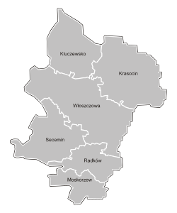 Division into gminas | |||
Coordinates (Włoszczowa): 50°51′15″N 19°58′1″E / 50.85417°N 19.96694°E / 50.85417; 19.96694Coordinates: 50°51′15″N 19°58′1″E / 50.85417°N 19.96694°E / 50.85417; 19.96694 | |||
| Country | |||
| Voivodeship | Świętokrzyskie | ||
| Seat | Włoszczowa | ||
| Gminas | Total 6
| ||
| Area | |||
| • Total | 906.38 km2 (349.96 sq mi) | ||
| Population (2006) | |||
| • Total | 47,137 | ||
| • Density | 52/km2 (130/sq mi) | ||
| • Urban | 10,782 | ||
| • Rural | 36,355 | ||
| Postal code | 29-100 to 29-145 | ||
| Area code(s) | +48 34 and +48 41 | ||
| Car plates | TLW | ||
| Website | http://www.powiat-wloszczowa.pl | ||

Włoszczowa County (Polish: powiat włoszczowski) is a unit of territorial administration and local government (powiat) in Świętokrzyskie Voivodeship, south-central Poland. It came into being on January 1, 1999, as a result of the Polish local government reforms passed in 1998. Its administrative seat and only town is Włoszczowa, which lies 46 kilometres (29 mi) west of the regional capital Kielce.
The county covers an area of 906.38 square kilometres (350.0 sq mi). As of 2006 its total population is 47,137, out of which the population of Włoszczowa is 10,782 and the rural population is 36,355.
Neighbouring counties
Włoszczowa County is bordered by Końskie County to the north-east, Kielce County to the east, Jędrzejów County to the south-east, Zawiercie County to the south-west, and Częstochowa County and Radomsko County to the west.
Administrative division
The county is subdivided into six gminas (one urban-rural and five rural). These are listed in the following table, in descending order of population.
Gmina | Type | Area (km²) | Population (2006) | Seat |
Gmina Włoszczowa | urban-rural | 253.7 | 20,426 | Włoszczowa |
Gmina Krasocin | rural | 193.9 | 10,751 | Krasocin |
Gmina Kluczewsko | rural | 137.1 | 5,191 | Kluczewsko |
Gmina Secemin | rural | 164.1 | 5,171 | Secemin |
Gmina Moskorzew | rural | 71.3 | 2,930 | Moskorzew |
Gmina Radków | rural | 86.3 | 2,668 | Radków |
References
- Polish official population figures 2006
Włoszczowa County | ||
|---|---|---|
| Seat |
|  |
| Urban-rural gmina |
| |
| Rural gminas |
| |
Counties of Świętokrzyskie Voivodeship | ||
|---|---|---|
| City counties |
|  |
| Land counties |
| |


