Hartland, New Brunswick
| Hartland | ||
|---|---|---|
Town | ||
 Hartland Bridge, with Hartland in the background | ||
| ||
Nickname(s): Home of the World's Longest Covered Bridge | ||
 Hartland | ||
Coordinates: 46°17′51″N 67°31′39″W / 46.29742°N 67.52742°W / 46.29742; -67.52742 | ||
| Country | Canada | |
| Provinces of Canada | New Brunswick | |
| County | Carleton County | |
| Founded | 1813 | |
| Incorporated | October 2, 1918 | |
| Government | ||
| • Type | Town Council | |
| • Mayor | Darrin Foster | |
| • Councillors | Travis Dickinson, Tracey D. Demerchant, Wanye D. Britton, Patrick Harris | |
| Area | ||
| • Total | 9.63 km2 (3.72 sq mi) | |
| Elevation | 41 to 103 m (134 to 338 ft) | |
| Population (2016) From Statistics Canada | ||
| • Total | 957 | |
| • Density | 98.4/km2 (255/sq mi) | |
| • Change 2006-11 | ||
| Time zone | UTC-4 (AST) | |
| • Summer (DST) | UTC-3 (ADT) | |
| Canadian Postal code | E7P | |
| Area code(s) | 506 | |
| Telephone Exchange | 375 | |
NTS Map | 021J05 | |
GNBC Code | DAJRT | |
| Website | http://www.town.hartland.nb.ca | |

Hartland (2016 population: 957) is a town in Carleton County, New Brunswick, Canada.
Contents
1 Geography
2 History
3 Disasters
3.1 Fires
3.2 Floods
4 Notable people
5 See also
6 References
Geography
Hartland is situated on the Saint John River in the central-western portion of the province in the agricultural heartland of Carleton County.
History
The first settler in the area of what would become Hartland was William Orser (b.1762) and his son William Jr.[1] William traveled there from New York with his wife and six children. His wife died of an illness and he remarried to a widow, Mary Blake, who also had six children. The pair later conceived an additional six children. The land was settled in 1797, and granted in 1809.[2]
The town was named Hartland in 1874, to honour James R. Hartley, a surveyor and MLA.[3]
It is the hometown of two of New Brunswick's premiers during the 20th century: Hugh John Flemming and Richard Hatfield. U.S. Congressmen Isaac & Samuel Stephenson and Prince Edward Island's Lieutenant-Governor Barbara Oliver Hagerman are also from Hartland. Renowned Canadian poet Alden Nowlan also lived in the town for several formative years while working for the Hartland Observer newspaper.
The town is best known for being the site of the Hartland Bridge, the longest covered bridge in the world. Originally opened on July 4, 1901, the 1,282 foot (390.75 m) bridge is a national historic site. The bridge was covered as part of major repairs in 1921, and the pedestrian walkway added in 1945.
Prior to the building of the Mactaquac Dam, Hartland was also famous for its salmon pools,[4][5] located slightly upstream of the Hartland Bridge.
Hartland is the headquarters of the North American trucking company Day & Ross, itself a subsidiary of McCain Foods, as well as home to the New Brunswick Bible Institute.
Disasters
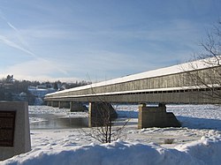
Longest covered bridge, showing pedestrian addition, with ice in the river
Fires
July 15, 1907
An arsonist starts a fire which consumes a large part of the town.[6][7] The town is rebuilt.
October 24, 1946
The town's dehydration plant, used to dehydrate potatoes, is destroyed by fire.[8] The adjacent glucose and starch plants are also consumed.[9]
August 25, 1980
A fire destroys many businesses on Main Street.[10]
Floods
Being built close to the Saint John River, the town is usually affected by the annual spring freshet. Ice jams threaten the Hartland Bridge,[11] it being a choke point for loose ice.
Notable people
See also
- List of communities in New Brunswick
References
^ Ketchum, T. C. L. (April 2008) [1922]. A Short History of Carleton County, New Brunswick. READ BOOKS. p. 61. ISBN 978-1-4086-9650-7. Retrieved 6 November 2010..mw-parser-output cite.citation{font-style:inherit}.mw-parser-output q{quotes:"""""""'""'"}.mw-parser-output code.cs1-code{color:inherit;background:inherit;border:inherit;padding:inherit}.mw-parser-output .cs1-lock-free a{background:url("//upload.wikimedia.org/wikipedia/commons/thumb/6/65/Lock-green.svg/9px-Lock-green.svg.png")no-repeat;background-position:right .1em center}.mw-parser-output .cs1-lock-limited a,.mw-parser-output .cs1-lock-registration a{background:url("//upload.wikimedia.org/wikipedia/commons/thumb/d/d6/Lock-gray-alt-2.svg/9px-Lock-gray-alt-2.svg.png")no-repeat;background-position:right .1em center}.mw-parser-output .cs1-lock-subscription a{background:url("//upload.wikimedia.org/wikipedia/commons/thumb/a/aa/Lock-red-alt-2.svg/9px-Lock-red-alt-2.svg.png")no-repeat;background-position:right .1em center}.mw-parser-output .cs1-subscription,.mw-parser-output .cs1-registration{color:#555}.mw-parser-output .cs1-subscription span,.mw-parser-output .cs1-registration span{border-bottom:1px dotted;cursor:help}.mw-parser-output .cs1-hidden-error{display:none;font-size:100%}.mw-parser-output .cs1-visible-error{font-size:100%}.mw-parser-output .cs1-subscription,.mw-parser-output .cs1-registration,.mw-parser-output .cs1-format{font-size:95%}.mw-parser-output .cs1-kern-left,.mw-parser-output .cs1-kern-wl-left{padding-left:0.2em}.mw-parser-output .cs1-kern-right,.mw-parser-output .cs1-kern-wl-right{padding-right:0.2em}
^ Barter, Samuel G. (1951). "Three". A Short History of the Orser Family. Avondale, New Brunswick.
^ Hamilton, William B. (1996). Place names of Atlantic Canada (Repr. ed.). Toronto [u.a.]: Univ. of Toronto Press. p. 83. ISBN 0802004717.
^ Kennedy, Doris E. (2009). "Hartland Salmon Pool". Hidden History of Hartland. pp. 197–210. ISBN 978-0-9813773-0-8.
^ "Gerry Perkins". Archived from the original on 15 July 2011. Retrieved 18 January 2011.With the installation of the Mactaquac Dam, it reduced the salmon fishing on the Saint John River in Hartland to nothing more than a wasted effort for the angler.
^ Kennedy, Doris E. (2009). "The Fire Monday July 15, 1907". Hidden History of Hartland. pp. 20–30. ISBN 978-0-9813773-0-8.
^ "Incendiary Fire at Hartland, N.B." The Ottawa Journal. 16 Jul 1907. p. 12. Retrieved 25 December 2016 – via Newspapers.com.
^ "$300,000 Fire Wipes Out Potato Dehydration Plant". The Ottawa Journal. 25 Oct 1946. p. 24. Retrieved 25 December 2016 – via Newspapers.com.
^ Kennedy, Doris E. (2009). "The Dehydration Plant in Hartland". Hidden History of Hartland. pp. 163, 165. ISBN 978-0-9813773-0-8.
^ Kennedy, Doris E. (2009). "Fire of August 1980 - Hartland Changes for Ever". Hidden History of Hartland. pp. 170–173. ISBN 978-0-9813773-0-8.
^ Kennedy, Doris E. (2009). "Floods and Ice Jams". Hidden History of Hartland. pp. 174–178. ISBN 978-0-9813773-0-8.
- Town of Hartland Website
| Subdivisions |
|
|---|---|
| Cities |
|
| Towns |
|
| |
Coordinates: 46°18′N 67°31′W / 46.300°N 67.517°W / 46.300; -67.517 (Hartland)


