Lochem
Lochem | |
|---|---|
Municipality and city | |
 Street in Lochem | |
 Flag Coat of arms | |
 Location in Gelderland | |
| Coordinates: 52°10′N 6°25′E / 52.167°N 6.417°E / 52.167; 6.417Coordinates: 52°10′N 6°25′E / 52.167°N 6.417°E / 52.167; 6.417 | |
| Country | Netherlands |
| Province | Gelderland |
| Government [1] | |
| • Body | Municipal council |
| • Mayor | Sebastiaan van ’t Erve (GL) |
| Area [2] | |
| • Total | 215.94 km2 (83.37 sq mi) |
| • Land | 213.20 km2 (82.32 sq mi) |
| • Water | 2.74 km2 (1.06 sq mi) |
| Elevation [3] | 14 m (46 ft) |
| Population (August 2017)[4] | |
| • Total | 33,688 |
| • Density | 158/km2 (410/sq mi) |
| Demonym(s) | Lochemer |
| Time zone | UTC+1 (CET) |
| • Summer (DST) | UTC+2 (CEST) |
| Postcode | 7210–7218, 7240–7245 |
| Area code | 0573, 0575 |
| Website | lochem.nl |

Dutch Topographic map of the municipality of Lochem, June 2015
Lochem (![]() pronunciation (help·info)) is a municipality and a city in the eastern Netherlands. On 1 January 2005, the municipality merged with the municipality of Gorssel.
pronunciation (help·info)) is a municipality and a city in the eastern Netherlands. On 1 January 2005, the municipality merged with the municipality of Gorssel.
Contents
1 Population centres
2 The city of Lochem
3 Transport
4 Photos
5 References
6 External links
Population centres
Small hamlets are printed in italics.
- Barchem
- Laren
- Lochem (city)
Formerly in Gorssel:
- Almen
Eefde (immediately north of Zutphen)
Epse ( near the A1{Amsterdam - Berlin} motorway)- Gorssel
- Harfsen
The city of Lochem
Lochem, 18 km (11 mi) east of Zutphen, received city rights in 1233.[5] Until the 17th century, it was often besieged and burnt down. After 1700, it became a small market town for the farmers in its surroundings.
The village of Laren (Gelderland) has a castle called Verwolde. In summer, guided tours of this castle are organized for tourists. On its estate there is a tree, said to be the thickest tree in the Netherlands ( "de dikke boom van Verwolde").
Transport
Lochem railway station - Railway Zutphen to Oldenzaal (line 73): Zutphen - Lochem - Goor (mun. Hof van Twente) - Delden (ditto) - Hengelo - Oldenzaal.
Photos
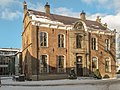
Lochem, former town hall

Lochem, church: de Gudulakerk
Lochem, monumental street light
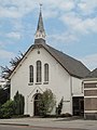
Lochem, church: de Witte Kerk
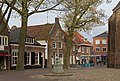
Lochem, monumental house on the Markt

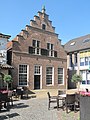
Lochem, monumental house at 't Ei

Lochem, river (de Berkel) from de Graaf Ottoweg

Lochem, bicycle bridge-bridge for pedestrians across the Berkel-weir

Zwiep, windmill: de Zwiepse Molen
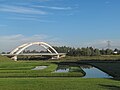
Lochem, bridge across Twentekanaal


References
^ "Burgemeester van 't Erve" [Mayor van 't Erve] (in Dutch). Gemeente Lochem. Retrieved 17 June 2014..mw-parser-output cite.citation{font-style:inherit}.mw-parser-output .citation q{quotes:"""""""'""'"}.mw-parser-output .citation .cs1-lock-free a{background:url("//upload.wikimedia.org/wikipedia/commons/thumb/6/65/Lock-green.svg/9px-Lock-green.svg.png")no-repeat;background-position:right .1em center}.mw-parser-output .citation .cs1-lock-limited a,.mw-parser-output .citation .cs1-lock-registration a{background:url("//upload.wikimedia.org/wikipedia/commons/thumb/d/d6/Lock-gray-alt-2.svg/9px-Lock-gray-alt-2.svg.png")no-repeat;background-position:right .1em center}.mw-parser-output .citation .cs1-lock-subscription a{background:url("//upload.wikimedia.org/wikipedia/commons/thumb/a/aa/Lock-red-alt-2.svg/9px-Lock-red-alt-2.svg.png")no-repeat;background-position:right .1em center}.mw-parser-output .cs1-subscription,.mw-parser-output .cs1-registration{color:#555}.mw-parser-output .cs1-subscription span,.mw-parser-output .cs1-registration span{border-bottom:1px dotted;cursor:help}.mw-parser-output .cs1-ws-icon a{background:url("//upload.wikimedia.org/wikipedia/commons/thumb/4/4c/Wikisource-logo.svg/12px-Wikisource-logo.svg.png")no-repeat;background-position:right .1em center}.mw-parser-output code.cs1-code{color:inherit;background:inherit;border:inherit;padding:inherit}.mw-parser-output .cs1-hidden-error{display:none;font-size:100%}.mw-parser-output .cs1-visible-error{font-size:100%}.mw-parser-output .cs1-maint{display:none;color:#33aa33;margin-left:0.3em}.mw-parser-output .cs1-subscription,.mw-parser-output .cs1-registration,.mw-parser-output .cs1-format{font-size:95%}.mw-parser-output .cs1-kern-left,.mw-parser-output .cs1-kern-wl-left{padding-left:0.2em}.mw-parser-output .cs1-kern-right,.mw-parser-output .cs1-kern-wl-right{padding-right:0.2em}
^ "Kerncijfers wijken en buurten" [Key figures for neighbourhoods]. CBS Statline (in Dutch). CBS. 2 July 2013. Retrieved 12 March 2014.
^ "Postcodetool for 7241AA". Actueel Hoogtebestand Nederland (in Dutch). Het Waterschapshuis. Archived from the original on 21 September 2013. Retrieved 17 June 2014.
^ "Bevolkingsontwikkeling; regio per maand" [Population growth; regions per month]. CBS Statline (in Dutch). CBS. 27 October 2017. Retrieved 27 October 2017.
^ "Stad Lochem", Mijn Gelderland. Retrieved on 14 April 2017.
External links
 Media related to Lochem at Wikimedia Commons
- Official website
Places adjacent to Lochem | ||||||||||
|---|---|---|---|---|---|---|---|---|---|---|
| ||||||||||
Municipalities of Gelderland | ||
|---|---|---|
|  | |
| ||
Authority control |
|
|---|


