Este (river)
This article may be expanded with text translated from the corresponding article in German. (September 2011) Click [show] for important translation instructions.
|
| Este | |
|---|---|
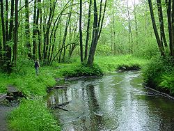 The Este near Kakenstorf. | |
| Location | |
| Country | Germany |
| Location | Lower Saxony, Hamburg |
| Physical characteristics | |
| Mouth | |
| - location | joins Elbe at Cranz, Hamburg |
| - coordinates | 53°32′10″N 9°47′28″E / 53.5362°N 9.7911°E / 53.5362; 9.7911Coordinates: 53°32′10″N 9°47′28″E / 53.5362°N 9.7911°E / 53.5362; 9.7911 |
| Length | 63.6 km (39.5 mi) [1] |
| Basin size | 361 km2 (139 sq mi) [1] |
| Discharge | |
| - average | 3.21 m3/s (113 cu ft/s) |
| Basin features | |
| Progression | Elbe→ North Sea |
| Tributaries | |
| - left | Goldbach |
The Este (![]() German pronunciation (help·info)) (Low Saxon: Eest) is a 63.6-kilometre-long (39.5 mi) left-bank tributary of the river Elbe that flows through Lower Saxony and Hamburg, Germany.
German pronunciation (help·info)) (Low Saxon: Eest) is a 63.6-kilometre-long (39.5 mi) left-bank tributary of the river Elbe that flows through Lower Saxony and Hamburg, Germany.
See also
- List of rivers of Hamburg
References
^ ab Environmental map service of Lower Saxony (Umweltkartendienst des Niedersächsischen Ministeriums für Umwelt, Energie und Klimaschutz)
This Hamburg location article is a stub. You can help Wikipedia by expanding it. |
This article related to a river in Lower Saxony is a stub. You can help Wikipedia by expanding it. |


